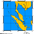
File:Selat Malaka.png
From Wikimedia Commons, the free media repository
Jump to navigation
Jump to search
Selat_Malaka.png (514 × 507 pixels, file size: 9 KB, MIME type: image/png)
File information
Structured data
Captions
Captions
Add a one-line explanation of what this file represents
Summary
[edit]| DescriptionSelat Malaka.png |
日本語: マラッカ海峡近辺の地図 |
| Date | 14 March 2005 (original upload date) |
| Source |
Transferred from ja.wikipedia. Original was http://www.aquarius.geomar.de/omc/omc_intro.html; *ソースのWEBで提供されたているGMT技術により提供者本人作成。GMT技術は、GDFL宣言をしています。
|
| Author | Original uploader was Kentin at ja.wikipedia |

|
This map image could be re-created using vector graphics as an SVG file. This has several advantages; see Commons:Media for cleanup for more information. If an SVG form of this image is available, please upload it and afterwards replace this template with
{{vector version available|new image name}}.
It is recommended to name the SVG file “Selat Malaka.svg”—then the template Vector version available (or Vva) does not need the new image name parameter. |
Licensing
[edit]
|
Permission is granted to copy, distribute and/or modify this document under the terms of the GNU Free Documentation License, Version 1.2 or any later version published by the Free Software Foundation; with no Invariant Sections, no Front-Cover Texts, and no Back-Cover Texts. A copy of the license is included in the section entitled GNU Free Documentation License.http://www.gnu.org/copyleft/fdl.htmlGFDLGNU Free Documentation Licensetruetrue |
| This file is licensed under the Creative Commons Attribution-Share Alike 3.0 Unported license. | ||
| ||
| This licensing tag was added to this file as part of the GFDL licensing update.http://creativecommons.org/licenses/by-sa/3.0/CC BY-SA 3.0Creative Commons Attribution-Share Alike 3.0truetrue |
Original upload log
[edit]The original description page was here. All following user names refer to ja.wikipedia.
- 2005-03-14 14:41 Kentin 514×507× (8706 bytes) マラッカ海峡近辺の地図

|
This file was moved from Japanese Wikipedia.
See below for original file information. | |||||||||||||||||||||||||||
| ||||||||||||||||||||||||||||
|
| ||||||||||||||||||||||||||||
File history
Click on a date/time to view the file as it appeared at that time.
| Date/Time | Thumbnail | Dimensions | User | Comment | |
|---|---|---|---|---|---|
| current | 12:03, 12 March 2006 |  | 514 × 507 (9 KB) | Maksim (talk | contribs) | La bildo estas kopiita de wikipedia:id. La originala priskribo estas: Selat Malaka {{GFDL}} {| border="1" ! date/time || username || edit summary |---- | 01:11, 4 April 2005 || id:Pengguna:*drew || <nowiki>(Selat Malaka {{GFDL}})</nowiki> |} ==== |
| 14:41, 14 March 2005 |  | 514 × 507 (9 KB) | Kentin (talk | contribs) | マラッカ海峡近辺の地図 |
You cannot overwrite this file.
File usage on Commons
The following page uses this file:
File usage on other wikis
The following other wikis use this file:
- Usage on ace.wikipedia.org
- Usage on en.wikipedia.org
- Usage on eo.wikipedia.org
- Usage on gor.wikipedia.org
- Usage on id.wikipedia.org
- Usage on ja.wikipedia.org
- Usage on la.wikipedia.org
- Usage on lt.wikipedia.org
- Usage on mk.wikipedia.org
- Usage on ml.wikipedia.org
- Usage on mr.wikipedia.org
- Usage on nn.wikipedia.org
- Usage on oc.wikipedia.org
- Usage on pt.wikipedia.org
- Usage on sl.wikipedia.org
- Usage on wuu.wikipedia.org
- Usage on zh-yue.wikipedia.org
