File:Second Cold War alliances.svg
Jump to navigation
Jump to search

Size of this PNG preview of this SVG file: 800 × 406 pixels. Other resolutions: 320 × 162 pixels | 640 × 325 pixels | 1,024 × 520 pixels | 1,280 × 650 pixels | 2,560 × 1,300 pixels | 2,754 × 1,398 pixels.
Original file (SVG file, nominally 2,754 × 1,398 pixels, file size: 1.18 MB)
Captions
Captions
Add a one-line explanation of what this file represents
 This media file has been nominated for deletion since 17 August 2024. To discuss it, please visit the nomination page.
Do not remove this tag until the deletion nomination is closed. Reason for the nomination: I created this file and believe it should be deleted because I'm not updating it, and the premise of depicting what I want to depict in just this one file is not very realistic
| |||
| |||
Summary
[edit]
| Description |
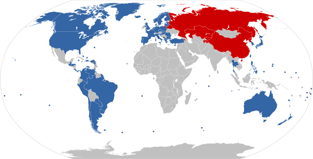
English: A simplified map of the Second Cold War alliances. The CSTO and Chinese blocs are grouped together as one for illustrative purposes, but note that not all CSTO and Chinese allies are aligned with the allies of the other. The grey region does not represent an alliance, but rather encompasses all countries that are not aligned with NATO, CSTO, or China. This map is based on File:BlankMap-World-Microstates-Unrecognised.svg.
Rationale:
Eastern-aligned:
|
| Date | |
| Source | Own work |
| Author | Discombobulates |
Licensing
[edit]
I, the copyright holder of this work, hereby publish it under the following license:
This file is licensed under the Creative Commons Attribution-Share Alike 4.0 International license.
- You are free:
- to share – to copy, distribute and transmit the work
- to remix – to adapt the work
- Under the following conditions:
- attribution – You must give appropriate credit, provide a link to the license, and indicate if changes were made. You may do so in any reasonable manner, but not in any way that suggests the licensor endorses you or your use.
- share alike – If you remix, transform, or build upon the material, you must distribute your contributions under the same or compatible license as the original.
File history
Click on a date/time to view the file as it appeared at that time.
| Date/Time | Thumbnail | Dimensions | User | Comment | |
|---|---|---|---|---|---|
| current | 16:19, 7 August 2024 | | 2,754 × 1,398 (1.18 MB) | Discombobulates (talk | contribs) | Venezuela |
| 15:15, 7 March 2024 |  | 2,754 × 1,398 (1.18 MB) | Discombobulates (talk | contribs) | Sweden joins NATO | |
| 13:05, 22 August 2023 |  | 2,754 × 1,398 (1.18 MB) | Discombobulates (talk | contribs) | Remove non-mutual defence alliance | |
| 11:40, 10 August 2023 |  | 2,754 × 1,398 (1.18 MB) | Discombobulates (talk | contribs) | Remove non-alliances | |
| 13:39, 22 April 2023 |  | 2,754 × 1,398 (1.18 MB) | Discombobulates (talk | contribs) | Add Norway's Bouvet Island | |
| 15:30, 17 April 2023 |  | 2,754 × 1,398 (1.18 MB) | Discombobulates (talk | contribs) | Remove Wagner presence as an eastern-alignement qualifier | |
| 16:02, 16 April 2023 |  | 2,754 × 1,398 (1.18 MB) | Discombobulates (talk | contribs) | Don't prospectively colour non-member states | |
| 15:49, 16 April 2023 |  | 2,754 × 1,398 (1.18 MB) | Discombobulates (talk | contribs) | Add members of NATO's MD and ICI, members of the QUAD, and states with a Russian mercenary presence | |
| 20:06, 6 April 2023 |  | 2,754 × 1,398 (1.18 MB) | Discombobulates (talk | contribs) | Include all NATO overseas territories | |
| 19:22, 6 April 2023 |  | 2,754 × 1,398 (1.18 MB) | Discombobulates (talk | contribs) | Add Bermuda and Saint Pierre and Miquelon as part of NATO |
You cannot overwrite this file.
File usage on Commons
There are no pages that use this file.