File:Seaboard villages OS map 1950.jpeg
Jump to navigation
Jump to search

Size of this preview: 600 × 600 pixels. Other resolutions: 240 × 240 pixels | 480 × 480 pixels | 768 × 768 pixels | 1,024 × 1,024 pixels | 2,056 × 2,056 pixels.
Original file (2,056 × 2,056 pixels, file size: 655 KB, MIME type: image/jpeg)
Captions
Captions
Add a one-line explanation of what this file represents
Summary
[edit]
| Description |
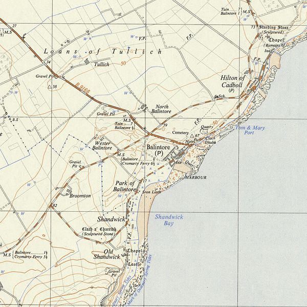
English: Old Ordnance Surve Map (1950), showing the Seabord Villages on Tarbat Peninsula, Easter Ross, Scotland. Map includes the Villages of Balintore, Hilton of Cadboll and Shandwick as well as the locations of two Pictish Stones near Shandwick and near Hilton of Cadboll.
Deutsch: Ordnance Survey Map von 1950 mit den als Seaboard Villages bekannten Orten Balintore, Hilton of Cadboll und Shandwick auf der Tarbat-Halbinsel im Ostteil der ehemaligen Grafschaft Ross, Schottland. Zu sehen sind auch die Orte zweier Piktischer Symbolsteine bei Shandwick und bei Hilton of Cadboll. |
| Date | |
| Source | http://maps.nls.uk/os/25k-gb-1937-61/view/?jp2=91626672 |
| Author | Ordnance Survey |
Licensing
[edit]
This work is an Ordnance Survey map over 50 years old, which is covered by Crown Copyright which in this case expires 50 years after publication. Ordnance Survey does however ask that they be credited and that the date of publication be given.
Any ancillary rights gained through the creation of the electronic version are granted as freely usable under any circumstances.
|
This work created by the United Kingdom Government is in the public domain.
This is because it is one of the following:
HMSO has declared that the expiry of Crown Copyrights applies worldwide (ref: HMSO Email Reply)
|
 |
File history
Click on a date/time to view the file as it appeared at that time.
| Date/Time | Thumbnail | Dimensions | User | Comment | |
|---|---|---|---|---|---|
| current | 22:33, 30 August 2012 | | 2,056 × 2,056 (655 KB) | Kallewirsch (talk | contribs) | {{Information |Description ={{en|1=Old Ordnance Surve Map (1950), showing the Seabord Villages on Tarbat Peninsula, Easter Ross, Scotland. Map includes the Villages of Balintore, Hilton of Cadboll and Shandwick as well as the locations of two Pictis... |
You cannot overwrite this file.
File usage on Commons
There are no pages that use this file.
File usage on other wikis
The following other wikis use this file:
- Usage on de.wikipedia.org