File:San Vicente de Cañete, Perú.jpg
Jump to navigation
Jump to search
Size of this preview: 800 × 450 pixels. Other resolutions: 320 × 180 pixels | 640 × 360 pixels | 1,024 × 576 pixels | 1,280 × 720 pixels | 2,768 × 1,557 pixels.
Original file (2,768 × 1,557 pixels, file size: 1.12 MB, MIME type: image/jpeg)
Captions
Captions
Add a one-line explanation of what this file represents
Summary
[edit]
| Description |
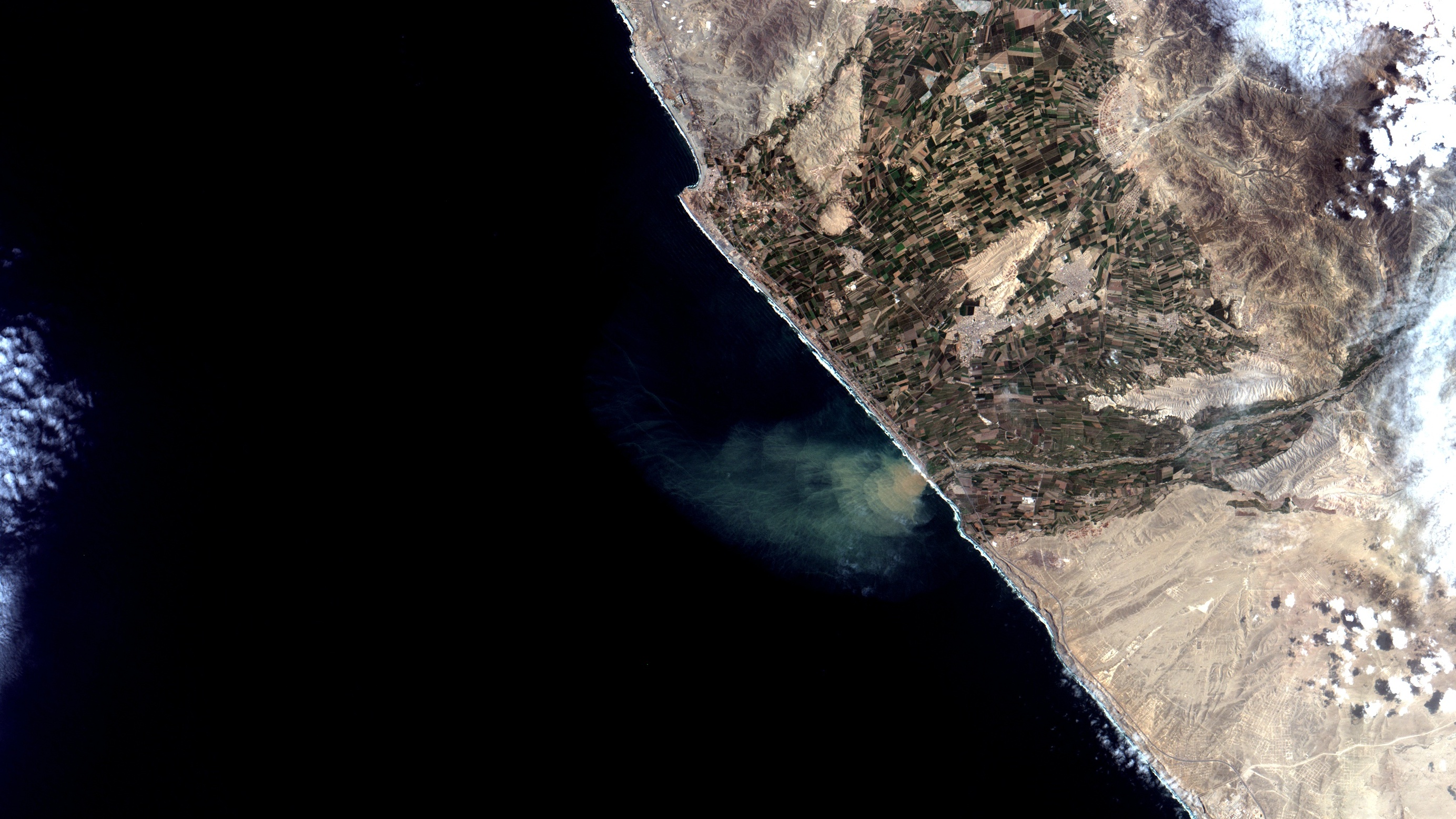
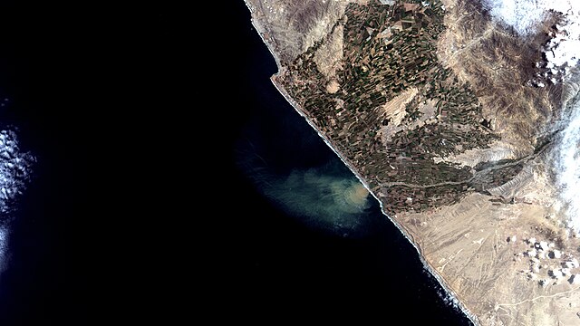
Português: Pluma de sedimentos do Rio Cañete no Oceano Pacífico em São Vicente do Cañete, Perú. No alto à esq. o famoso pico de surf de Cerro Azul. Em branco, no mar, espuma das ondas quebrando. Em marrom águas carregadas de sedimentos do rio. Em preto e azul escuro, águas claras. No continente o padrão quadriculado são lotes de agricultura irrigada, principalmente com frutíferas, como videiras e macieiras, batata, algodão e milho. Em amarelo claro deserto. Áreas urbanas em salpicado / Cañete River sediment plume on the Pacific Ocean at Peru´s San Vicente de Cañete.At image top left is the famous Cerro Azul surfing spot. In white, at sea, crashing waves foam. In brown river sediment ladden waters. In black and dark blue, clear waters. Checkered pattern on the continent are agriculture plots, mostly fruits like grape vines and apple trees, potatoes, cotton and maize. Desert appears in yellow and urban areas in saltpepper.
Imagem / Image CBERS4 MUX San Vicente de Cañete, Perú Coordenadas do centro da imagem / Image center: 13°05'48.6"S 76°25'49.0"W Data / Date: 02-03-2020 / 2020-03-02 RGB 765 (cor verdadeira / true color) Cena / Scene: 188 / 115 Autor / Author: Oton Barros (DSR/OBT/INPE) Imagem em HD / HD Image Visite-nos em www.dsr.inpe.br |
| Date | |
| Source | https://www.flickr.com/photos/153282474@N02/49614396812/ |
| Author | Coordenação-Geral de Observação da Terra/INPE |
Licensing
[edit]
This file is licensed under the Creative Commons Attribution-Share Alike 2.0 Generic license.
- You are free:
- to share – to copy, distribute and transmit the work
- to remix – to adapt the work
- Under the following conditions:
- attribution – You must give appropriate credit, provide a link to the license, and indicate if changes were made. You may do so in any reasonable manner, but not in any way that suggests the licensor endorses you or your use.
- share alike – If you remix, transform, or build upon the material, you must distribute your contributions under the same or compatible license as the original.
| This image was originally posted to Flickr by Coordenação-Geral de Observação da Terra/INPE at https://flickr.com/photos/153282474@N02/49614396812. It was reviewed on 9 April 2020 by FlickreviewR 2 and was confirmed to be licensed under the terms of the cc-by-sa-2.0. |
File history
Click on a date/time to view the file as it appeared at that time.
| Date/Time | Thumbnail | Dimensions | User | Comment | |
|---|---|---|---|---|---|
| current | 10:11, 9 April 2020 | | 2,768 × 1,557 (1.12 MB) | Jo-Jo Eumerus (talk | contribs) | Uploaded a work by Coordenação-Geral de Observação da Terra/INPE from https://www.flickr.com/photos/153282474@N02/49614396812/ with UploadWizard |
You cannot overwrite this file.
File usage on Commons
The following page uses this file:
- File:San Vicente de Cañete, Perú (49614396812).jpg (file redirect)
.jpg&redirect=no)