File:Samaritan communities map.png
Jump to navigation
Jump to search
No higher resolution available.
Samaritan_communities_map.png (500 × 333 pixels, file size: 16 KB, MIME type: image/png)
Captions
Captions
Add a one-line explanation of what this file represents
Summary
[edit]
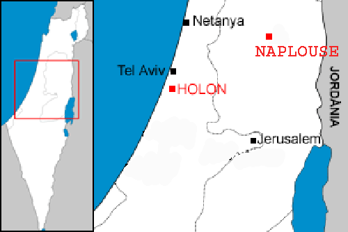
| Description | Localization of the two samaritan communities : Holon in Israel, and Nablus in the west bank. |
| Date | |
| Source | Image:Localització de Holon.png |
| Author | modified by Christophe cagé 09:54, 4 January 2007 (UTC) |
| Permission (Reusing this file) |
see license (Public domain) of original image |
| Other versions | Image:Localització de Holon.png |
Licensing
[edit]
| |
This work has been released into the public domain by its author, Rf, at the English Wikipedia project. This applies worldwide. In case this is not legally possible: |
File history
Click on a date/time to view the file as it appeared at that time.
| Date/Time | Thumbnail | Dimensions | User | Comment | |
|---|---|---|---|---|---|
| current | 09:54, 4 January 2007 | | 500 × 333 (16 KB) | Christophe cagé (talk | contribs) | {{Information |Description=Localization of the two samaritan communities : Holon in Israel, and Nablus in the west bank. |Source=Image:Localització de Holon.png |Date=~~~~ |Author=modified by ~~~~ |Permission=see license (Public domain) of original |
You cannot overwrite this file.
File usage on Commons
The following page uses this file:
File usage on other wikis
The following other wikis use this file:
- Usage on af.wikipedia.org
- Usage on fr.wikipedia.org
- Usage on it.wikipedia.org
- Usage on nl.wikipedia.org
- Usage on pt.wikipedia.org