File:SCHEMAT LINII KOLEJOWYCH W TRÓJMIEŚCIE SKM PKM.png

Original file (1,488 × 1,401 pixels, file size: 651 KB, MIME type: image/png)
Captions
Captions
Summary
[edit]| DescriptionSCHEMAT LINII KOLEJOWYCH W TRÓJMIEŚCIE SKM PKM.png |
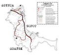
Polski: Schemat większości linii kolejowych w Gdyni, Sopocie i Gdańsku z zaznaczeniem stacji i przystanków w tym - większości zamkniętych i planowanych oraz budowanych aktualnie.
Czarna mgiełka - Istniejący, standardowy przebieg SKM na terenie Trójmiasta Czerwona mgiełka - Planowany przebieg Pomorskiej Kolei MetropolitalnejEnglish: The outline of majority of railways in Gdynia, Sopot and Gdańsk with stations and stops - ones closed, planned and being build at the moment - marked on it.
Black fog - Existing route of a standard route of SKM in borders of Tricity; Red fog - Planned route of PKM |
| Date | |
| Source | Own work |
| Author | Moder9781 |
Licensing
[edit]- You are free:
- to share – to copy, distribute and transmit the work
- to remix – to adapt the work
- Under the following conditions:
- attribution – You must give appropriate credit, provide a link to the license, and indicate if changes were made. You may do so in any reasonable manner, but not in any way that suggests the licensor endorses you or your use.
- share alike – If you remix, transform, or build upon the material, you must distribute your contributions under the same or compatible license as the original.
File history
Click on a date/time to view the file as it appeared at that time.
| Date/Time | Thumbnail | Dimensions | User | Comment | |
|---|---|---|---|---|---|
| current | 18:11, 10 February 2017 |  | 1,488 × 1,401 (651 KB) | Moder9781 (talk | contribs) | Dodanie informacji w legendzie. Odświeżenie szaty graficznej. aktualizacja informacji na schemacie |
| 17:42, 10 October 2013 |  | 2,150 × 2,023 (826 KB) | Moder9781 (talk | contribs) | User created page with UploadWizard |
You cannot overwrite this file.
File usage on Commons
The following 4 pages use this file:
File usage on other wikis
The following other wikis use this file:
- Usage on be-tarask.wikipedia.org
- Usage on be.wikipedia.org
- Usage on en.wikipedia.org
- Usage on lmo.wikipedia.org
- Usage on pl.wikipedia.org
- Usage on ru.wikipedia.org
Metadata
This file contains additional information such as Exif metadata which may have been added by the digital camera, scanner, or software program used to create or digitize it. If the file has been modified from its original state, some details such as the timestamp may not fully reflect those of the original file. The timestamp is only as accurate as the clock in the camera, and it may be completely wrong.
| Horizontal resolution | 35.43 dpc |
|---|---|
| Vertical resolution | 35.43 dpc |
| Software used |