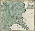
File:Russian Empire 1745 (Map XVIII in Latin).jpg

Original file (7,488 × 6,763 pixels, file size: 14.32 MB, MIME type: image/jpeg)
Captions
Captions
Summary
[edit]| DescriptionRussian Empire 1745 (Map XVIII in Latin).jpg |
Русский: Первый официальный атлас Российской империи (1745). Часть Якутского уезда и большая часть Камчатки. На латинском языке. Оригинальная карта гравирована на меди и раскрашена вручную акварелью.
English: First official geographic atlas of the Russian Empire (1745) in Latin. Part of Yakutsk uyezd and major part of Kamchatka. Hand-coloured copper engraving. |
| Date | |
| Source |
Русский: Атлас Российский (1745)
English: Geographic atlas of the Russian Empire (1745) |
| Author | РАН (Russian Academy of Science) |
| Other versions |
|
Licensing
[edit]| Public domainPublic domainfalsefalse |
|
This work is in the public domain in its country of origin and other countries and areas where the copyright term is the author's life plus 100 years or fewer. | |
| This file has been identified as being free of known restrictions under copyright law, including all related and neighboring rights. | |
https://creativecommons.org/publicdomain/mark/1.0/PDMCreative Commons Public Domain Mark 1.0falsefalse
File history
Click on a date/time to view the file as it appeared at that time.
| Date/Time | Thumbnail | Dimensions | User | Comment | |
|---|---|---|---|---|---|
| current | 17:51, 6 March 2011 |  | 7,488 × 6,763 (14.32 MB) | Transcend (rus) (talk | contribs) | {{LargeImage}} == {{int:filedesc}} == {{Information |Description= {{ru|1=Первый официальный атлас Российской империи (1745). Часть Якутского уезда и большая часть Камчатки. Н� |
You cannot overwrite this file.
File usage on Commons
The following 2 pages use this file:
Metadata
This file contains additional information such as Exif metadata which may have been added by the digital camera, scanner, or software program used to create or digitize it. If the file has been modified from its original state, some details such as the timestamp may not fully reflect those of the original file. The timestamp is only as accurate as the clock in the camera, and it may be completely wrong.
| Orientation | Normal |
|---|---|
| Software used | ACD Systems Digital Imaging |
| File change date and time | 16:49, 30 October 2006 |
| Y and C positioning | Centered |
| Exif version | 2.2 |
| DateTime subseconds | 515 |

