File:Ridge Route northside info signs.jpg
Jump to navigation
Jump to search

Size of this preview: 800 × 540 pixels. Other resolutions: 320 × 216 pixels | 640 × 432 pixels | 1,024 × 692 pixels | 1,280 × 865 pixels | 1,818 × 1,228 pixels.
Original file (1,818 × 1,228 pixels, file size: 1.04 MB, MIME type: image/jpeg)
Captions
Captions
Add a one-line explanation of what this file represents
Summary
[edit]
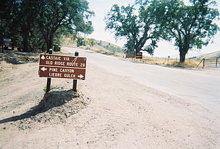
English: Junction on the historic Ridge Route, in the Sierra Pelona Mountains, northern Los Angeles County, California.
- Looking south on the Ridge Route's northern boundary with Angeles National Forest. The 28 miles to Castaic is to the site of the historic Castaic School in Castaic, now the site of a Fire Station. To the right of the photograph is a "No Firearms" sign and a sign announcing the beginning of The Ridge Route as protected on the National Register of Historic Places to southbound travelers.
- The northbound traveler before 1933 would continue to Gorman and Lebec, then endure the steeply graded and curved Deadman's Curve - and probably take a break at the first flat spot in the San Joaquin Valley in the original townsite of Grapevine, now paved over by Interstate 5. Except for Gorman Post Road, most of the original Ridge Route north of this photograph's location is paved under Interstate 5, with a small section replaced by part of California State Highway 138.
- The photo tour offered here is over, yet the traveler's tour can continue on to the historical northern Ridge Route terminus at the modern day traveler's stop of Grapevine - if so desired.
- Credits
- Photo from private collection of avnative.
Licensing
[edit]
| This work has been released into the public domain by its author, Avnative at English Wikipedia. This applies worldwide. In some countries this may not be legally possible; if so: Avnative grants anyone the right to use this work for any purpose, without any conditions, unless such conditions are required by law. |
File history
Click on a date/time to view the file as it appeared at that time.
| Date/Time | Thumbnail | Dimensions | User | Comment | |
|---|---|---|---|---|---|
| current | 03:56, 16 March 2007 | | 1,818 × 1,228 (1.04 MB) | Fran Rogers (talk | contribs) | Looking south on the Ridge Route's northern boundary with Angeles National Forest. The 28 miles to Castaic is to the site of the historic Castaic School in Castaic, now the site of a Fire Station. To the right of the photograph is |
You cannot overwrite this file.
File usage on Commons
The following page uses this file: