File:Punjab 1951-66.svg
Jump to navigation
Jump to search

Size of this PNG preview of this SVG file: 800 × 324 pixels. Other resolutions: 320 × 130 pixels | 640 × 259 pixels | 1,024 × 414 pixels | 1,280 × 518 pixels | 2,560 × 1,036 pixels | 1,055 × 427 pixels.
Original file (SVG file, nominally 1,055 × 427 pixels, file size: 50 KB)
Captions
Captions
Add a one-line explanation of what this file represents
Summary
[edit]
| Description |
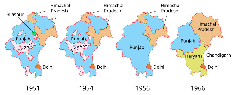
Deutsch: Territoriale Entwicklung des Punjab und benachbarter Bundesstaaten bzw. Unionsterritorien in Indien zwischen 1951 und 1966:
English: Territorial evolution of Punjab and neighbouring states and Union territories in India between 1951 and 1966. |
| Date | |
| Source | Own work using data from the Census of India |
| Author | Furfur |
| Permission (Reusing this file) |
I, the copyright holder of this work, hereby publish it under the following license: This file is licensed under the Creative Commons Attribution-Share Alike 4.0 International license.
|
| Other versions |
[]
|
File history
Click on a date/time to view the file as it appeared at that time.
| Date/Time | Thumbnail | Dimensions | User | Comment | |
|---|---|---|---|---|---|
| current | 12:24, 25 December 2020 | 1,055 × 427 (50 KB) | Ibrahim.ID (talk | contribs) | Reverted to version as of 17:40, 2 March 2019 (UTC) | |
| 12:23, 25 December 2020 | 1,055 × 427 (55 KB) | Ibrahim.ID (talk | contribs) | File uploaded using svgtranslate tool (https://svgtranslate.toolforge.org/). Added translation for ar. | ||
| 17:40, 2 March 2019 | 1,055 × 427 (50 KB) | Furfur (talk | contribs) | Korrektur: ein "Punjab" zu viel | ||
| 12:07, 10 October 2015 | 1,055 × 427 (59 KB) | Furfur (talk | contribs) | Fehlerkorrektur (Bilaspur) | ||
| 11:56, 10 October 2015 | 1,055 × 427 (44 KB) | Furfur (talk | contribs) | Präzisierung und Korrektur, PEPSU wurde wohl vollständig an den Punjab angegliedert | ||
| 20:06, 19 September 2015 |  | 976 × 427 (31 KB) | Furfur (talk | contribs) | Fehlerkorrektur | |
| 10:08, 28 August 2015 |  | 976 × 427 (28 KB) | Furfur (talk | contribs) | Kosmetik | |
| 10:05, 28 August 2015 |  | 953 × 427 (28 KB) | Furfur (talk | contribs) | =={{int:filedesc}}== {{Information |Description={{de|1=Territoriale Entwicklung des Punjab und benachbarter Bundesstaaten bzw. Unionsterritorien in Indien zwischen 1951 und 1971.}} {{en|1=Territorial evolution of Punjab and neighbouring states and Unio... |
You cannot overwrite this file.
File usage on Commons
The following 13 pages use this file:
- User:Magog the Ogre/Multilingual legend/2020 December 21-31
- File:Punjab 1951-66-bn.svg
- File:Punjab 1951-66-gu.svg
- File:Punjab 1951-66-hi.svg
- File:Punjab 1951-66-kn.svg
- File:Punjab 1951-66-mr.svg
- File:Punjab 1951-66-pa.svg
- File:Punjab 1951-66-te.svg
- File:Punjab 1951-66.od.svg
- File:Punjab 1951-66.svg
- File:Punjab 1951-66 as.svg
- File:Punjab 1951-71.svg (file redirect)
- Template:Other versions/Punjab 1951-66
File usage on other wikis
The following other wikis use this file:
- Usage on bn.wikipedia.org
- Usage on de.wikipedia.org
- Usage on en.wikipedia.org
- Usage on es.wikipedia.org
- Usage on lv.wikipedia.org
- Usage on pa.wikipedia.org
- Usage on pnb.wikipedia.org
- Usage on ru.wikipedia.org
- Usage on ta.wikipedia.org