File:Progress on the picnic area, 1984 (geograph 6541229).jpg
Jump to navigation
Jump to search

Size of this preview: 800 × 527 pixels. Other resolutions: 320 × 211 pixels | 640 × 422 pixels | 1,024 × 674 pixels | 1,280 × 843 pixels.
Original file (1,280 × 843 pixels, file size: 477 KB, MIME type: image/jpeg)
Captions
Captions
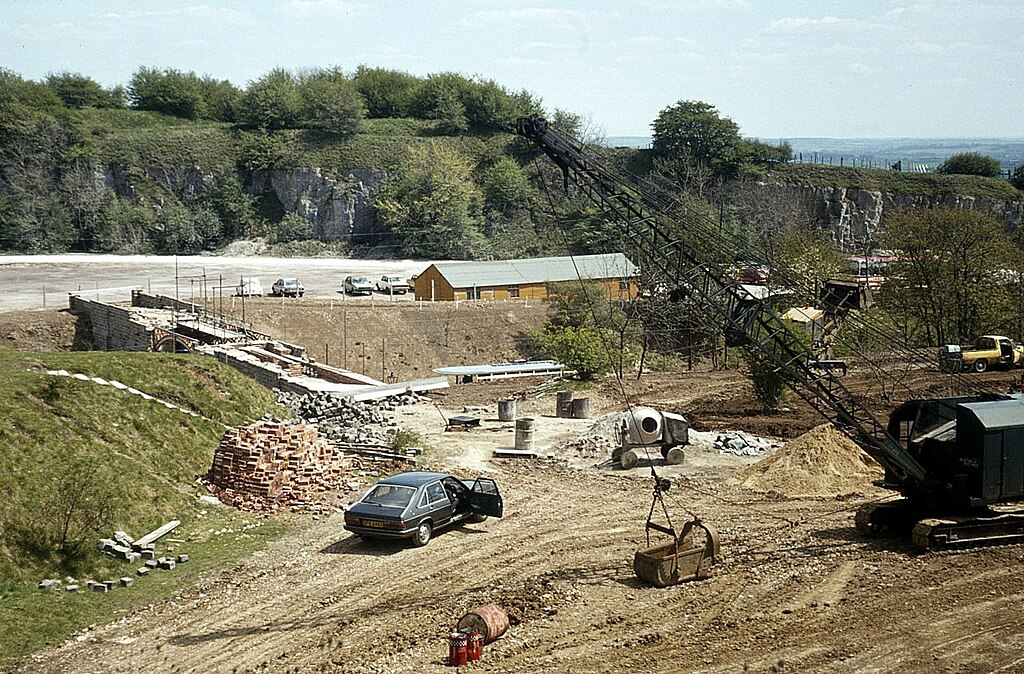
Behind the scenes construction at the National Tramway Museum in Crich, Derbyshire, UK. The partially completed Bowes Lyon bridge can be seen on the left. The dragline excavator was being used to clear spoil in preparation for the development of ...
Summary
[edit].jpg&action=edit§ion=1)
| Description |
English: Behind the scenes construction at the National Tramway Museum in Crich, Derbyshire, UK. The partially completed Bowes Lyon bridge can be seen on the left. The dragline excavator was being used to clear spoil in preparation for the development of the new Great Exhibition Hall. The running line is out of sight in the cutting that is bridged by the Bowes-Lyon Bridge, although the roof of a tram car on it can just be made out. The flat expanse on the other side of the bridge is the car park. |
| Date | Taken in May 1984 |
| Source | From geograph.org.uk |
| Author | Alan Murray-Rust |
| Permission (Reusing this file) |
Creative Commons Attribution Share-alike license 2.0 |
| Attribution (required by the license) | Alan Murray-Rust / Progress on the picnic area, 1984 / |
| Camera location | | View this and other nearby images on: OpenStreetMap |
|---|
.jpg¶ms=053.092188_N_-001.488081_E_globe:Earth_type:camera_source:geograph-osgb36(SK34385512)_heading:112.00&language=en)
| Object location | | View this and other nearby images on: OpenStreetMap |
|---|
.jpg¶ms=053.091910_N_-001.487040_E_globe:Earth_class:object_type:object_source:geograph-osgb36(SK34455509)_heading:112.00&language=en)
Licensing
[edit].jpg&action=edit§ion=2)

|
This image was taken from the Geograph project collection. See this photograph's page on the Geograph website for the photographer's contact details. The copyright on this image is owned by Alan Murray-Rust and is licensed for reuse under the Creative Commons Attribution-ShareAlike 2.0 license.
|
This file is licensed under the Creative Commons Attribution-Share Alike 2.0 Generic license.
Attribution: Alan Murray-Rust
- You are free:
- to share – to copy, distribute and transmit the work
- to remix – to adapt the work
- Under the following conditions:
- attribution – You must give appropriate credit, provide a link to the license, and indicate if changes were made. You may do so in any reasonable manner, but not in any way that suggests the licensor endorses you or your use.
- share alike – If you remix, transform, or build upon the material, you must distribute your contributions under the same or compatible license as the original.
File history
Click on a date/time to view the file as it appeared at that time.
| Date/Time | Thumbnail | Dimensions | User | Comment | |
|---|---|---|---|---|---|
| current | 15:45, 26 March 2024 | | 1,280 × 843 (477 KB) | Chris j wood (talk | contribs) | == {{int:filedesc}} == {{Information |Description={{en|1=Progress on the picnic area, 1984}} |Source=From [https://www.geograph.org.uk/photo/6541229 geograph.org.uk] |Date=1984-05 |Author=[https://www.geograph.org.uk/profile/9181 Alan Murray-Rust] |Permission=Creative Commons Attribution Share-alike license 2.0 |Other fields={{Credit line |Author=Alan Murray-Rust |License=[https://creativecommons.org/licenses/by-sa/2.0/ CC BY-SA 2.0] |Other=''Progress on the picnic area, 1984'' }} }} {{Lo... |
You cannot overwrite this file.
File usage on Commons
The following page uses this file:
File usage on other wikis
The following other wikis use this file:
- Usage on en.wikipedia.org
.jpg&oldid=909213063)