File:Priorslee Lake - geograph.org.uk - 864371.jpg
Jump to navigation
Jump to search
No higher resolution available.
Priorslee_Lake_-_geograph.org.uk_-_864371.jpg (640 × 480 pixels, file size: 88 KB, MIME type: image/jpeg)
Captions
Captions
Add a one-line explanation of what this file represents
Summary
[edit]
| Description |
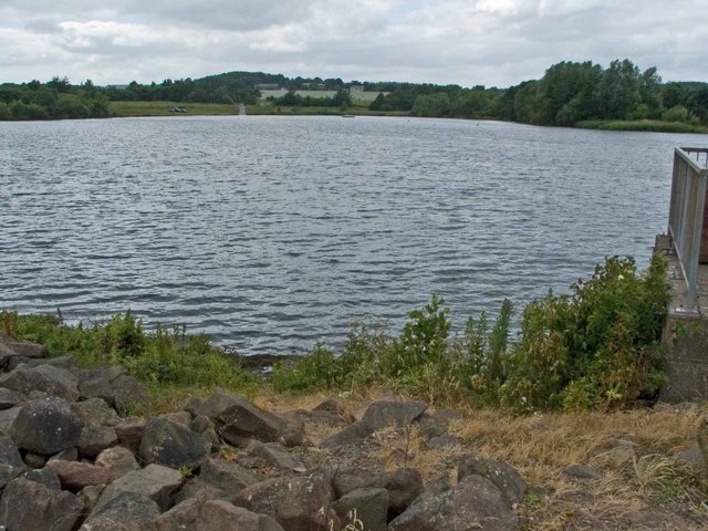
English: Priorslee Lake Originally called the Balancing Lake, it was created to manage water run-off from the roofs and streets of Priorslee, where thousands of new houses have been built in the last quarter-century. Then it was named Castle Farm Lake after Castle Farm, submerged beneath its waters. It's on its third name now; perhaps this will stick. The rocks in the foreground form the dam, which carries the B5060 Castle Farm Way. The long pale green building in the distance is a factory unit and behind that is 18th century Priorslee Hall and modern buildings which house the University of Wolverhampton in Telford. |
| Date | |
| Source | From geograph.org.uk |
| Author | Mike White |
| Attribution (required by the license) | Mike White / Priorslee Lake / |
| Camera location | | View this and other nearby images on: OpenStreetMap |
|---|
_heading:270.00&language=en)
| Object location | | View this and other nearby images on: OpenStreetMap |
|---|
_heading:270.00&language=en)
Licensing
[edit]

|
This image was taken from the Geograph project collection. See this photograph's page on the Geograph website for the photographer's contact details. The copyright on this image is owned by Mike White and is licensed for reuse under the Creative Commons Attribution-ShareAlike 2.0 license.
|
This file is licensed under the Creative Commons Attribution-Share Alike 2.0 Generic license.
Attribution: Mike White
- You are free:
- to share – to copy, distribute and transmit the work
- to remix – to adapt the work
- Under the following conditions:
- attribution – You must give appropriate credit, provide a link to the license, and indicate if changes were made. You may do so in any reasonable manner, but not in any way that suggests the licensor endorses you or your use.
- share alike – If you remix, transform, or build upon the material, you must distribute your contributions under the same or compatible license as the original.
File history
Click on a date/time to view the file as it appeared at that time.
| Date/Time | Thumbnail | Dimensions | User | Comment | |
|---|---|---|---|---|---|
| current | 06:24, 21 February 2011 | | 640 × 480 (88 KB) | GeographBot (talk | contribs) | == {{int:filedesc}} == {{Information |description={{en|1=Priorslee Lake Originally called the Balancing Lake, it was created to manage water run-off from the roofs and streets of Priorslee, where thousands of new houses have been built in the last quarter |
You cannot overwrite this file.
File usage on Commons
There are no pages that use this file.
File usage on other wikis
The following other wikis use this file:
- Usage on en.wikipedia.org
- Usage on fa.wikipedia.org