File:Powiat wadowicki location map.png

Original file (930 × 751 pixels, file size: 233 KB, MIME type: image/png)
Captions
Captions
Summary
[edit]
| Description |
English: Location map |
| Date | |
| Source | Own work |
| Author | Smat |
| Description |
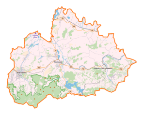
Polski: Mapa powiatu wadowickiego, Polska
English: Map of powiat wadowicki, Poland |
|||||||||
| Date | ||||||||||
| Source | You may find a page on the OpenStreetMap wiki page for powiat wadowicki | |||||||||
| Creator |
OpenStreetMap contributors OpenStreetMap contributors |
|||||||||
| Permission (Reusing this file) |
OpenStreetMap data is available under the Open Database License (details). Map tiles are licensed under the Creative Commons Attribution-ShareAlike 2.0 license (CC-BY-SA 2.0).
This file is licensed under the Creative Commons Attribution-Share Alike 2.0 Generic license.
|
|||||||||
| Geotemporal data | ||||||||||
| Bounding box |
|
|||||||||
| Georeferencing | If inappropriate please set warp_status = skip to hide. | |||||||||
Licensing
[edit]
| This work contains information from OpenStreetMap, which is made available under the Open Database License (ODbL).
The ODbL does not require any particular license for maps produced from ODbL data. Prior to 1 August 2020, map tiles produced by the OpenStreetMap Foundation were licensed under the CC-BY-SA-2.0 license. Maps produced by other people may be subject to other licences. |
File history
Click on a date/time to view the file as it appeared at that time.
| Date/Time | Thumbnail | Dimensions | User | Comment | |
|---|---|---|---|---|---|
| current | 16:46, 31 May 2018 | | 930 × 751 (233 KB) | Smat (talk | contribs) | User created page with UploadWizard |
You cannot overwrite this file.
File usage on Commons
There are no pages that use this file.
File usage on other wikis
The following other wikis use this file:
- Usage on ja.wikipedia.org
- Usage on pl.wikipedia.org
- Kalwaria Zebrzydowska
- Andrychów
- Leskowiec
- Lanckorona
- Wadowice
- Rzyki
- Inwałd
- Targanice
- Rezerwat przyrody Madohora
- Pańska Góra (Beskid Mały)
- Brzezinka (gmina Andrychów)
- Złota Górka (Beskid Mały)
- Zagórnik (województwo małopolskie)
- Mucharz
- Potrójna (szczyt)
- Sułkowice (powiat wadowicki)
- Roczyny
- Targaniczanka
- Wapiennica
- Ostry Wierch (Beskid Mały)
- Iłowiec (szczyt)
- Bliźniaki (szczyt)
- Jaszczurowa (województwo małopolskie)
- Koziniec (województwo małopolskie)
- Świnna Poręba
- Andrychowska Fabryka Maszyn DEFUM
- Wytwórnia Silników Wysokoprężnych Andoria
- Andropol
- Chocznia
- Kaczyna (województwo małopolskie)
- Jawornica (szczyt)
- Lgota (powiat wadowicki)
- Radocza
- Witanowice (województwo małopolskie)
- Zygodowice
- Bachowice
- Ryczów (województwo małopolskie)
- Frydrychowice
- Nidek
- Brzeźnica (powiat wadowicki)
- Klecza Dolna
- Klecza Górna
- Izdebnik (województwo małopolskie)
- Stryszów
- Zakrzów (powiat wadowicki)
- Skawinki
- Bugaj (powiat wadowicki)
- Brody (województwo małopolskie)
View more global usage of this file.