File:Pontypool Road railway station (site), Gwent (geograph 4387476).jpg
Jump to navigation
Jump to search

Size of this preview: 800 × 600 pixels. Other resolutions: 320 × 240 pixels | 640 × 480 pixels | 1,024 × 768 pixels | 1,280 × 960 pixels | 1,600 × 1,200 pixels.
Original file (1,600 × 1,200 pixels, file size: 454 KB, MIME type: image/jpeg)
Captions
Captions
Add a one-line explanation of what this file represents
Summary
[edit],_Gwent_(geograph_4387476).jpg&action=edit§ion=1)
| Description |
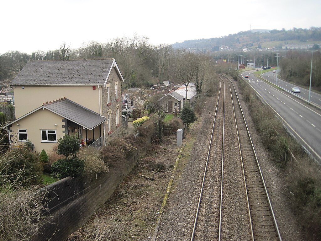
English: Pontypool Road railway station (site), Gwent Opened in 1854 by the Newport Abergavenny and Hereford Railway, later part of the Great Western Railway, this station closed in 1909 when it was replaced by a larger facility of the same name, some 300m behind the camera position. That second station is still in business, but was later called Pontypool & New Inn. View south towards Panteg and Newport. The original line turned right here via Pontypool Clarence Street - all now obliterated by roads. |
| Date | |
| Source | From geograph.org.uk |
| Author | Nigel Thompson |
| Permission (Reusing this file) |
Creative Commons Attribution Share-alike license 2.0 |
| Attribution (required by the license) | Nigel Thompson / Pontypool Road railway station (site), Gwent / |
| Camera location | | View this and other nearby images on: OpenStreetMap |
|---|
,_Gwent_(geograph_4387476).jpg¶ms=051.695599_N_-003.017222_E_globe:Earth_type:camera_source:geograph-osgb36(SO29790014)_heading:225.00&language=en)
| Object location | | View this and other nearby images on: OpenStreetMap |
|---|
,_Gwent_(geograph_4387476).jpg¶ms=051.695140_N_-003.017790_E_globe:Earth_class:object_type:object_source:geograph-osgb36(SO29750009)_heading:225.00&language=en)
Licensing
[edit],_Gwent_(geograph_4387476).jpg&action=edit§ion=2)

|
This image was taken from the Geograph project collection. See this photograph's page on the Geograph website for the photographer's contact details. The copyright on this image is owned by Nigel Thompson and is licensed for reuse under the Creative Commons Attribution-ShareAlike 2.0 license.
|
This file is licensed under the Creative Commons Attribution-Share Alike 2.0 Generic license.
Attribution: Nigel Thompson
- You are free:
- to share – to copy, distribute and transmit the work
- to remix – to adapt the work
- Under the following conditions:
- attribution – You must give appropriate credit, provide a link to the license, and indicate if changes were made. You may do so in any reasonable manner, but not in any way that suggests the licensor endorses you or your use.
- share alike – If you remix, transform, or build upon the material, you must distribute your contributions under the same or compatible license as the original.
File history
Click on a date/time to view the file as it appeared at that time.
| Date/Time | Thumbnail | Dimensions | User | Comment | |
|---|---|---|---|---|---|
| current | 18:27, 3 January 2020 | | 1,600 × 1,200 (454 KB) | Lamberhurst (talk | contribs) | Transferred from geograph.co.uk using [https://tools.wmflabs.org/geograph2commons/ geograph2commons] |
You cannot overwrite this file.
File usage on Commons
The following page uses this file:
,_Gwent_(geograph_4387476).jpg&oldid=645970054)