File:Plattegrond Maastricht, ca 1860-1865 (RAL K 167).jpg
Jump to navigation
Jump to search
Size of this preview: 507 × 599 pixels. Other resolutions: 203 × 240 pixels | 406 × 480 pixels | 650 × 768 pixels | 867 × 1,024 pixels | 2,298 × 2,715 pixels.
Original file (2,298 × 2,715 pixels, file size: 726 KB, MIME type: image/jpeg)
Captions
Captions
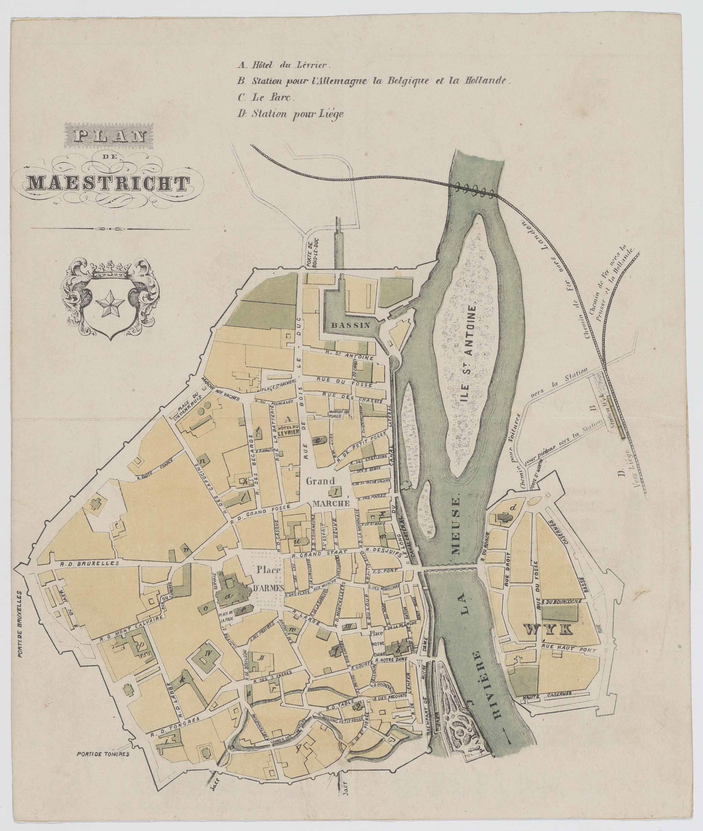
Map of Maastricht, the Netherlands, in the mid-19th c.
Summary
[edit]| Description |
Nederlands: Plattegrond van Maastricht omstreeks 1860. Het kanaal Luik-Maastricht, parallel aan de linker Maasoever, werd voltooid in 1850. De spoorlijnen naar Aken, Hasselt en Luik zijn ingetekend. De spoorlijn naar Luik werd in 1861 in gebruik genomen; de staatsspoorlijn naar Venlo (1865) staat er nog niet op. De kaart is niet helemaal up-to-date: de oude Sint-Maartenskerk in Wyck is nog aanwezig, terwijl deze in 1855 gesloopt was; de nieuwe Sint-Martinuskerk was in 1858 voltooid. Collectie RHCL Maastricht, RAL K 167. |
| Date | between 1861 and 1865 |
| Source | https://beeldbank.rhcl.nl/detail.php?nav_id=3-1&id=5756209&index=427 |
| Author | unknown cartographer |
| Other versions |
_(crop1).jpg)
.jpg&action=edit§ion=1)
Licensing
[edit].jpg&action=edit§ion=2)
|
This work is in the public domain in its country of origin and other countries and areas where the copyright term is the author's life plus 70 years or fewer. | |
| This file has been identified as being free of known restrictions under copyright law, including all related and neighboring rights. | |
File history
Click on a date/time to view the file as it appeared at that time.
| Date/Time | Thumbnail | Dimensions | User | Comment | |
|---|---|---|---|---|---|
| current | 16:55, 14 March 2020 | | 2,298 × 2,715 (726 KB) | Kleon3 (talk | contribs) | Uploaded a work by unknown cartographer from https://beeldbank.rhcl.nl/detail.php?nav_id=3-1&id=5756209&index=427 with UploadWizard |
You cannot overwrite this file.
File usage on Commons
The following 2 pages use this file:
.jpg&redirect=no)
.jpg&oldid=850037798)