File:Plaque in Museum Litovel.jpg
Jump to navigation
Jump to search

Size of this preview: 799 × 277 pixels. Other resolutions: 320 × 111 pixels | 640 × 222 pixels | 1,024 × 355 pixels | 1,280 × 444 pixels | 5,187 × 1,799 pixels.
Original file (5,187 × 1,799 pixels, file size: 2.72 MB, MIME type: image/jpeg)
Captions
Captions
Add a one-line explanation of what this file represents
Summary
[edit]
| Description |
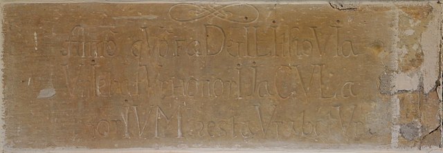
English: A sandstone plaque in Museum Litovel, with the Latin inscription Anno quo foederi Lithovia uniebatutor honori iaculatorium restaurabatur. The plaque is placed in the first floor of the museum left of the entrance into the exhibition halls. The chronogram in the inscription gives the year 1747.
Čeština: Pískovcová deska v Muzeu Litovel s latinským nápisem Anno quo foederi Lithovia uniebatutor honori iaculatorium restaurabatur (česky: V roce, kdy se Litovel sjednotila ve spolku, na počest obnovena). Deska je umístěna v prvním patře muzea nalevo od vstupu do výstavních sálů. Chronogram v nápisu dává rok 1747.
|
| Date | |
| Source | Own work |
| Author | Jan Kameníček |
| Camera location | | View this and other nearby images on: OpenStreetMap |
|---|

|
This file was uploaded during the project of WikiTown Litovel.
|
This photograph was taken with a DSLR from WMCZ's Camera grant.
|
Licensing
[edit]
I, the copyright holder of this work, hereby publish it under the following license:
This file is licensed under the Creative Commons Attribution-Share Alike 4.0 International license.
- You are free:
- to share – to copy, distribute and transmit the work
- to remix – to adapt the work
- Under the following conditions:
- attribution – You must give appropriate credit, provide a link to the license, and indicate if changes were made. You may do so in any reasonable manner, but not in any way that suggests the licensor endorses you or your use.
- share alike – If you remix, transform, or build upon the material, you must distribute your contributions under the same or compatible license as the original.
File history
Click on a date/time to view the file as it appeared at that time.
| Date/Time | Thumbnail | Dimensions | User | Comment | |
|---|---|---|---|---|---|
| current | 20:21, 29 August 2017 | 5,187 × 1,799 (2.72 MB) | Jan.Kamenicek (talk | contribs) | User created page with UploadWizard |
You cannot overwrite this file.
File usage on Commons
The following page uses this file:
File usage on other wikis
The following other wikis use this file:
- Usage on cs.wikipedia.org
Metadata
Categories:
- Plaques in Litovel
- Interior of the Museum Litovel
- Stone plaques in the Czech Republic
- Sandstone inscriptions in the Czech Republic
- Restoration of buildings
- Plaques referencing 1747 in the Czech Republic
- Unorthographic dotted capital "I"
- U as V
- Mixed case in Roman numeral chronograms
- Chronograms in writing in Czechia
- MDCLLVVVVVVVVIIIIIII (numeral)