File:Plan Paris Métro ligne 4 2022.svg
Jump to navigation
Jump to search

Size of this PNG preview of this SVG file: 800 × 256 pixels. Other resolutions: 320 × 102 pixels | 640 × 204 pixels | 1,024 × 327 pixels | 1,280 × 409 pixels | 2,560 × 818 pixels | 2,470 × 789 pixels.
Original file (SVG file, nominally 2,470 × 789 pixels, file size: 171 KB)
Captions
Captions
Add a one-line explanation of what this file represents
Summary
[edit]
| Description |
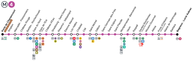
Français : Plan de la ligne 4 du métro de Paris après l'extension sud prévue pour janvier 2022. |
| Date | |
| Source | Own work |
| Author | Chabe01 |
Licensing
[edit]
I, the copyright holder of this work, hereby publish it under the following license:
This file is licensed under the Creative Commons Attribution-Share Alike 4.0 International license.
- You are free:
- to share – to copy, distribute and transmit the work
- to remix – to adapt the work
- Under the following conditions:
- attribution – You must give appropriate credit, provide a link to the license, and indicate if changes were made. You may do so in any reasonable manner, but not in any way that suggests the licensor endorses you or your use.
- share alike – If you remix, transform, or build upon the material, you must distribute your contributions under the same or compatible license as the original.
File history
Click on a date/time to view the file as it appeared at that time.
| Date/Time | Thumbnail | Dimensions | User | Comment | |
|---|---|---|---|---|---|
| current | 01:34, 19 May 2022 | 2,470 × 789 (171 KB) | AlexBurn44 (talk | contribs) | Format | |
| 10:39, 25 August 2021 | 2,477 × 795 (225 KB) | AlexBurn44 (talk | contribs) | + | ||
| 03:54, 20 December 2019 | 2,477 × 795 (227 KB) | AlexBurn44 (talk | contribs) | ++ | ||
| 21:49, 22 October 2019 | 2,477 × 795 (227 KB) | AlexBurn44 (talk | contribs) | Format | ||
| 14:58, 28 October 2018 | 2,477 × 795 (204 KB) | AlexBurn44 (talk | contribs) | Correction | ||
| 14:52, 28 October 2018 | 2,477 × 795 (203 KB) | AlexBurn44 (talk | contribs) | Qualoté graphique | ||
| 14:50, 28 October 2018 | 2,477 × 795 (207 KB) | AlexBurn44 (talk | contribs) | Plan de la ligne vers 2022 | ||
| 14:18, 28 October 2018 | 2,477 × 795 (203 KB) | AlexBurn44 (talk | contribs) | Format | ||
| 00:32, 4 July 2018 | 2,477 × 795 (195 KB) | Chabe01 (talk | contribs) | Mise à jour des noms des nouvelles stations. | ||
| 01:53, 20 February 2018 | 2,365 × 795 (173 KB) | Chabe01 (talk | contribs) | Fichier moins lourd |
You cannot overwrite this file.
File usage on Commons
The following 27 pages use this file:
- User:Chumwa/OgreBot/Potential transport maps/2018 February 10-18
- User:Chumwa/OgreBot/Potential transport maps/2018 February 19-28
- User:Chumwa/OgreBot/Potential transport maps/2018 July 1-10
- User:Chumwa/OgreBot/Potential transport maps/2018 October 21-31
- User:Chumwa/OgreBot/Potential transport maps/2019 December 11-20
- User:Chumwa/OgreBot/Potential transport maps/2019 October 21-31
- User:Chumwa/OgreBot/Public transport information/2018 February 10-18
- User:Chumwa/OgreBot/Public transport information/2018 February 19-28
- User:Chumwa/OgreBot/Public transport information/2018 July 1-10
- User:Chumwa/OgreBot/Public transport information/2018 October 21-31
- User:Chumwa/OgreBot/Public transport information/2019 December 11-20
- User:Chumwa/OgreBot/Public transport information/2019 October 21-31
- User:Chumwa/OgreBot/Public transport information/2021 August 21-31
- User:Chumwa/OgreBot/Public transport information/2022 May 11-20
- User:Chumwa/OgreBot/Transport Maps/2018 February 10-18
- User:Chumwa/OgreBot/Transport Maps/2018 February 19-28
- User:Chumwa/OgreBot/Transport Maps/2018 July 1-10
- User:Chumwa/OgreBot/Transport Maps/2018 October 21-31
- User:Chumwa/OgreBot/Transport Maps/2019 December 11-20
- User:Chumwa/OgreBot/Transport Maps/2019 October 21-31
- User:Chumwa/OgreBot/Transport Maps/2021 August 21-31
- User:Chumwa/OgreBot/Transport Maps/2022 May 11-20
- User:Chumwa/OgreBot/Travel and communication maps/2018 February 10-18
- User:Chumwa/OgreBot/Travel and communication maps/2018 February 19-28
- User:Chumwa/OgreBot/Travel and communication maps/2018 July 1-10
- User:Chumwa/OgreBot/Travel and communication maps/2018 October 21-31
- File:Plan Paris Métro ligne 4 2020.svg (file redirect)