File:Pigeon Island (Houtman Abrolhos).svg
From Wikimedia Commons, the free media repository
Jump to navigation
Jump to search

Size of this PNG preview of this SVG file: 532 × 599 pixels. Other resolutions: 213 × 240 pixels | 426 × 480 pixels | 682 × 768 pixels | 909 × 1,024 pixels | 1,818 × 2,048 pixels | 1,179 × 1,328 pixels.
Original file (SVG file, nominally 1,179 × 1,328 pixels, file size: 62 KB)
File information
Structured data
Captions
Captions
Add a one-line explanation of what this file represents
| DescriptionPigeon Island (Houtman Abrolhos).svg |
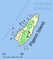
This is a map of Pigeon Island in the Houtman Abrolhos off the coast of Western Australia. Areas shown in yellow are sparsely vegetated or unvegetated. Areas in green have reasonably dense vegetation. Spatial information was traced from 50 centimetre resolution satellite imagery obtained using Google Earth, and can be assumed to be quite accurate. The buildings and jetties were also traced from satellite imagery, but identification of individual buildings was problematic, and therefore probably inaccurate; these features should therefore be treated as indicative only of the spread and density of settlement. |
||
| Date | |||
| Source | Own work | ||
| Author | Hesperian | ||
| Permission (Reusing this file) |
I, the copyright holder of this work, hereby publish it under the following licenses: This file is licensed under the Creative Commons Attribution-Share Alike 4.0 International, 3.0 Unported, 2.5 Generic, 2.0 Generic and 1.0 Generic license.
You may select the license of your choice. |
File history
Click on a date/time to view the file as it appeared at that time.
| Date/Time | Thumbnail | Dimensions | User | Comment | |
|---|---|---|---|---|---|
| current | 03:24, 11 May 2008 |  | 1,179 × 1,328 (62 KB) | Hesperian (talk | contribs) | narrower stroke for coast, and trying to fix line spacing problem - it seems that Mediawiki' svg thumbing, nor firefox, properly handles Inkscape's text spacing properly - not sure who's to blame. |
| 13:27, 10 May 2008 |  | 1,179 × 1,328 (62 KB) | Hesperian (talk | contribs) | {{Information |Description=This is a map of Pigeon Island in the Houtman Abrolhos off the coast of Western Australia. Areas shown in yellow are sparsely vegetated or unvegetated. Areas in green have reasonably |
You cannot overwrite this file.
File usage on Commons
There are no pages that use this file.
File usage on other wikis
The following other wikis use this file:
- Usage on de.wikipedia.org
- Usage on en.wikipedia.org
- Usage on it.wikipedia.org
