File:Ph fil central visayas.png
Jump to navigation
Jump to search

Size of this preview: 384 × 599 pixels. Other resolutions: 154 × 240 pixels | 308 × 480 pixels | 492 × 768 pixels | 656 × 1,024 pixels | 2,000 × 3,120 pixels.
Original file (2,000 × 3,120 pixels, file size: 137 KB, MIME type: image/png)
Captions
Captions
Add a one-line explanation of what this file represents
Summary
[edit]
| Description |
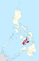
English: Location of Central Visayas region in the Philippines.
Filipino: Kinaroroonan ng rehiyon ng Gitnang Visayas sa Pilipinas. |
| Date | |
| Source |
BlankMap-Philippines.png by User:TheCoffee
|
| Author | Roel Balingit |
Licensing
[edit]
I, the copyright holder of this work, hereby publish it under the following license:
This file is licensed under the Creative Commons Attribution-Share Alike 3.0 Unported license.
- You are free:
- to share – to copy, distribute and transmit the work
- to remix – to adapt the work
- Under the following conditions:
- attribution – You must give appropriate credit, provide a link to the license, and indicate if changes were made. You may do so in any reasonable manner, but not in any way that suggests the licensor endorses you or your use.
- share alike – If you remix, transform, or build upon the material, you must distribute your contributions under the same or compatible license as the original.

|
If you choose to use this work under the Creative Commons license stated above, the author, Roel Balingit (Namayan), would like you to attribute the work to him (among other requirements such as indicating that the work is licensed under the Creative Commons) with the following text or similar:
© Roel Balingit, 2012.
His name should be a link to the Wikimedia Commons userpage Namayan. If a link is not possible, then the url should be placed in parentheses after the name. If the work has been substantially altered by other people (see the File history section below), then this particular attribution requirement is waived, which means you can attribute the work in any reasonable manner. This attribution requirement is provided pursuant to the Creative Commons Attribution mechanism where "you must attribute the work in the manner specified by the author or licensor (but not in any way that suggests that they endorse you or your use of the work)." (See "Attribution" in the Creative Commons website.)
|
File history
Click on a date/time to view the file as it appeared at that time.
| Date/Time | Thumbnail | Dimensions | User | Comment | |
|---|---|---|---|---|---|
| current | 03:05, 8 September 2017 | | 2,000 × 3,120 (137 KB) | WayKurat (talk | contribs) | Reverted to version as of 13:53, 9 August 2017 (UTC) |
| 03:51, 1 September 2017 |  | 2,000 × 3,120 (136 KB) | Tekken Network (talk | contribs) | Reverted to version as of 10:10, 5 June 2015 (UTC) | |
| 13:53, 9 August 2017 |  | 2,000 × 3,120 (137 KB) | Hariboneagle927 (talk | contribs) | Reverted to version as of 03:20, 15 August 2012 (UTC) NIR is abolished | |
| 10:10, 5 June 2015 |  | 2,000 × 3,120 (136 KB) | Namayan (talk | contribs) | Negros Oriental moved to Negros Island Region | |
| 03:22, 15 August 2012 |  | 2,000 × 3,120 (137 KB) | Namayan (talk | contribs) |
You cannot overwrite this file.
File usage on Commons
The following 3 pages use this file:
File usage on other wikis
The following other wikis use this file:
- Usage on af.wikipedia.org
- Usage on an.wikipedia.org
- Usage on ca.wikipedia.org
- Usage on de.wikipedia.org
- Usage on en.wikipedia.org
- Cebu Strait
- Pilar, Cebu
- Ronda, Cebu
- San Fernando, Cebu
- Sogod, Cebu
- Tabogon
- Tabuelan
- Enrique Villanueva
- Lazi, Siquijor
- Maria, Siquijor
- Mabini, Bohol
- San Isidro, Bohol
- San Miguel, Bohol
- Sevilla, Bohol
- Sierra Bullones
- Trinidad, Bohol
- Hinagdanan Cave
- Himontagon Hills
- Poro Island
- Colon Street
- Hilutangan Channel
- Magellan Bay
- Central Cebu Protected Landscape
- Mount Lantoy
- Kan-irag Nature Park
- Nalusuan
- Silmugi River
- Guadalupe Mabugnao Mainit Hot Spring National Park
- Doong
- Jilantagaan
- Botigues
- Mambacayao Daku
- Lipayran
- Silion
- Kinatarkan
- Template:CVisayas-geo-stub
- Mandani Bay
- Nasingin Island
- Usage on hr.wikipedia.org
- Usage on ilo.wikipedia.org
- Usage on no.wikipedia.org
- Usage on ro.wikipedia.org
- Usage on ru.wikipedia.org
- Usage on simple.wikipedia.org
View more global usage of this file.