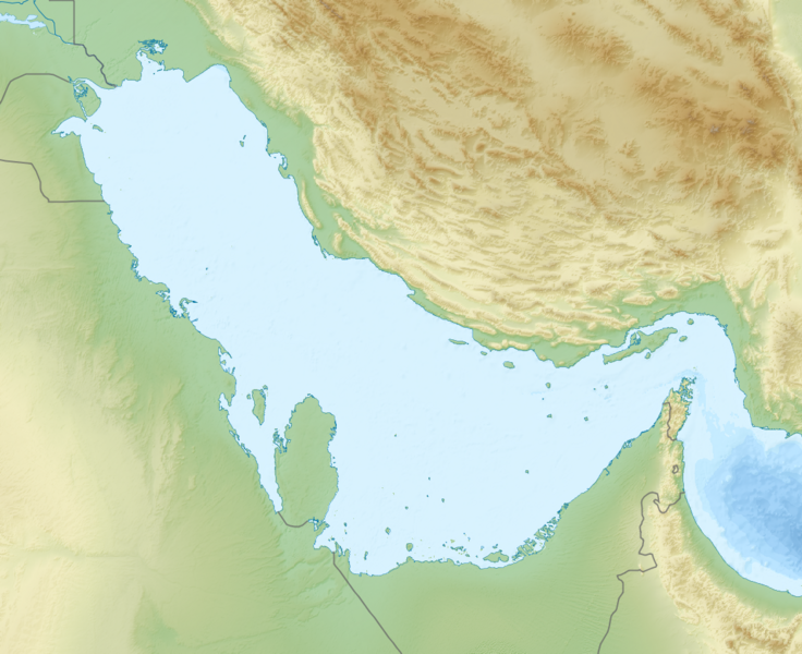
File:Persian Gulf relief location map.png
From Wikimedia Commons, the free media repository
Jump to navigation
Jump to search

Size of this preview: 736 × 600 pixels. Other resolutions: 295 × 240 pixels | 589 × 480 pixels | 943 × 768 pixels | 1,100 × 896 pixels.
Original file (1,100 × 896 pixels, file size: 1.22 MB, MIME type: image/png)
File information
Structured data
Captions
Captions
Add a one-line explanation of what this file represents
Summary
[edit]| DescriptionPersian Gulf relief location map.png |
English: Location map of the Persian Gulf.
Equirectangular projection. Strechted by 112.0%. Geographic limits of the map:
Relief: SRTM30plus. Coastline, borders, rivers etc: Made with Natural Earth. Free vector and raster map data @ naturalearthdata.com. |
| Date | |
| Source | Own work |
| Author | Uwe Dedering |
Licensing
[edit]I, the copyright holder of this work, hereby publish it under the following licenses:
This file is licensed under the Creative Commons Attribution-Share Alike 3.0 Unported license.
- You are free:
- to share – to copy, distribute and transmit the work
- to remix – to adapt the work
- Under the following conditions:
- attribution – You must give appropriate credit, provide a link to the license, and indicate if changes were made. You may do so in any reasonable manner, but not in any way that suggests the licensor endorses you or your use.
- share alike – If you remix, transform, or build upon the material, you must distribute your contributions under the same or compatible license as the original.

|
Permission is granted to copy, distribute and/or modify this document under the terms of the GNU Free Documentation License, Version 1.2 or any later version published by the Free Software Foundation; with no Invariant Sections, no Front-Cover Texts, and no Back-Cover Texts. A copy of the license is included in the section entitled GNU Free Documentation License.http://www.gnu.org/copyleft/fdl.htmlGFDLGNU Free Documentation Licensetruetrue |
You may select the license of your choice.
File history
Click on a date/time to view the file as it appeared at that time.
| Date/Time | Thumbnail | Dimensions | User | Comment | |
|---|---|---|---|---|---|
| current | 13:41, 8 September 2010 |  | 1,100 × 896 (1.22 MB) | Uwe Dedering (talk | contribs) | {{Information |Description={{en|1= Location map of the Persian Gulf. Equirectangular projection. Strechted by 112.0%. Geographic limits of the map: * N: 31.0° N * S: 23.0° N * W: 47.0° E * E: 58.0° E Relief: [ftp://topex.ucsd.edu/pub/srtm30_plus/sr |
You cannot overwrite this file.
File usage on Commons
There are no pages that use this file.
File usage on other wikis
The following other wikis use this file:
- Usage on ar.wikipedia.org
- Usage on azb.wikipedia.org
- Usage on az.wikipedia.org
- Usage on bn.wikipedia.org
- Usage on ceb.wikipedia.org
- Usage on cs.wikipedia.org
- Usage on de.wikipedia.org
- Wikipedia:Kartenwerkstatt/Positionskarten/Andere
- Benutzer:Uwe Dedering
- Vorlage:Positionskarte Persischer Golf
- Wikipedia:Kartenwerkstatt/Archiv/2010-10
- Wikipedia:Kartenwerkstatt/Archiv/2022-02
- Formel-4-Meisterschaft der Vereinigten Arabischen Emirate 2023
- Formula Regional Middle East Championship 2023
- Usage on en.wikipedia.org
- Abadan, Iran
- Manama
- Kuwait City
- Dubai International Airport
- Umm Qasr
- Bushehr
- Dubai
- Al Ain
- Ubaid period
- Kuwait International Airport
- Zayed International Airport
- Nahwa
- Kish Island
- Greater and Lesser Tunbs
- Hendurabi
- Abu Musa
- King Abdulaziz Air Base
- Bandar Lengeh
- Wadi Qada'ah
- Khasab
- Al-Faw
- Lavan Island
- Kharg Island
- Qeshm Island
- Jebel Hafeet
- Larak Island
- Ajman
View more global usage of this file.