File:Panorámica de la Reserva Natural de los Barruecos (Malpartida de Cáceres).jpg

Original file (5,000 × 614 pixels, file size: 592 KB, MIME type: image/jpeg)
Captions
Captions
Summary
[edit].jpg&action=edit§ion=1)
| Description |
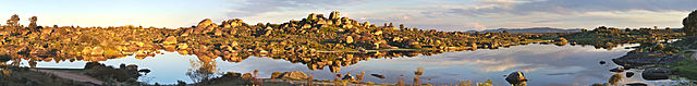
Español: Imagen de las Peñas del Tesoro a orillas del Charco del Barrueco de Abajo. Imagen formada a partir de 6 fotografías unidas usando el software Hugin. |
| Date | |
| Source | Own work |
| Author | Mario Modesto Mata |
| Permission (Reusing this file) |
Summary:
In using this image or any subsequent derivatives of it, you are required to release the image under the same license. As such, any reproduction of this image, in any medium, must appear with a copy of, or full URL of the license. Attribution of this image to the author (Mario Modesto Mata) is required in a prominent location near to the image. No other conditions may be added to, or removed from this license without the permission of the author and copyright holder.Please review the full license requirements carefully before using this image. If you would like to clarify the terms of the license or negotiate less restrictive commercial licensing outside of the bounds of GFDL/CC-BY-SA, please contact me by email, or if you don't have a Wikipedia account you can leave a message on my talk page with your contact details and your request.
 |
| Camera location | | View this and other nearby images on: OpenStreetMap |
|---|
.jpg¶ms=039.424795_N_-006.499735_E_globe:Earth_type:camera__&language=en)
Licensing
[edit].jpg&action=edit§ion=2)
- You are free:
- to share – to copy, distribute and transmit the work
- to remix – to adapt the work
- Under the following conditions:
- attribution – You must give appropriate credit, provide a link to the license, and indicate if changes were made. You may do so in any reasonable manner, but not in any way that suggests the licensor endorses you or your use.
- share alike – If you remix, transform, or build upon the material, you must distribute your contributions under the same or compatible license as the original.
File history
Click on a date/time to view the file as it appeared at that time.
| Date/Time | Thumbnail | Dimensions | User | Comment | |
|---|---|---|---|---|---|
| current | 13:55, 10 April 2015 | 5,000 × 614 (592 KB) | Mario modesto (talk | contribs) | User created page with UploadWizard |
You cannot overwrite this file.
File usage on Commons
There are no pages that use this file.
File usage on other wikis
The following other wikis use this file:
- Usage on ast.wikipedia.org
- Usage on ca.wikipedia.org
- Usage on es.wikipedia.org
.jpg&oldid=669664278)