File:Płock location map.png
Jump to navigation
Jump to search

Size of this preview: 537 × 600 pixels. Other resolutions: 215 × 240 pixels | 430 × 480 pixels | 855 × 955 pixels.
Original file (855 × 955 pixels, file size: 483 KB, MIME type: image/png)
Captions
Captions
Add a one-line explanation of what this file represents
| Description |
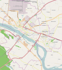
Location map of Płock, Poland This map of Płock was created from OpenStreetMap project data, collected by the community. This map may be incomplete, and may contain errors. Don't rely solely on it for navigation. |
|||||||||
| Date | ||||||||||
| Source | You may find a page on the OpenStreetMap wiki page for Płock | |||||||||
| Creator |
OpenStreetMap contributors OpenStreetMap contributors |
|||||||||
| Permission (Reusing this file) |
OpenStreetMap data is available under the Open Database License (details). Map tiles are licensed under the Creative Commons Attribution-ShareAlike 2.0 license (CC-BY-SA 2.0).
This file is licensed under the Creative Commons Attribution-Share Alike 2.0 Generic license.
|
|||||||||
| Geotemporal data | ||||||||||
| Bounding box |
|
|||||||||
| Georeferencing | If inappropriate please set warp_status = skip to hide. | |||||||||
File history
Click on a date/time to view the file as it appeared at that time.
| Date/Time | Thumbnail | Dimensions | User | Comment | |
|---|---|---|---|---|---|
| current | 17:50, 3 November 2013 | | 855 × 955 (483 KB) | Powerek38 (talk | contribs) | {{OpenStreetMap |name=Płock |location=Płock |description=Location map of Płock, Poland |top=52.597 |bottom=52.474 |left=19.624 |right=19.806 |date=2013-11-03 |authors=OpenStreetMap contributors |other_versions= }} Category:Płock |
You cannot overwrite this file.
File usage on Commons
There are no pages that use this file.
File usage on other wikis
The following other wikis use this file:
- Usage on fr.wikipedia.org
- Usage on pl.wikipedia.org
- Longinus
- Świątynia Miłosierdzia i Miłości w Płocku
- Liceum Ogólnokształcące im. Marszałka Stanisława Małachowskiego w Płocku
- Orlen
- Chorągiew Mazowiecka ZHP
- Bazylika katedralna Wniebowzięcia Najświętszej Maryi Panny w Płocku
- Kolegiata św. Bartłomieja w Płocku
- Sanktuarium Miłosierdzia Bożego w Płocku
- Miejski Ogród Zoologiczny w Płocku
- Muzeum Diecezjalne w Płocku
- Muzeum Mazowieckie w Płocku
- Liceum Ogólnokształcące im. Władysława Jagiełły w Płocku
- Kościół św. Stanisława Kostki w Płocku
- Radziwie (Płock)
- Stare Miasto (Płock)
- Borowiczki
- Zielony Jar
- Płock (stacja kolejowa)
- Imielnica (Płock)
- Lotnisko Płock
- Osiedle Łukasiewicza (Płock)
- Osiedle Tysiąclecia (Płock)
- Towarzystwo Naukowe Płockie
- Wyszogrodzka (Płock)
- Winiary (Płock)
- Trzepowo (Płock)
- Podolszyce Północ
- Parafia Świętego Krzyża w Płocku
- Podolszyce Południe
- Podolszyce
- Międzytorze (Płock)
- Kościół św. Benedykta w Płocku
- Kościół św. Dominika w Płocku
- Kościół św. Jana Chrzciciela w Płocku
- Kościół Miłosierdzia Bożego w Płocku
- Dworcowa (Płock)
- Skarpa (Płock)
- Pradolina Wisły (Płock)
- Góry (Płock)
- Miodowa (Płock)
- Ciechomice (Płock)
- Osiedle Kochanowskiego (Płock)
- Kolegialna (Płock)
- Szkoła Wyższa im. Pawła Włodkowica w Płocku
- Biblioteka im. Zielińskich Towarzystwa Naukowego Płockiego
- Kościół św. Aleksego w Płocku
- Cerkiew Przemienienia Pańskiego w Płocku
- Mała Synagoga w Płocku
- Stadion im. Kazimierza Górskiego w Płocku
View more global usage of this file.