File:OttomanEmpireIn1683-fr.svg

Original file (SVG file, nominally 1,966 × 1,850 pixels, file size: 302 KB)
Captions
Captions
Summary
[edit]| DescriptionOttomanEmpireIn1683-fr.svg |
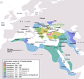
English: Map depicting the Ottoman Empire at its greatest extent, in 1683. Türkçe: Osmanlı İmparatorluğu en geniş sınırları (1683)
|
||
| Date | (UTC) | ||
| Source |
This file was derived from: OttomanEmpireIn1683.png: |
||
| Author |
|
||
| Other versions |
[edit]
|
| This is a retouched picture, which means that it has been digitally altered from its original version. Modifications: Turned into SVG text and translated to French.. The original can be viewed here: OttomanEmpireIn1683.png:
|
Licensing
[edit]| Public domainPublic domainfalsefalse |
| I, the copyright holder of this work, release this work into the public domain. This applies worldwide. In some countries this may not be legally possible; if so: I grant anyone the right to use this work for any purpose, without any conditions, unless such conditions are required by law. |
Original upload log
[edit]This image is a derivative work of the following images:
- File:OttomanEmpireIn1683.png licensed with PD-self
- 2013-03-06T17:58:17Z DragonTiger23 1966x1850 (347599 Bytes) Reverted to version as of 23:11, 10 December 2010 Returned the map to its original appearance.
- 2012-03-04T19:47:02Z Spiridon Ion Cepleanu 637x599 (175690 Bytes) Little changes since Hans-Erich Stier (ed.), Grosser Atlas zur Weltgeschichte, Westermann 1895, ISBN 3-14-10 0919-8, pp. 103, 103 & 112.
- 2010-12-10T23:11:12Z Lambiam 1966x1850 (347599 Bytes) Scale indicator more up to actual scale
- 2010-11-16T18:53:38Z Hamelin de Guettelet 1966x1850 (375469 Bytes) {{Information |Description= Rhodes et autres îles ne sont prises aux Hospitaliers que le 1 janvier 1523 |Source={{own}} |Date=16 novembre 2010 |Author=[[User:Hamelin de Guettelet|Hamelin de Guettelet]] |Permission= |other_ve
- 2010-04-01T10:40:16Z Nedim Ardoğa 1966x1850 (334406 Bytes) Reverted to version as of 07:37, 10 March 2010
- 2010-03-31T12:11:05Z Bahramm 2 637x599 (168664 Bytes) Reverted to version as of 14:12, 1 March 2010
- 2010-03-10T07:37:04Z Nedim Ardoğa 1966x1850 (334406 Bytes) Reverted to version as of 20:35, 21 February 2010
- 2010-03-01T14:12:01Z Bahramm 2 637x599 (168664 Bytes) Reverted to version as of 18:51, 24 January 2010
- 2010-02-21T20:35:06Z Nedim Ardoğa 1966x1850 (334406 Bytes) Reverted to version as of 15:12, 26 March 2007
- 2010-01-24T18:51:26Z Persia2099 637x599 (168664 Bytes) Minor Update
- 2007-03-26T15:12:25Z AtilimGunesBaydin 1966x1850 (334406 Bytes) Updated Ionian Islands.
- 2007-03-15T01:25:07Z Stevanb 1966x1850 (310597 Bytes) Corrected some error. Very important (historical) Ottoman "city" in Balkan area is Prizren - on the map marked as Kosovo. Kosovo is region, Prizren is town (Ottoman "city").
- 2007-02-25T16:28:59Z AtilimGunesBaydin 1966x1850 (334954 Bytes) Minor update.
- 2007-02-18T02:34:25Z AtilimGunesBaydin 1966x1850 (335164 Bytes) Update territories, some city locations and labels.
- 2007-02-14T23:50:38Z AtilimGunesBaydin 1940x1500 (313464 Bytes) Minor fixes, updated some borders and the color scheme.
- 2006-12-23T00:55:59Z AtilimGunesBaydin 1684x1348 (289614 Bytes) Added more labels.
- 2006-12-21T17:47:33Z AtilimGunesBaydin 1684x1347 (249515 Bytes) {{Information |Description=Map depicting the [[:en:Ottoman Empire|Ottoman Empire]] at its greatest extent, in 1683. |Source=Self drawn, based on information mainly compiled from [[:Image:Ottoman 1683.png]], [http://fs.hunting
Uploaded with derivativeFX
File history
Click on a date/time to view the file as it appeared at that time.
| Date/Time | Thumbnail | Dimensions | User | Comment | |
|---|---|---|---|---|---|
| current | 09:43, 20 October 2023 |  | 1,966 × 1,850 (302 KB) | Guglani (talk | contribs) | File uploaded using svgtranslate tool (https://svgtranslate.toolforge.org/). Added translation for pa-guru. |
| 09:32, 20 October 2023 |  | 1,966 × 1,850 (302 KB) | Guglani (talk | contribs) | File uploaded using svgtranslate tool (https://svgtranslate.toolforge.org/). Added translation for pa-guru. | |
| 09:27, 11 July 2013 |  | 1,966 × 1,850 (255 KB) | Flappiefh (talk | contribs) | == {{int:filedesc}} == {{Information |Description={{en|Map depicting the Ottoman Empire at its greatest extent, in 1683.}} {{tr|Osmanlı İmparatorluğu en geniş sınırları (1683)}} |Source={{D... |
You cannot overwrite this file.
File usage on Commons
The following 10 pages use this file:
- File:Japanese-Ottoman1683.PNG
- File:OttomanEmpireIn1683-cy.svg
- File:OttomanEmpireIn1683-fr.svg
- File:OttomanEmpireIn1683-wl.png
- File:OttomanEmpireIn1683-zh-classical.png
- File:OttomanEmpireIn1683-zh-hans.svg
- File:OttomanEmpireIn1683.png
- File:OttomanEmpireIn1683 ar.png
- File:OttomanEmpireIn1683tr.png
- Template:Other Versions/OttomanEmpireIn1683
File usage on other wikis
The following other wikis use this file:
- Usage on el.wikipedia.org
- Usage on eo.wikinews.org
- Usage on fr.wikipedia.org
- Usage on pa.wikipedia.org
Metadata
This file contains additional information such as Exif metadata which may have been added by the digital camera, scanner, or software program used to create or digitize it. If the file has been modified from its original state, some details such as the timestamp may not fully reflect those of the original file. The timestamp is only as accurate as the clock in the camera, and it may be completely wrong.
| Width | 1966 |
|---|---|
| Height | 1850 |


