File:Ordnance Survey Drawings - Woodstock (OSD 162).jpg
Jump to navigation
Jump to search

Size of this preview: 800 × 545 pixels. Other resolutions: 320 × 218 pixels | 640 × 436 pixels | 1,024 × 698 pixels | 1,280 × 872 pixels | 2,560 × 1,745 pixels | 4,000 × 2,726 pixels.
Original file (4,000 × 2,726 pixels, file size: 4.16 MB, MIME type: image/jpeg)
Captions
Captions
Add a one-line explanation of what this file represents
| Woodstock (OSD 162)
|
|||||
|---|---|---|---|---|---|
| Artist |
Stanley, William - Draughtsman |
.jpg) | |||
| Title |
Ordnance Survey Drawings: Woodstock (OSD 162) |
||||
| Object type |
manuscript map |
||||
| Description |
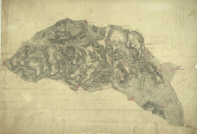
 Centre of map shown on a map of England
English: The map of the area surrounding the Royal Wychwood Forest and Oxford was drawn by teaching draughtsman at the Tower of London, William Stanley. After inaccuracies were found in the plan during routine checks in 1820, Stanley hastened to explain that the employment by the Board of Ordnance of local civilian surveyors "of various abilities" to carry out much of the mapping meant that accuracy was often sacrificed for speed as these civilian personnel were paid according to the number of miles surveyed and drawn. An ochre-coloured turnpike road forms a boundary from Shipton Down at the top left of the map to Yarnton at the centre right. The cumulative mileage appears alongside the route in figures. The close attention Stanley pays to communication routes emphasises the military focus of these studies..
This image has been georeferenced.
|
||||
| Language |
English |
||||
| Date | 1811 | ||||
| Medium | Pen and ink on paper | ||||
| Dimensions | height: 260 mm (10.23 in); width: 360 mm (14.17 in) | ||||
| Collection | |||||
| Accession number |
Maps OSD 162 |
||||
| Credit line | British Library | ||||
| Notes |
Scale 2 inches : 1 mile (1:31680). Please note that the British Library provides these digital files "as-is"; materials will not be rephotographed under this programme. If resupply of files is required, the requestor will be required to purchase them at the standard rate. |
||||
| References |
http://www.bl.uk/onlinegallery/onlineex/ordsurvdraw/w/002osd000000009u00115000.html (English) |
||||
| Source/Photographer |
|
||||
| Permission (Reusing this file) |
|
||||


_(St_Edwards_Crown).svg)
.jpg¶ms=51.817343_N_-1.446957_E_)
.jpg¶ms=51.719728_N_-1.660512_E_)
.jpg¶ms=51.914958_N_-1.233401_E_)
.jpg¶ms=51.887713_N_-1.660512_E_)
.jpg¶ms=51.719728_N_-1.629401_E_)
.jpg¶ms=51.746974_N_-1.233401_E_)
.jpg¶ms=51.914958_N_-1.264512_E_)
File history
Click on a date/time to view the file as it appeared at that time.
| Date/Time | Thumbnail | Dimensions | User | Comment | |
|---|---|---|---|---|---|
| current | 08:17, 26 September 2013 | | 4,000 × 2,726 (4.16 MB) | LibraryBot (talk | contribs) | {{subst:User:Andrew Gray/OSD|ID= 002OSD000000009U00115000 |OSD_NUM= OSD 162 |MEDIUM= Pen and ink on paper |TITLE= Woodstock |CREATOR= Stanley, William - Draughtsman |YEAR= 1811 |DESCRIPTION= The map of the area surrounding the Royal Wychwood Forest and... |
You cannot overwrite this file.
File usage on Commons
The following page uses this file:
File usage on other wikis
The following other wikis use this file:
- Usage on www.wikidata.org
.jpg&oldid=906176285)