File:Ordnance Survey Drawings - Dover, Kent (OSD 106E).jpg

Original file (4,000 × 2,223 pixels, file size: 2.39 MB, MIME type: image/jpeg)
Captions
Captions
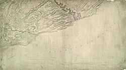
| Dover (Kent) (OSD 106E)
|
||||||||||||||||||||||||
|---|---|---|---|---|---|---|---|---|---|---|---|---|---|---|---|---|---|---|---|---|---|---|---|---|
| Title |
Ordnance Survey Drawings: Dover, Kent (OSD 106E) |
|||||||||||||||||||||||
| Object type |
manuscript map |
|||||||||||||||||||||||
| Description |
English: The cliffs of Dover are shown almost pictorially on this plan, with dark striations indicating steepness. Relief is shown elsewhere by shading and interlining ('hachuring'). Field boundaries are observed. The sandy coast is represented by a speckled pattern and grassland by a green wash. Dover Castle is seen in plan, with dark hachure lines depicting the steep underlying rocks. The castle, known as the 'Key to England', was a site of unique strategic importance, affording the shortest crossing point of the English Channel to continental Europe. Its defences were improved during the Napoleonic conflicts. Special tunnels were even bored beneath the keep for emergency entrance and exit. This drawing was surveyed while the war was at its most ferocious, yet no batteries are recorded..
This image has been georeferenced.
|
|||||||||||||||||||||||
| Language |
English |
|||||||||||||||||||||||
| Date |
1797 date QS:P571,+1797-00-00T00:00:00Z/9 |
|||||||||||||||||||||||
| Medium | Pen and ink on paper | |||||||||||||||||||||||
| Dimensions |
height: 310 mm (12.20 in); width: 540 mm (21.25 in) dimensions QS:P2048,310U174789 dimensions QS:P2049,540U174789 |
|||||||||||||||||||||||
| Collection |
institution QS:P195,Q23308 |
|||||||||||||||||||||||
| Accession number |
Maps OSD 106E |
|||||||||||||||||||||||
| Credit line | British Library | |||||||||||||||||||||||
| Notes |
Scale 3 inches : 1 mile (1:21120). Please note that the British Library provides these digital files "as-is"; materials will not be rephotographed under this programme. If resupply of files is required, the requestor will be required to purchase them at the standard rate. |
|||||||||||||||||||||||
| References |
http://www.bl.uk/onlinegallery/onlineex/ordsurvdraw/d/002osd000000017u00365000.html (English) |
|||||||||||||||||||||||
| Source/Photographer |
|
|||||||||||||||||||||||
| Permission (Reusing this file) |
|
|||||||||||||||||||||||
File history
Click on a date/time to view the file as it appeared at that time.
| Date/Time | Thumbnail | Dimensions | User | Comment | |
|---|---|---|---|---|---|
| current | 21:39, 27 September 2013 |  | 4,000 × 2,223 (2.39 MB) | LibraryBot (talk | contribs) | {{subst:User:Andrew Gray/OSD|ID= 002OSD000000017U00365000 |OSD_NUM= OSD 106E |MEDIUM= Pen and ink on paper |TITLE= Dover, Kent |CREATOR= |YEAR= 1797 |DESCRIPTION= The cliffs of Dover are shown almost pictorially on this plan, with dark striations indi... |
You cannot overwrite this file.
File usage on Commons
The following page uses this file:
File usage on other wikis
The following other wikis use this file:
- Usage on www.wikidata.org
- Images from the British Library
- Uploaded by the British Library
- Maps with links to BL Georeferencer
- OGL v1.0
- Artworks with known accession number
- Artworks with Wikidata item
- Artworks with Wikidata item missing genre
- Artworks with Wikidata item missing medium
- Artworks digital representation of unknown type of work
- British Library images not yet checked
- OSD-fix
- Files with no machine-readable author


