File:Ordnance Survey Drawings - Axbridge (OSD 49).jpg

Original file (5,056 × 3,747 pixels, file size: 5.31 MB, MIME type: image/jpeg)
Captions
Captions
| Axbridge (OSD 49)
|
||||||||||||||||||||||||
|---|---|---|---|---|---|---|---|---|---|---|---|---|---|---|---|---|---|---|---|---|---|---|---|---|
| Title |
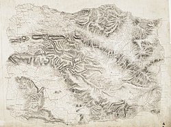
Ordnance Survey Drawings: Axbridge (OSD 49) |
|||||||||||||||||||||||
| Object type |
manuscript map |
|||||||||||||||||||||||
| Description |
English: This drawing covers the Mendip Hills, from Wrington to Wells. Pencil rays extend from the left of the map towards Red Hill, on the right, and Mark and Tillham, on the bottom right. The draughtsman used these lines to measure relative distance and to plot locations by triangulation. Masberry Castle is shown in the bottom right, on top of a hill whose steepness is indicated by soft brushwork interlining ('hachuring'). The castle path joins the main turnpike road, whose length is annotated at intervals of one mile. Many field boundaries are marked in red, denoting stone walls rather than corrections in this case..
This image has been georeferenced.
|
|||||||||||||||||||||||
| Language |
English |
|||||||||||||||||||||||
| Date |
1811 date QS:P571,+1811-00-00T00:00:00Z/9 |
|||||||||||||||||||||||
| Medium | Pen and ink on paper | |||||||||||||||||||||||
| Dimensions |
height: 290 mm (11.41 in); width: 400 mm (15.74 in) dimensions QS:P2048,290U174789 dimensions QS:P2049,400U174789 |
|||||||||||||||||||||||
| Collection |
institution QS:P195,Q23308 |
|||||||||||||||||||||||
| Accession number |
Maps OSD 49 |
|||||||||||||||||||||||
| Credit line | British Library | |||||||||||||||||||||||
| Notes |
Scale 2 inches : 1 mile ( 1: 31680). Please note that the British Library provides these digital files "as-is"; materials will not be rephotographed under this programme. If resupply of files is required, the requestor will be required to purchase them at the standard rate. |
|||||||||||||||||||||||
| References |
http://www.bl.uk/onlinegallery/onlineex/ordsurvdraw/a/002osd000000007u00034000.html (English) |
|||||||||||||||||||||||
| Source/Photographer |
|
|||||||||||||||||||||||
| Permission (Reusing this file) |
|
|||||||||||||||||||||||
File history
Click on a date/time to view the file as it appeared at that time.
| Date/Time | Thumbnail | Dimensions | User | Comment | |
|---|---|---|---|---|---|
| current | 21:37, 26 September 2013 |  | 5,056 × 3,747 (5.31 MB) | LibraryBot (talk | contribs) | {{subst:User:Andrew Gray/OSD|ID= 002OSD000000007U00034000 |OSD_NUM= OSD 49 |MEDIUM= Pen and ink on paper |TITLE= Axbridge |CREATOR= |YEAR= 1811 |DESCRIPTION= This drawing covers the Mendip Hills, from Wrington to Wells. Pencil rays extend from the lef... |
You cannot overwrite this file.
File usage on Commons
The following page uses this file:
File usage on other wikis
The following other wikis use this file:
- Usage on www.wikidata.org
Metadata
This file contains additional information such as Exif metadata which may have been added by the digital camera, scanner, or software program used to create or digitize it. If the file has been modified from its original state, some details such as the timestamp may not fully reflect those of the original file. The timestamp is only as accurate as the clock in the camera, and it may be completely wrong.
| Image title |
|
|---|---|
| Camera manufacturer | Phase One |
| Camera model | P65+ |
| Author | 11861 |
| Exposure time | 40,370/2,422,199 sec (0.016666673547467) |
| F-number | f/12 |
| ISO speed rating | 50 |
| Date and time of data generation | 14:40, 6 January 2012 |
| Lens focal length | 55 mm |
| Headline | Maps OSD 49 |
| Credit/Provider | The British Library |
| Source | The British Library |
| Short title |
|
| Copyright holder |
|
| Usage terms |
|
| City shown | London |
| Width | 8,814 px |
| Height | 6,231 px |
| Bits per component |
|
| Compression scheme | Uncompressed |
| Pixel composition | RGB |
| Orientation | Normal |
| Number of components | 3 |
| Horizontal resolution | 200 dpi |
| Vertical resolution | 200 dpi |
| Data arrangement | chunky format |
| Software used | Adobe Photoshop CS3 Windows |
| File change date and time | 11:20, 16 January 2012 |
| Exposure Program | Manual |
| Exif version | 2.2 |
| Date and time of digitizing | 14:40, 6 January 2012 |
| APEX shutter speed | 5.90689 |
| APEX aperture | 7.1699 |
| APEX exposure bias | 0 |
| Light source | Other light source |
| Color space | Uncalibrated |
| File source | Digital still camera |
| Scene type | A directly photographed image |
| Image width | 5,056 px |
| Image height | 3,747 px |
| Serial number of camera | EJ031777 |
| Lens used | Schneider Kreuznach LS 55mm f/2.8 |
| Date metadata was last modified | 11:20, 16 January 2012 |
| Province or state shown | England |
| Country shown | GBR |
| Sublocation of city shown | St Pancras |
| IIM version | 4 |
Structured data
Items portrayed in this file
depicts
0.01666667354746657892 second
12
55 millimetre
image/jpeg
- Images from the British Library
- Uploaded by the British Library
- Maps with links to BL Georeferencer
- OGL v1.0
- Artworks with known accession number
- Artworks with Wikidata item
- Artworks with Wikidata item missing genre
- Artworks with Wikidata item missing medium
- Artworks digital representation of unknown type of work
- British Library images not yet checked
- OSD-fix
- Files with no machine-readable author


