File:Ordnance Island, St. George's Town, and Fort George, Bermuda.jpg
Jump to navigation
Jump to search

Size of this preview: 800 × 600 pixels. Other resolutions: 320 × 240 pixels | 640 × 480 pixels | 1,024 × 768 pixels | 1,280 × 960 pixels | 2,560 × 1,920 pixels | 4,608 × 3,456 pixels.
Original file (4,608 × 3,456 pixels, file size: 5.71 MB, MIME type: image/jpeg)
Captions
Captions
Ordnance Island, St. George's Town, and Fort George, Bermuda
Summary
[edit]
| Description |
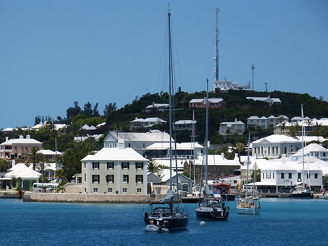
English: The former Royal Army Ordnance Corps depot of Ordnance Island (left), the former Commissariat Department depot (later a Royal Army Service Corps Wharf, and containing Bermuda's only brick building) in St. George's Town, in the Imperial fortress colony of Bermuda, and Fort George on the crest of Mount Hill, above the town. A modern wireless and radar station, utilised by Bermuda Harbour Radio and the Bermuda Maritime Operations Centre, has been erected on top of the keep of Fort George. The viewpoint is Convict Bay, historically used by the Royal Navy (which moored a convict hulk there), then as part of St. George's Garrison (part of the Bermuda Garrison), and as a Royal Canadian Navy base, HMCS Somers Isles, during the Second World War. |
| Date | |
| Source | Own work |
| Author | Seán Pòl Ó Creachmhaoil |
| Camera location | | View this and other nearby images on: OpenStreetMap |
|---|
Licensing
[edit]
I, the copyright holder of this work, hereby publish it under the following license:
This file is licensed under the Creative Commons Attribution-Share Alike 4.0 International license.
- You are free:
- to share – to copy, distribute and transmit the work
- to remix – to adapt the work
- Under the following conditions:
- attribution – You must give appropriate credit, provide a link to the license, and indicate if changes were made. You may do so in any reasonable manner, but not in any way that suggests the licensor endorses you or your use.
- share alike – If you remix, transform, or build upon the material, you must distribute your contributions under the same or compatible license as the original.
File history
Click on a date/time to view the file as it appeared at that time.
| Date/Time | Thumbnail | Dimensions | User | Comment | |
|---|---|---|---|---|---|
| current | 00:00, 24 August 2021 | | 4,608 × 3,456 (5.71 MB) | Aodhdubh (talk | contribs) | Uploaded own work with UploadWizard |
You cannot overwrite this file.
File usage on Commons
There are no pages that use this file.
File usage on other wikis
The following other wikis use this file:
- Usage on en.wikipedia.org
- Usage on pt.wikipedia.org
Metadata
Categories:
- St. George's, Bermuda
- Ordnance Island
- Imperial fortress
- Royal Army Ordnance Corps
- Royal Army Service Corps
- Royal Artillery
- Royal Engineers
- Forts in Bermuda
- Fortifications
- Coastal artillery in the United Kingdom
- Coastal artillery
- Signal towers
- Military history of the United Kingdom
- History of the British Army
- History of Bermuda
- Radio communications
- Radar stations in the United Kingdom