File:Operation Chrome Dome route.jpg
From Wikimedia Commons, the free media repository
Jump to navigation
Jump to search

Size of this preview: 800 × 501 pixels. Other resolutions: 320 × 200 pixels | 640 × 400 pixels | 1,024 × 641 pixels | 1,475 × 923 pixels.
Original file (1,475 × 923 pixels, file size: 421 KB, MIME type: image/jpeg)
File information
Structured data
Captions
Captions
Add a one-line explanation of what this file represents
Summary
[edit]
|
This military map image could be re-created using vector graphics as an SVG file. This has several advantages; see Commons:Media for cleanup for more information. If an SVG form of this image is available, please upload it and afterwards replace this template with
{{vector version available|new image name}}.
It is recommended to name the SVG file “Operation Chrome Dome route.svg”—then the template Vector version available (or Vva) does not need the new image name parameter. |
 | This military map image was uploaded in the JPEG format even though it consists of non-photographic data. This information could be stored more efficiently or accurately in the PNG or SVG format. If possible, please upload a PNG or SVG version of this image without compression artifacts, derived from a non-JPEG source (or with existing artifacts removed). After doing so, please tag the JPEG version with {{Superseded|NewImage.ext}} and remove this tag. This tag should not be applied to photographs or scans. If this image is a diagram or other image suitable for vectorisation, please tag this image with {{Convert to SVG}} instead of {{BadJPEG}}. If not suitable for vectorisation, use {{Convert to PNG}}. For more information, see {{BadJPEG}}. |
| DescriptionOperation Chrome Dome route.jpg |
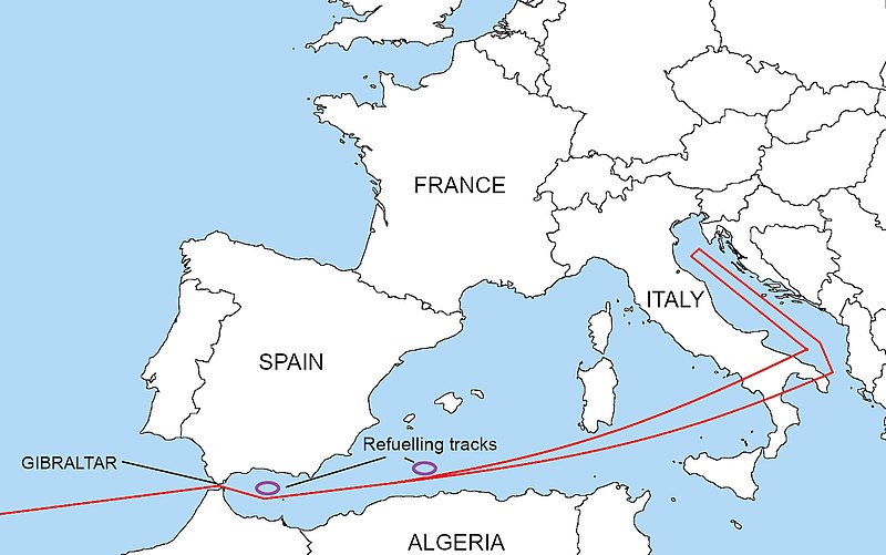
English: This aircraft navigational route is the Eastern section of a 15,000-mile, 26-hour, round-trip airborne alert from Miami (HAFB), threatening six targets in the Soviet Union. Note the two air-refueling tracks near Spain. At the 22-hour mark, west-bound, upon receipt of the "GO CODE", the B-52H remains capable of reversing direction and reaching at least the first target without additional refueling. Thereafter, assuming survival, the flight plan continues across N. Africa, Brazil, to recover the aircraft at Edwards AFB, California. |
| Date | 13 April 2006 (original upload date) |
| Source | Transferred from en.wikipedia to Commons by Zscout370 using CommonsHelper. |
| Author | The original uploader was Emt147 at English Wikipedia. |
Licensing
[edit]This file is licensed under the Creative Commons Attribution-Share Alike 2.5 Generic license.
- You are free:
- to share – to copy, distribute and transmit the work
- to remix – to adapt the work
- Under the following conditions:
- attribution – You must give appropriate credit, provide a link to the license, and indicate if changes were made. You may do so in any reasonable manner, but not in any way that suggests the licensor endorses you or your use.
- share alike – If you remix, transform, or build upon the material, you must distribute your contributions under the same or compatible license as the original.
Original upload log
[edit]The original description page was here. All following user names refer to en.wikipedia.
- 2006-04-13 03:50 Emt147 554×364× (61437 bytes) PD image based on maps from WP:Maps to replace copyrighted Google Earth version.
File history
Click on a date/time to view the file as it appeared at that time.
| Date/Time | Thumbnail | Dimensions | User | Comment | |
|---|---|---|---|---|---|
| current | 15:57, 4 April 2021 |  | 1,475 × 923 (421 KB) | Hohum (talk | contribs) | Clearer version |
| 23:31, 30 May 2018 |  | 554 × 364 (67 KB) | Hohum (talk | contribs) | Lighter | |
| 09:11, 17 January 2012 |  | 554 × 364 (62 KB) | EBB (talk | contribs) | made consistent with the political boundaries of the time | |
| 02:21, 11 May 2011 |  | 554 × 364 (60 KB) | File Upload Bot (Magnus Manske) (talk | contribs) | {{BotMoveToCommons|en.wikipedia|year={{subst:CURRENTYEAR}}|month={{subst:CURRENTMONTHNAME}}|day={{subst:CURRENTDAY}}}} {{Information |Description={{en|This aircraft navigational route is the Eastern section of a 15,000 mile, 26 hour, round-trip airborne |
You cannot overwrite this file.
File usage on Commons
The following page uses this file:
File usage on other wikis
The following other wikis use this file:
- Usage on de.wikipedia.org
- Usage on en.wikipedia.org
- Usage on fi.wikipedia.org
- Usage on fr.wikipedia.org
- Usage on ja.wikipedia.org
- Usage on ms.wikipedia.org
- Usage on no.wikipedia.org
- Usage on pt.wikipedia.org
- Usage on ru.wikipedia.org
- Usage on sl.wikipedia.org
Metadata
This file contains additional information such as Exif metadata which may have been added by the digital camera, scanner, or software program used to create or digitize it. If the file has been modified from its original state, some details such as the timestamp may not fully reflect those of the original file. The timestamp is only as accurate as the clock in the camera, and it may be completely wrong.
| Horizontal resolution | 28.35 dpc |
|---|---|
| Vertical resolution | 28.35 dpc |
| Software used | GIMP 2.10.20 |
| File change date and time | 16:57, 4 April 2021 |
| Color space | sRGB |
| Unique ID of original document | xmp.did:2e64c558-57a6-45b2-b43a-131fff276858 |
