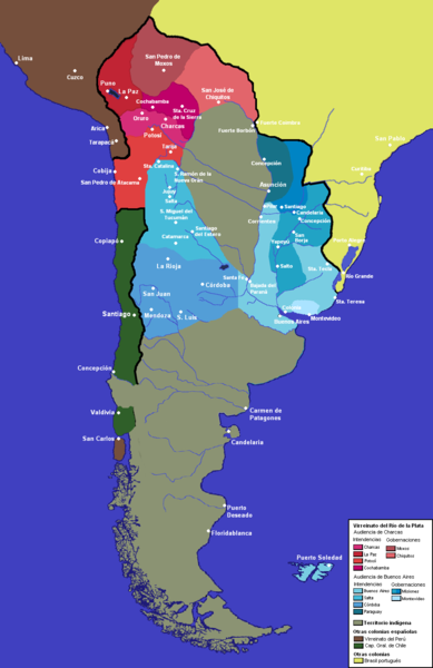
File:Nuevo mapa del virreinato del rio de la plata.PNG
From Wikimedia Commons, the free media repository
Jump to navigation
Jump to search

Size of this preview: 389 × 600 pixels. Other resolutions: 156 × 240 pixels | 311 × 480 pixels | 940 × 1,449 pixels.
Original file (940 × 1,449 pixels, file size: 310 KB, MIME type: image/png)
File information
Structured data
Captions
Captions
Add a one-line explanation of what this file represents
Summary
[edit]| DescriptionNuevo mapa del virreinato del rio de la plata.PNG | Mapa del Virreinato del Río de la Plata alrededor de 1783 |
| Date | |
| Source | Own work |
| Author | Franco-eisenhower |
Licensing
[edit]| Public domainPublic domainfalsefalse |
| I, the copyright holder of this work, release this work into the public domain. This applies worldwide. In some countries this may not be legally possible; if so: I grant anyone the right to use this work for any purpose, without any conditions, unless such conditions are required by law. |
derivative works
[edit]Derivative works of this file: VIRREINATOsur.png
File history
Click on a date/time to view the file as it appeared at that time.
| Date/Time | Thumbnail | Dimensions | User | Comment | |
|---|---|---|---|---|---|
| current | 09:40, 19 October 2014 |  | 940 × 1,449 (310 KB) | Keysanger (talk | contribs) | There was no such frontier during the Spanish colony |
| 17:48, 31 May 2012 |  | 940 × 1,449 (326 KB) | Franco-eisenhower (talk | contribs) | Varias correcciones, cambio de orientación. | |
| 05:05, 26 May 2012 |  | 775 × 1,403 (92 KB) | Franco-eisenhower (talk | contribs) | Agrego línea de frontera entre el Virreinato y Chile, en la región patagónica. Según Real Cédula de 1570 los límites en la Patagonia transcurrían a lo largo de la Cordillera de los Andes, incluso si la Patagonia era una región inconquistada. [h... | |
| 04:33, 20 May 2011 |  | 775 × 1,403 (90 KB) | Franco-eisenhower (talk | contribs) | fortines + nuevas ciudades + límites de la banda oriental | |
| 04:30, 20 May 2011 |  | 775 × 1,403 (90 KB) | Franco-eisenhower (talk | contribs) | fortines + nuevas ciudades + límites de la banda oriental | |
| 14:56, 14 May 2011 |  | 775 × 1,403 (89 KB) | Franco-eisenhower (talk | contribs) | Agregando gobernacion de Montevideo y de las Misiones. Otros cambios menores. | |
| 14:03, 12 May 2011 |  | 775 × 1,403 (88 KB) | Franco-eisenhower (talk | contribs) | ||
| 06:43, 23 April 2011 |  | 775 × 1,403 (86 KB) | Franco-eisenhower (talk | contribs) | ||
| 02:20, 5 October 2010 |  | 775 × 1,403 (98 KB) | Franco-eisenhower (talk | contribs) | Simplificación/armonización de los límites patagónicos. | |
| 08:46, 4 October 2010 |  | 775 × 1,403 (98 KB) | Franco-eisenhower (talk | contribs) | Mejoras en la calidad de la letra para facilitar la lectura. Cambios en la frontera de la Banda Oriental. Cambios en la frontera de la Intendencia entre Buenos Aires y la de Paraguay basados en el artículo "[[Disputa de Curupayty y Lomas de Pedro Gonzál |
You cannot overwrite this file.
File usage on Commons
The following page uses this file:
File usage on other wikis
The following other wikis use this file:
- Usage on ami.wikipedia.org
- Usage on ast.wikipedia.org
- Usage on azb.wikipedia.org
- Usage on bn.wikipedia.org
- Usage on ca.wikipedia.org
- Usage on cs.wikipedia.org
- Usage on en.wikipedia.org
- Usage on es.wikipedia.org
- Usage on fr.wikipedia.org
- Usage on he.wikipedia.org
- Usage on ja.wikipedia.org
- Usage on pt.wikipedia.org
- Usage on ru.wikipedia.org
- Usage on sk.wikipedia.org
- Usage on zh.wikipedia.org
Metadata
This file contains additional information such as Exif metadata which may have been added by the digital camera, scanner, or software program used to create or digitize it. If the file has been modified from its original state, some details such as the timestamp may not fully reflect those of the original file. The timestamp is only as accurate as the clock in the camera, and it may be completely wrong.
| Horizontal resolution | 28.35 dpc |
|---|---|
| Vertical resolution | 28.35 dpc |
| File change date and time | 09:38, 19 October 2014 |