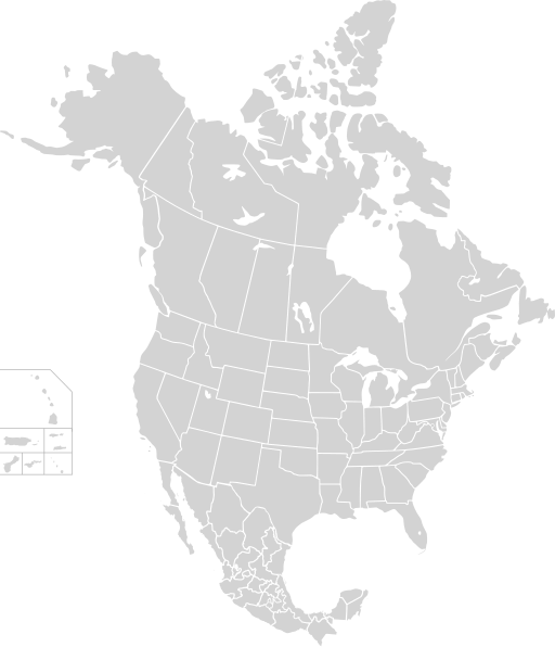
File:North America second level political division 2.svg

Original file (SVG file, nominally 512 × 596 pixels, file size: 132 KB)
Captions
Captions
Summary
[edit]| DescriptionNorth America second level political division 2.svg |
English: Map of North America and its second-level political divisions. Canadian provinces, US and Mexican states. Canada, Mexico, United States.
Non-contiguous parts of a states/provinces are "grouped" together with the main area of the state/provinces, so any state/provinces can be coloured in completion with one click anywhere on the state/provinces's area. Also, all states/provinces have a "id" attached to them, making them easy to find. Select "find" and then enter in the state/provinces's ISO 3166-2 code in the "id" field to find it. The codes can be found here (Canada), here (USA) and here (Mexico). |
| Date | |
| Source |
Canada and US map: BlankMap-USA-states-Canada-provinces, HI closer.svg by Lokal_Profil. |
| Author | Alex Covarrubias |
| Permission (Reusing this file) |
This file is licensed under the Creative Commons Attribution-Share Alike 2.5 Generic license.
|
| Other versions |
Derivative works of this file: |
File history
Click on a date/time to view the file as it appeared at that time.
| Date/Time | Thumbnail | Dimensions | User | Comment | |
|---|---|---|---|---|---|
| current | 01:51, 23 November 2020 |  | 512 × 596 (132 KB) | Ponderosapine210 (talk | contribs) | Added the prominent islands of Manitoulin (Ontario) and Isle Royale (Michigan) to the Great Lakes. |
| 23:07, 1 June 2019 |  | 512 × 596 (130 KB) | Fluffy89502 (talk | contribs) | added territories, made DC visible, adjusted mexican borders | |
| 12:23, 4 April 2014 |  | 1,712 × 1,992 (270 KB) | Lommes (talk | contribs) | made the borders between the mexican subdivisions the same size as their canadian / us counterparts. | |
| 23:23, 8 December 2007 |  | 1,712 × 1,992 (327 KB) | Lokal Profil (talk | contribs) | Code cleanup | |
| 07:55, 7 October 2007 |  | 1,712 × 1,992 (342 KB) | AlexCovarrubias (talk | contribs) | == Summary == {{Information |Description=Map of North America and its second-level political divisions. Canadian provinces, US and Mexican states. Canada, Mexico, United States. |Source=Canada and US map by Alan Rockefeller. Mexico map by Alex Covarrubias |
You cannot overwrite this file.
File usage on Commons
The following 48 pages use this file:
- File:Ancyloxypha numitor range map.PNG
- File:Anthocharis midea range map.JPG
- File:Asterocampa celtis range map.PNG
- File:Asterocampa clyton range map.PNG
- File:Battus philenor range map.JPG
- File:Boloria bellona range map.JPG
- File:CFL teams.svg
- File:Calephelis mutica range map.PNG
- File:Callophrys henrici range map.PNG
- File:Cercyonis pegala range map.JPG
- File:Colias philodice range map.JPG
- File:Cryptobranchus alleganiensis bishopi range map.png
- File:Eumaeus atala range map.JPG
- File:Eurytides marcellus range map.PNG
- File:Hypaurotis crysalus range map.JPG
- File:Kalakaua's 1874-75 state visit map.svg
- File:Limenitis arthemis range map.PNG
- File:Lycaena epixanthe range map.PNG
- File:Lycaena hermes range map.JPG
- File:NAHL teams and conferences map - 2014-15.svg
- File:NAHL teams and conferences map - 2015-16.svg
- File:North America Range Argia nahuana.svg
- File:North America Range Argia plana.svg
- File:North America Range Epitheca cynosura.svg
- File:North America Range Hetaerina americana.svg
- File:North America Range Libellula forensis.svg
- File:North America Range Perithemis tenera.svg
- File:North america blank range map.png
- File:Panulirus interruptus distribution.png
- File:Papilio brevicauda range map.PNG
- File:Papilio eurymedon range map.JPG
- File:Papilio glaucus range map.JPG
- File:Papilio palamedes range map.PNG
- File:Papilio rutulus range map.PNG
- File:Papilio troilus range map.PNG
- File:Parides alopius range map.JPG
- File:Peromyscus eremicus distribution.svg
- File:Pieris virginiensis range map.JPG
- File:Polites themistocles range map.PNG
- File:Pontia protodice range map.JPG
- File:Satyrium calanus range map.PNG
- File:Satyrium titus range map.JPG
- File:Sauromalus ater distribution.svg
- File:Sorex cinereus distribution.svg
- File:Sorex palustris distribution.svg
- File:Thorybes bathyllus range map.PNG
- File:TramCCFLmapa(NAmerica).svg
- File:Verkaufsalter für Tabakwaren in Nordamerika.svg
File usage on other wikis
The following other wikis use this file:
- Usage on en.wikipedia.org
- Usage on sk.wikipedia.org
Metadata
This file contains additional information such as Exif metadata which may have been added by the digital camera, scanner, or software program used to create or digitize it. If the file has been modified from its original state, some details such as the timestamp may not fully reflect those of the original file. The timestamp is only as accurate as the clock in the camera, and it may be completely wrong.
| Width | 100% |
|---|---|
| Height | 100% |