File:Niederrhein-region-map.png
Jump to navigation
Jump to search
Size of this preview: 399 × 599 pixels. Other resolutions: 160 × 240 pixels | 609 × 914 pixels.
Original file (609 × 914 pixels, file size: 272 KB, MIME type: image/png)
Captions
Captions
Add a one-line explanation of what this file represents
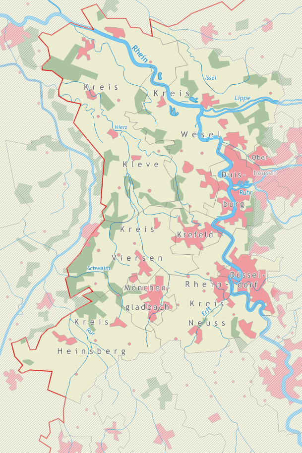
Map of the german region Niederrhein
- The map shows the german region de:Niederrhein
- "drawn" by myself, Daniel Ullrich (Threedots) with CorelDRAW 12 in March 2005
- If you ask for, I will give you the .cdr- / .xfc-file or I'll correct it or create another language version
Karte der Region Niederrhein
- Die Karte zeigt die Region Niederrhein
- von mir selbst, Daniel Ullrich (Threedots) im März 2005 mit CorelDRAW 12 "gezeichnet"
- Auf Anfrage stelle ich gern die .cdr- / .xfc-Datei bereit oder erstelle selbst korrigierte oder andersprachige Versionen

|
Permission is granted to copy, distribute and/or modify this document under the terms of the GNU Free Documentation License, Version 1.2 or any later version published by the Free Software Foundation; with no Invariant Sections, no Front-Cover Texts, and no Back-Cover Texts. A copy of the license is included in the section entitled GNU Free Documentation License. |
I, the copyright holder of this work, hereby publish it under the following licenses:
|
|
Permission is granted to copy, distribute and/or modify this document under the terms of the GNU Free Documentation License, Version 1.2 or any later version published by the Free Software Foundation; with no Invariant Sections, no Front-Cover Texts, and no Back-Cover Texts. A copy of the license is included in the section entitled GNU Free Documentation License. |
| This file is licensed under the Creative Commons Attribution-Share Alike 3.0 Unported license. | ||
| ||
| This licensing tag was added to this file as part of the GFDL licensing update. |
This file is licensed under the Creative Commons Attribution-Share Alike 2.0 Germany license.
- You are free:
- to share – to copy, distribute and transmit the work
- to remix – to adapt the work
- Under the following conditions:
- attribution – You must give appropriate credit, provide a link to the license, and indicate if changes were made. You may do so in any reasonable manner, but not in any way that suggests the licensor endorses you or your use.
- share alike – If you remix, transform, or build upon the material, you must distribute your contributions under the same or compatible license as the original.

You may select the license of your choice.
File history
Click on a date/time to view the file as it appeared at that time.
| Date/Time | Thumbnail | Dimensions | User | Comment | |
|---|---|---|---|---|---|
| current | 15:11, 3 March 2006 | | 609 × 914 (272 KB) | Threedots (talk | contribs) | corrected rivers name "Schwelm" to "Schwalm" |
| 01:53, 16 March 2005 |  | 609 × 914 (107 KB) | Threedots (talk | contribs) | Map of the german region de:Niederrhein {{GFDL}} |
You cannot overwrite this file.
File usage on Commons
The following page uses this file:
File usage on other wikis
The following other wikis use this file:
- Usage on de.wikipedia.org
- Usage on de.wikivoyage.org
- Usage on en.wikipedia.org
- Usage on eo.wikipedia.org
- Usage on fy.wikipedia.org
- Usage on ia.wikipedia.org
- Usage on ksh.wikipedia.org
- Usage on nl.wikipedia.org
- Usage on ru.wikipedia.org
- Usage on sv.wikipedia.org