File:Newport News 1800 map imageCA8Q5H1A.jpg

Original file (3,684 × 4,095 pixels, file size: 1.84 MB, MIME type: image/jpeg)
Captions
Captions
Summary
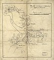
[edit]| DescriptionNewport News 1800 map imageCA8Q5H1A.jpg | Plan des environs de Williamsburg, York, Hampton, et Portsmouth |
| Date | |
| Source | Library of Congress, Rochambeau Map Collection |
| Author | Unknown authorUnknown author |
Licensing
[edit]| Public domainPublic domainfalsefalse |
|
This work is in the public domain in its country of origin and other countries and areas where the copyright term is the author's life plus 100 years or fewer. | |
| This file has been identified as being free of known restrictions under copyright law, including all related and neighboring rights. | |
https://creativecommons.org/publicdomain/mark/1.0/PDMCreative Commons Public Domain Mark 1.0falsefalse

|
This map is available from the United States Library of Congress's Geography & Map Division
under the digital ID g3882h.ar144500. This tag does not indicate the copyright status of the attached work. A normal copyright tag is still required. See Commons:Licensing. العربية ∙ беларуская (тарашкевіца) ∙ বাংলা ∙ čeština ∙ Deutsch ∙ English ∙ español ∙ فارسی ∙ suomi ∙ français ∙ galego ∙ עברית ∙ magyar ∙ Bahasa Indonesia ∙ italiano ∙ 日本語 ∙ Bahaso Melayu Jambi ∙ lietuvių ∙ македонски ∙ മലയാളം ∙ Nederlands ∙ polski ∙ português ∙ português do Brasil ∙ română ∙ русский ∙ sicilianu ∙ slovenčina ∙ slovenščina ∙ Türkçe ∙ українська ∙ 中文 ∙ 中文(简体) ∙ 中文(繁體) ∙ +/− |
File history
Click on a date/time to view the file as it appeared at that time.
| Date/Time | Thumbnail | Dimensions | User | Comment | |
|---|---|---|---|---|---|
| current | 12:37, 7 April 2011 |  | 3,684 × 4,095 (1.84 MB) | Lumu (talk | contribs) | full resolution |
| 15:36, 25 March 2009 |  | 450 × 500 (47 KB) | Cropbot (talk | contribs) | upload cropped version, operated by User:SCEhardt. Summary: crop | |
| 00:53, 29 November 2008 |  | 496 × 542 (53 KB) | Pohick2 (talk | contribs) | == Summary == {{Information |Description= Plan des environs de Williamsburg, York, Hampton, et Portsmouth |Source=Library of Congress, Rochambeau Map Collection |Date=1781 |Author= unknown |Permission= |other_versions= }} == [[Commons:Copyright tags|Lice |
You cannot overwrite this file.
File usage on Commons
There are no pages that use this file.
File usage on other wikis
The following other wikis use this file:
- Usage on en.wikipedia.org
Metadata
This file contains additional information such as Exif metadata which may have been added by the digital camera, scanner, or software program used to create or digitize it. If the file has been modified from its original state, some details such as the timestamp may not fully reflect those of the original file. The timestamp is only as accurate as the clock in the camera, and it may be completely wrong.
| Orientation | Normal |
|---|---|
| Horizontal resolution | 72 dpi |
| Vertical resolution | 72 dpi |
| Software used | Adobe Photoshop CS4 Windows |
| File change date and time | 14:36, 7 April 2011 |
| Color space | sRGB |