File:Newbritain lrg.jpg
Jump to navigation
Jump to search

Size of this preview: 800 × 486 pixels. Other resolutions: 320 × 194 pixels | 640 × 389 pixels | 1,024 × 622 pixels | 1,280 × 777 pixels | 2,964 × 1,800 pixels.
Original file (2,964 × 1,800 pixels, file size: 1.31 MB, MIME type: image/jpeg)
Captions
Captions
Add a one-line explanation of what this file represents
| Description |
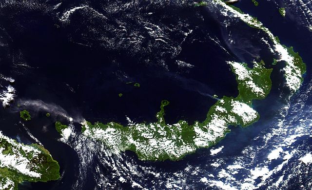
English: Three volcanoes in Papua New Guinea’s West New Britain province spewed ash on June 21, 2005. The Moderate Resolution Imaging Spectroradiometer (MODIS), flying on NASA’s Aqua satellite captured this image of Langila, Ulawun, and Rabaul the same day. At the time MODIS captured this image, Langila showed the biggest plume of volcanic ash, followed by Ulawun. Both volcanoes are enlarged below the main image. In all cases, winds pushed the ash clouds to the northwest, over the ocean. |
| Date | |
| Source | http://visibleearth.nasa.gov/view_rec.php?id=20049 |
| Author | NASA image courtesy Jesse Allen, based on data from the MODIS Rapid Response Team at NASA GSFC |
|
| This file is in the public domain in the United States because it was solely created by NASA. NASA copyright policy states that "NASA material is not protected by copyright unless noted". (See Template:PD-USGov, NASA copyright policy page or JPL Image Use Policy.) | ||
 |
Warnings:
|
File history
Click on a date/time to view the file as it appeared at that time.
| Date/Time | Thumbnail | Dimensions | User | Comment | |
|---|---|---|---|---|---|
| current | 10:56, 22 January 2007 | | 2,964 × 1,800 (1.31 MB) | Darwinek (talk | contribs) | |
| 11:33, 4 December 2005 |  | 1,500 × 911 (504 KB) | Vzb83~commonswiki (talk | contribs) | The island on New Britain, Papua New Guinea in June 2005. Clearly visible is ash plume from Langila and Ulawun volcanoes. Category:Papua New Guinea |
You cannot overwrite this file.
File usage on Commons
The following 3 pages use this file:
File usage on other wikis
The following other wikis use this file:
- Usage on af.wikipedia.org
- Usage on ar.wikipedia.org
- Usage on arz.wikipedia.org
- Usage on ast.wikipedia.org
- Usage on az.wikipedia.org
- Usage on ba.wikipedia.org
- Usage on br.wikipedia.org
- Usage on bs.wikipedia.org
- Usage on ca.wikipedia.org
- Usage on ceb.wikipedia.org
- Usage on cs.wikipedia.org
- Usage on cs.wikinews.org
- Usage on cy.wikipedia.org
- Usage on de.wikipedia.org
- Usage on diq.wikipedia.org
- Usage on el.wikipedia.org
- Usage on en.wikipedia.org
- Usage on eo.wikipedia.org
- Usage on es.wikipedia.org
- Usage on eu.wikipedia.org
- Usage on fa.wikipedia.org
- Usage on fi.wikipedia.org
- Usage on fr.wikipedia.org
- Usage on gd.wikipedia.org
- Usage on gl.wikipedia.org
- Usage on he.wikipedia.org
- Usage on hu.wikipedia.org
- Usage on hy.wikipedia.org
- Usage on id.wikipedia.org
- Usage on incubator.wikimedia.org
- Usage on it.wikipedia.org
View more global usage of this file.
Metadata
Categories:
- Photos of Papua New Guinea by the Aqua (satellite) MODIS
- Photos of volcanic eruptions by the Aqua (satellite) MODIS
- New Britain
- 2005 eruptions in Papua New Guinea
- Volcanic eruptions of the Rabaul Caldera
- Langila volcano
- Ulawun
- Simultaneous volcanic eruptions
- Rabaul caldera in 2005
- Satellite pictures of volcanic eruptions in Papua New Guinea
- Satellite pictures of volcanoes in Papua New Guinea in 2005
- Satellite pictures of New Britain