File:Nebraska 1718.jpg
Nebraska_1718.jpg (634 × 497 pixels, file size: 147 KB, MIME type: image/jpeg)
Captions
Captions
| DescriptionNebraska 1718.jpg |
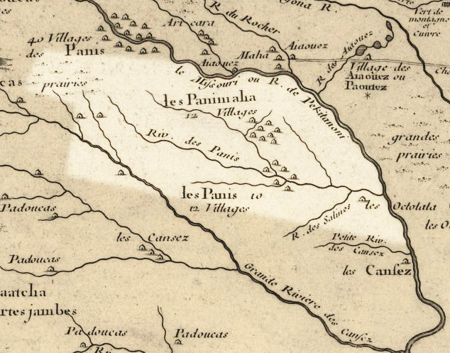
English: Nebraska 1718, approximate modern state area highlighted, from Carte de la Louisiane et du cours du Mississipi by Guillaume de L'Isle. Borders are very rough, since the Republican and Platte Rivers are shown with unusual routes. LicensingMy contributions cleaning and highlighting are also donated to Public Domain. Bill Whittaker (talk) 20:14, 27 July 2009 (UTC) The Library of Congress scan is covered by: The 1718 map is covered by: |
|||||||||||||||||||||||
| Date | (mod. 2009) | |||||||||||||||||||||||
| Source | Library of Congress Public Domain Site: http://hdl.loc.gov/loc.gmd/g3700.ct000666 | |||||||||||||||||||||||
| Author |
creator QS:P170,Q1389662 |
|||||||||||||||||||||||
| Permission (Reusing this file) |
US Govt Public Domain, also author +100 years | |||||||||||||||||||||||
Licensing
[edit]| Public domainPublic domainfalsefalse |
|
This work is in the public domain in its country of origin and other countries and areas where the copyright term is the author's life plus 100 years or fewer. | |
| This file has been identified as being free of known restrictions under copyright law, including all related and neighboring rights. | |
https://creativecommons.org/publicdomain/mark/1.0/PDMCreative Commons Public Domain Mark 1.0falsefalse
Original upload log
[edit]- 2009-08-03 18:28 Billwhittaker 634×497× (150651 bytes) {{Information |Description = [[Nebraska]] 1718, approximate modern state area highlighted, from ''Carte de la Louisiane et du cours du Mississipi'' by [[Guillaume de L'Isle]]. Borders are very rough, since the Republican and Platte Rivers are shown wi
File history
Click on a date/time to view the file as it appeared at that time.
| Date/Time | Thumbnail | Dimensions | User | Comment | |
|---|---|---|---|---|---|
| current | 19:49, 21 September 2009 |  | 634 × 497 (147 KB) | Jeangagnon (talk | contribs) | {{Information |Description={{en|en:Nebraska 1718, approximate modern state area highlighted, from ''Carte de la Louisiane et du cours du Mississipi'' by en:Guillaume de L'Isle. Borders are very rough, since the Republican and Platte Rivers are |
You cannot overwrite this file.
File usage on Commons
There are no pages that use this file.
File usage on other wikis
The following other wikis use this file:
- Usage on az.wikipedia.org
- Usage on en.wikipedia.org
- Usage on es.wikipedia.org
- Usage on fr.wikipedia.org
- Usage on gu.wikipedia.org
- Usage on ja.wikipedia.org
- Usage on kn.wikipedia.org
- Usage on ko.wikipedia.org
- Usage on pt.wikipedia.org
- Usage on ru.wikipedia.org
- Usage on uk.wikipedia.org
Metadata
This file contains additional information such as Exif metadata which may have been added by the digital camera, scanner, or software program used to create or digitize it. If the file has been modified from its original state, some details such as the timestamp may not fully reflect those of the original file. The timestamp is only as accurate as the clock in the camera, and it may be completely wrong.
| Orientation | Normal |
|---|---|
| Horizontal resolution | 72 dpi |
| Vertical resolution | 72 dpi |
| Software used | Adobe Photoshop CS3 Windows |
| File change date and time | 13:25, 3 August 2009 |
| Color space | Uncalibrated |

