File:Nairobi, Kenya ESA418210.jpg

Original file (5,712 × 5,340 pixels, file size: 6.86 MB, MIME type: image/jpeg)
Captions
Captions
Summary
[edit]| DescriptionNairobi, Kenya ESA418210.jpg |
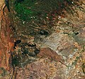
English: The Copernicus Sentinel-2 mission takes us over Nairobi, one of the fastest growing cities in East Africa.
The population of Nairobi has increased significantly in the last 30 years, with rural residents flocking to the city in search of employment. The city, visible in the centre of the image, now has a population of over three million, with the vast majority spread over 200 informal settlements. Kibera, which can be seen as a light-coloured patch at the south-western edge of the city, is considered one of the largest urban slums in Nairobi. Most residents live in small mud shacks with poor sanitation, a lack of electricity and limited access to clean water. While migration provides economic benefits to the city, it also creates environmental challenges. Owing to its urbanisation, the city has spread into green spaces such as the nearby parks and forests. In this image, the densely populated area is contrasted with the flat plains of Nairobi National Park, directly south of the city. The 117 sq km of wide-open grass plains is coloured in light-brown. The park is home to lions, leopards, cheetahs and has a black rhino sanctuary. The dark patches in the image are forests. The Ngong Forest, to the west of the city, includes exotic and indigenous trees, and hosts a variety of wild animals including wild pigs, porcupines, and dik-diks. To the north of the city, the dark Karura Forest is visible. The 1000 hectare urban forest features a 15-m waterfall, and hosts a variety of animals including bush pigs, bushbucks, suni and harvey’s duiker, as well as some 200 bird species. Although Africa is responsible for less than 5% of global greenhouse-gas emissions, the majority of the continent is directly impacted by climate change. Rapid population growth and urbanisation also exposes residents to climate risks. On 14 March 2019, the first regional edition of theOne Planet Summittook place at the UN Compound, which is in the north of the city. The One Planet Summit, part of theUN Environment Assembly, focuses on protecting biodiversity, promoting renewable energies and fostering resilience and adaptation to climate change. Data from Copernicus Sentinel-2 can help monitor changes in urban expansion and land-cover change. Copernicus Sentinel-2 is a two-satellite mission. Each satellite carries a high-resolution camera that images Earth’s surface in 13 spectral bands. This image, which was captured on 3 February 2019, is also featured on theEarth from Space video programme. As delegates gather in Nairobi for the UN Environment Assembly, ESA is saddened by the news of the Ethiopian Airlines accident. Lives lost included those working for organisations also dedicated to achieving a better world for all and who were travelling to the assembly. Our thoughts are with the families, colleagues and friends of those affected. |
| Date | |
| Source | http://www.esa.int/spaceinimages/Images/2019/03/Nairobi_Kenya |
| Author | European Space Agency |
| Permission (Reusing this file) |
contains modified Copernicus Sentinel data (2019), processed by ESA,CC BY-SA 3.0 IGO |
| Title InfoField | Nairobi, Kenya |
| System InfoField | Copernicus |
| Set InfoField | Earth observation image of the week |
| Mission InfoField | Sentinel-2 |
| Activity InfoField | Observing the Earth |
Licensing
[edit]- You are free:
- to share – to copy, distribute and transmit the work
- to remix – to adapt the work
- Under the following conditions:
- attribution – You must give appropriate credit, provide a link to the license, and indicate if changes were made. You may do so in any reasonable manner, but not in any way that suggests the licensor endorses you or your use.
- share alike – If you remix, transform, or build upon the material, you must distribute your contributions under the same or compatible license as the original.


|
This image contains data from a satellite in the Copernicus Programme, such as Sentinel-1, Sentinel-2 or Sentinel-3. Attribution is required when using this image.
Attribution: Contains modified Copernicus Sentinel data {{{year}}}
Attribution
The use of Copernicus Sentinel Data is regulated under EU law (Commission Delegated Regulation (EU) No 1159/2013 and Regulation (EU) No 377/2014). Relevant excerpts:
Free access shall be given to GMES dedicated data [...] made available through GMES dissemination platforms [...].
Access to GMES dedicated data [...] shall be given for the purpose of the following use in so far as it is lawful:
GMES dedicated data [...] may be used worldwide without limitations in time.
GMES dedicated data and GMES service information are provided to users without any express or implied warranty, including as regards quality and suitability for any purpose. |
Attribution
File history
Click on a date/time to view the file as it appeared at that time.
| Date/Time | Thumbnail | Dimensions | User | Comment | |
|---|---|---|---|---|---|
| current | 15:50, 29 July 2023 |  | 5,712 × 5,340 (6.86 MB) | Don-vip (talk | contribs) | hires |
| 12:27, 3 April 2019 |  | 2,856 × 2,670 (2.22 MB) | Fæ (talk | contribs) | European Space Agency, Id 418210, http://www.esa.int/spaceinimages/Images/2019/03/Nairobi_Kenya, User:Fæ/Project_list/ESA |
You cannot overwrite this file.
File usage on Commons
The following 2 pages use this file:
File usage on other wikis
The following other wikis use this file:
- Usage on ja.wikipedia.org