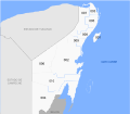
File:Municipios de Quintana Roo.svg
From Wikimedia Commons, the free media repository
Jump to navigation
Jump to search

Size of this PNG preview of this SVG file: 600 × 600 pixels. Other resolutions: 240 × 240 pixels | 480 × 480 pixels | 768 × 768 pixels | 1,024 × 1,024 pixels | 2,048 × 2,048 pixels | 1,300 × 1,300 pixels.
Original file (SVG file, nominally 1,300 × 1,300 pixels, file size: 69 KB)
File information
Structured data
Captions
Captions
Add a one-line explanation of what this file represents
| DescriptionMunicipios de Quintana Roo.svg |
Español: Mapa de los municipios del estado mexicano de Quintana Roo.
|
|||
| Date | Updated through 2020 | |||
| Source |
self-made This W3C-unspecified vector image was created with Inkscape . |
|||
| Author | Battroid | |||
| Permission (Reusing this file) |
|
|||
| Other versions |
|
File history
Click on a date/time to view the file as it appeared at that time.
| Date/Time | Thumbnail | Dimensions | User | Comment | |
|---|---|---|---|---|---|
| current | 12:20, 23 August 2022 |  | 1,300 × 1,300 (69 KB) | MikSed (talk | contribs) | update 2020 |
| 18:38, 5 June 2021 |  | 1,184 × 1,030 (116 KB) | Capmo (talk | contribs) | removed leading zeros | |
| 00:26, 21 December 2015 |  | 1,184 × 1,030 (140 KB) | Jaontiveros (talk | contribs) | Actualizando undécimo municipio Puerto Morelos | |
| 07:02, 16 February 2013 |  | 1,184 × 1,030 (139 KB) | MikSed (talk | contribs) | + Bacalar | |
| 06:45, 16 February 2013 |  | 1,184 × 1,062 (174 KB) | MikSed (talk | contribs) | + Municipio Bacalar | |
| 06:40, 1 February 2009 |  | 1,184 × 1,062 (175 KB) | Battroid (talk | contribs) | {{Information |Description=Mapa de los municipios del estado mexicano de Quintana Roo. |Source=self-made {{Inkscape}} |Date=May 4, 2008 |Author= Battroid |Permission={{PD-self}} |other_versions=<gallery>Image:Municipios-de-Quintana-Roo.j | |
| 06:23, 20 May 2008 |  | 1,184 × 1,062 (98 KB) | Battroid (talk | contribs) | {{Information |Description=Mapa de los municipios del estado mexicano de Quintana Roo. |Source=self-made {{Inkscape}} |Date=May 20, 2008 |Author= Battroid |Permission={{PD-self}} |other_versions=<gallery>Image:Municipios-de-Quintana-Roo. | |
| 21:10, 4 May 2008 |  | 1,184 × 1,062 (97 KB) | Battroid (talk | contribs) | {{Information |Description=Mapa de los municipios del estado mexicano de Quintana Roo. |Source=self-made {{Inkscape}} |Date=May 4, 2008 |Author= Battroid |Permission={{PD-self}} |other_versions=<gallery>Image:Municipios-de-Quintana-Roo.j |
You cannot overwrite this file.
File usage on Commons
The following 13 pages use this file:
- File:Bacalar en Quintana Roo.svg
- File:Benito Juarez en Quintana Roo.svg
- File:Cozumel en Quintana Roo.svg
- File:Felipe Carrillo Puerto en Quintana Roo.svg
- File:Isla Mujeres en Quintana Roo.svg
- File:Jose Maria Morelos en Quintana Roo.svg
- File:Lazaro Cardenas en Quintana Roo.svg
- File:Municipios-de-Quintana-Roo.jpg
- File:Municipios de Quintana Roo2.svg (file redirect)
- File:Othon P. Blanco en Quintana Roo.svg
- File:Puerto Morelos en Quintana Roo.svg
- File:Solidaridad en Quintana Roo.svg
- File:Tulum en Quintana Roo.svg
File usage on other wikis
The following other wikis use this file:
- Usage on an.wikipedia.org
- Usage on ca.wikipedia.org
- Usage on de.wikipedia.org
- Usage on en.wikipedia.org
- Usage on eo.wikipedia.org
- Usage on es.wikipedia.org
- Usage on fr.wikipedia.org
- Usage on it.wikipedia.org
- Usage on nl.wikipedia.org
- Usage on no.wikipedia.org
- Usage on pl.wikipedia.org
- Usage on qu.wikipedia.org
- Usage on ru.wikipedia.org
- Usage on sco.wikipedia.org
- Usage on zh.wikipedia.org
Metadata
This file contains additional information such as Exif metadata which may have been added by the digital camera, scanner, or software program used to create or digitize it. If the file has been modified from its original state, some details such as the timestamp may not fully reflect those of the original file. The timestamp is only as accurate as the clock in the camera, and it may be completely wrong.
| Width | 1300 |
|---|---|
| Height | 1300 |
