File:Mt Vesuvius 79 AD eruption-nl.svg

Original file (SVG file, nominally 646 × 391 pixels, file size: 87 KB)
Captions
Captions
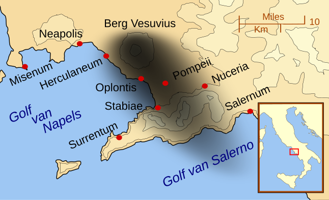
| DescriptionMt Vesuvius 79 AD eruption-nl.svg | A map showing the cities and towns affected by the eruption of Mount Vesuvius in 79 AD. The general shape of the ash and cinder fall (see w:en:pyroclast) is shown by the dark area to the southeast of Mt Vesuvius. (P.S. It seems strange to show the modern day English names for the two bodies of water - I am open to suggestions). This map shows lines and uses the Mercator projection (although that is not important on a map of this scale). North is, as usual, at the top of the map. |
| Date | (UTC) |
| Source | |
| Author |
MapMaster |
| Other versions |
[edit]
|
| This is a retouched picture, which means that it has been digitally altered from its original version. Modifications: Dutch version. The original can be viewed here: Mt Vesuvius 79 AD eruption 3.svg:
|
| This SVG file contains embedded text that can be translated into your language, using any capable SVG editor, text editor or the SVG Translate tool. For more information see: About translating SVG files. |
- You are free:
- to share – to copy, distribute and transmit the work
- to remix – to adapt the work
- Under the following conditions:
- attribution – You must give appropriate credit, provide a link to the license, and indicate if changes were made. You may do so in any reasonable manner, but not in any way that suggests the licensor endorses you or your use.
- share alike – If you remix, transform, or build upon the material, you must distribute your contributions under the same or compatible license as the original.

|
Permission is granted to copy, distribute and/or modify this document under the terms of the GNU Free Documentation License, Version 1.2 or any later version published by the Free Software Foundation; with no Invariant Sections, no Front-Cover Texts, and no Back-Cover Texts. A copy of the license is included in the section entitled GNU Free Documentation License.http://www.gnu.org/copyleft/fdl.htmlGFDLGNU Free Documentation Licensetruetrue |
Original upload log
[edit]This image is a derivative work of the following images:
- File:Mt_Vesuvius_79_AD_eruption_3.svg licensed with Cc-by-sa-3.0,2.5,2.0,1.0, GFDL
- 2007-10-16T01:07:31Z MapMaster 652x396 (115802 Bytes) corrected mis-named Gulf of Salerno
- 2007-10-15T04:02:09Z MapMaster 652x396 (114567 Bytes) Dropped Title sqaure, and added towns and names of the 2 bays.
- 2007-10-14T05:16:19Z MapMaster 652x454 (129125 Bytes) Minor changes made after seeing how it's rendered by Wikimedia
- 2007-10-14T05:11:08Z MapMaster 355x247 (128363 Bytes) {{Information |Description=A map showing the cities and town affected by the eruption of Mount Vesuvius in 79 AD. The general shape of the ash and cinder fall is shown by the dark area to the southeast of Mt Vesuvious. |Sour
Uploaded with derivativeFX
File history
Click on a date/time to view the file as it appeared at that time.
| Date/Time | Thumbnail | Dimensions | User | Comment | |
|---|---|---|---|---|---|
| current | 17:25, 2 December 2014 |  | 646 × 391 (87 KB) | Ras67 (talk | contribs) | frame removed |
| 13:13, 12 October 2010 |  | 652 × 396 (87 KB) | Citypeek (talk | contribs) | plain svg instead of inkscape svg. | |
| 18:19, 4 October 2010 |  | 652 × 396 (114 KB) | Citypeek (talk | contribs) | erased link in svg-file | |
| 18:02, 4 October 2010 |  | 652 × 396 (114 KB) | Citypeek (talk | contribs) | corrected errors | |
| 09:15, 4 October 2010 |  | 652 × 396 (114 KB) | Citypeek (talk | contribs) | {{Information |Description=A map showing the cities and towns affected by the eruption of Mount Vesuvius in 79 AD. The general shape of the ash and cinder fall (see w:en:pyroclast) is shown by the dark area to the southeast of Mt Vesuvius. (P.S. I |
You cannot overwrite this file.
File usage on Commons
The following 23 pages use this file:
- User talk:MapMaster
- File:Mt Vesuvius 79 AD eruption-fr.svg
- File:Mt Vesuvius 79 AD eruption-he.svg
- File:Mt Vesuvius 79 AD eruption-la.svg
- File:Mt Vesuvius 79 AD eruption-mk.svg
- File:Mt Vesuvius 79 AD eruption-nl.svg
- File:Mt Vesuvius 79 AD eruption-ru.svg
- File:Mt Vesuvius 79 AD eruption.svg
- File:Mt Vesuvius 79 AD eruption 3 nl.svg (file redirect)
- User talk:MapMaster
- File:Mt Vesuvius 79 AD eruption.svg
- File:Mt Vesuvius 79 AD eruption-la.svg
- File:Mt Vesuvius 79 AD eruption-he.svg
- File:Mt Vesuvius 79 AD eruption-nl.svg
- File:Mt Vesuvius 79 AD eruption-fr.svg
- File:Vesuvius 79 AD eruption Latina-pt.svg
- File:Mt Vesuvius 79 AD eruption-ru.svg
- Template:Other versions/Mt Vesuvius 79 AD eruption
- File:Mt Vesuvius 79 AD eruption ZH.svg
- File:Mt Vesuvius 79 AD eruption-mk.svg
- File:Mt Vesuvius 79 AD eruption ZH.svg
- File:Vesuvius 79 AD eruption Latina-pt.svg
- Template:Other versions/Mt Vesuvius 79 AD eruption
File usage on other wikis
The following other wikis use this file:
- Usage on en.wikipedia.org
- Usage on nl.wikipedia.org
Metadata
This file contains additional information such as Exif metadata which may have been added by the digital camera, scanner, or software program used to create or digitize it. If the file has been modified from its original state, some details such as the timestamp may not fully reflect those of the original file. The timestamp is only as accurate as the clock in the camera, and it may be completely wrong.
| Width | 645.59998 |
|---|---|
| Height | 390.79999 |


