File:Mono Lake Sunrise (5608523267).jpg

Original file (1,920 × 1,091 pixels, file size: 726 KB, MIME type: image/jpeg)
Captions
Captions
Summary
[edit]| DescriptionMono Lake Sunrise (5608523267).jpg |
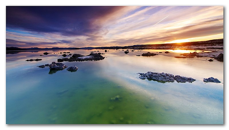
"It lies in a lifeless, treeless, hideous desert," Mark Twain wrote in his 1872 travelogue, Roughing It. "This solemn, silent, sailless sea--this lonely tenant of the loneliest spot on earth--is little graced with the picturesque." Once water enters this lake, which is actually a volcanic basin, there is no way out other than evaporation. According to scientists, for at least 760,000 years Mono Lake has been helping to develop recently discovered new form of life that lives in arsenic. It was a freezing cold morning but the sunrise was majestic. An awesome snowboarding runs were to follow the day :) . . LARGE (1920 x 1091) - ice in the water surface please.
| Facebook| Web | . |
| Date | |
| Source | Mono Lake Sunrise |
| Author | Dhilung Kirat from Santa Barbara, CA |
Licensing
[edit]- You are free:
- to share – to copy, distribute and transmit the work
- to remix – to adapt the work
- Under the following conditions:
- attribution – You must give appropriate credit, provide a link to the license, and indicate if changes were made. You may do so in any reasonable manner, but not in any way that suggests the licensor endorses you or your use.
| This image, originally posted to Flickr, was reviewed on 28 January 2013 by the administrator or reviewer File Upload Bot (Magnus Manske), who confirmed that it was available on Flickr under the stated license on that date. |
File history
Click on a date/time to view the file as it appeared at that time.
| Date/Time | Thumbnail | Dimensions | User | Comment | |
|---|---|---|---|---|---|
| current | 23:55, 28 January 2013 |  | 1,920 × 1,091 (726 KB) | File Upload Bot (Magnus Manske) (talk | contribs) | Transferred from Flickr by User:russavia |
You cannot overwrite this file.
File usage on Commons
The following page uses this file:
Metadata
This file contains additional information such as Exif metadata which may have been added by the digital camera, scanner, or software program used to create or digitize it. If the file has been modified from its original state, some details such as the timestamp may not fully reflect those of the original file. The timestamp is only as accurate as the clock in the camera, and it may be completely wrong.
| Camera manufacturer | Canon |
|---|---|
| Camera model | Canon EOS 40D |
| Copyright holder | matrixplay@gmail.com |
| Exposure time | 1/40 sec (0.025) |
| F-number | f/5 |
| ISO speed rating | 200 |
| Date and time of data generation | 20:48, 13 February 2011 |
| Lens focal length | 11 mm |
| Latitude | 37° 58′ 39.82″ N |
| Longitude | 119° 7′ 46.35″ W |
| Orientation | Normal |
| Horizontal resolution | 72 dpi |
| Vertical resolution | 72 dpi |
| Software used | Adobe Photoshop CS4 Windows |
| File change date and time | 21:59, 10 April 2011 |
| Y and C positioning | Co-sited |
| Exposure Program | Aperture priority |
| Exif version | 2.21 |
| Date and time of digitizing | 20:48, 13 February 2011 |
| Meaning of each component |
|
| APEX shutter speed | 5.375 |
| APEX aperture | 4.625 |
| APEX exposure bias | 0 |
| Metering mode | Pattern |
| Flash | Flash did not fire, compulsory flash suppression |
| DateTime subseconds | 01 |
| DateTimeOriginal subseconds | 01 |
| DateTimeDigitized subseconds | 01 |
| Supported Flashpix version | 1 |
| Color space | sRGB |
| Focal plane X resolution | 4,438.3561643836 |
| Focal plane Y resolution | 4,445.9691252144 |
| Focal plane resolution unit | inches |
| Custom image processing | Normal process |
| Exposure mode | Auto bracket |
| White balance | Auto white balance |
| Scene capture type | Standard |
| GPS time (atomic clock) | 04:48 |
| Satellites used for measurement | 0 |
| Geodetic survey data used | WGS-84 |
| GPS date | 14 February 2011 |
| GPS tag version | 0.0.2.2 |