File:Mississippi River mayfly hatch on radar.png
From Wikimedia Commons, the free media repository
Jump to navigation
Jump to search

Size of this preview: 627 × 599 pixels. Other resolutions: 251 × 240 pixels | 502 × 480 pixels | 700 × 669 pixels.
Original file (700 × 669 pixels, file size: 748 KB, MIME type: image/png)
File information
Structured data
Captions
Captions
Add a one-line explanation of what this file represents
Summary
[edit]| DescriptionMississippi River mayfly hatch on radar.png |
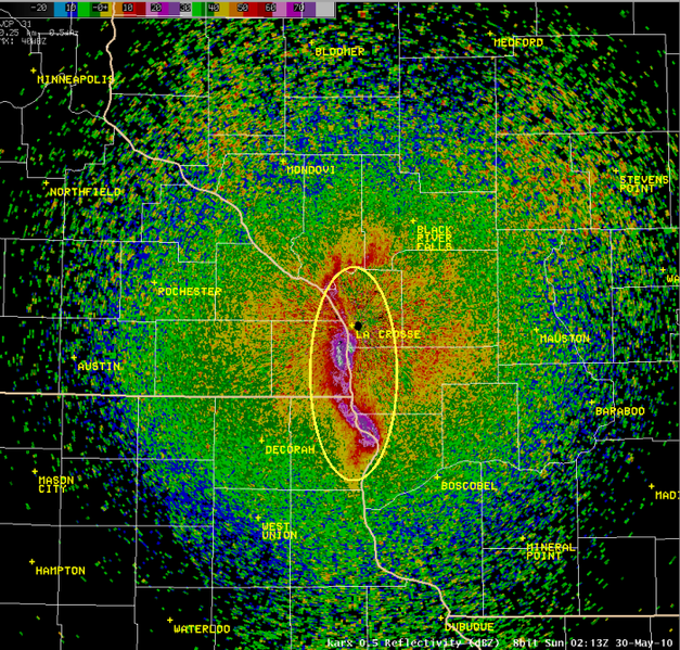
English: Description on source page: A mayfly hatch along the Mississippi River was caught on Doppler weather radar out of NWS (National Weather Service) La Crosse this evening. The radar view below shows an image at 9:13 p.m. CDT on Saturday, May 29, 2010. The bugs are showing up as bright pink, purple, and white colors along the Mississippi River mainly south of La Crosse, WI. After the bugs hatch off the water and river areas, they are caught in the south-southeast winds while airborne for about 10-20 minutes.
Français : Un nuage de points correspondant à une émergence d'éphémères (insectes aquatiques émergeant ensemble par millions), ici le long du fleuve Mississippi, observé pris sur les radars météorologiques à effet doppler du NWS (National Weather Service) en soirée. Cette imagerie radar montre la situation à 21h 13 HAC (le samedi 29 mai 2010). Les échos radar matérialisant la présence du nuage d'insecte apparaissent en couleurs vives rose, violet et blanc. Cette tache correspond à un vaste et épais nuage d'insectes (plusieurs mètres d'épaisseur) formé le long du fleuve Mississippi principalement au sud de La Crosse, WI. Après l'éclosion sur la rivière et ses berges, les éphémères ont été dispersés à proximité des zones humides et de la rivière, ils se sont posés et ont disparu du radar, après avoir été plus ou moins dispersés par des vents de sud-sud-est en environ 10-20 minutes. |
| Date | |
| Source | http://www.crh.noaa.gov/news/display_cmsstory.php?wfo=arx&storyid=53064&source=0 (dead link; archived) |
| Author | National Weather Service - La Crosse, Wisconsin |
Licensing
[edit]| Public domainPublic domainfalsefalse |
| This file is in the public domain in the United States because it was solely created by the National Weather Service (NWS), including its name from 1870–1970, the United States Weather Bureau (USWB).
This includes the sub-branches of the National Weather Service:
As a file created by an employee of the NWS (formerly USWB) in the course of their official duties, whether hosted
this work is in the public domain in the United States because it is a work prepared by an officer or employee of the United States Government as part of that person’s official duties under the terms of Title 17, Chapter 1, Section 105 of the US Code. |
 | |
 |
Warnings: (Click here to view)
|
File history
Click on a date/time to view the file as it appeared at that time.
| Date/Time | Thumbnail | Dimensions | User | Comment | |
|---|---|---|---|---|---|
| current | 15:58, 7 June 2010 |  | 700 × 669 (748 KB) | Mulad (talk | contribs) | {{Information |Description={{en|1=Description on source page: :A mayfly hatch along the Mississippi River was caught on Doppler radar out of NWS La Crosse this evening. The radar view below shows an image at 9:13 p.m. CDT on Saturday, May 29, 2010. The |
You cannot overwrite this file.
File usage on Commons
There are no pages that use this file.
File usage on other wikis
The following other wikis use this file:
- Usage on af.wikipedia.org
- Usage on bs.wikipedia.org
- Usage on ceb.wikipedia.org
- Usage on cs.wikinews.org
- Usage on en.wiktionary.org
- Usage on fr.wikipedia.org
- Usage on my.wikipedia.org
- Usage on simple.wikipedia.org