File:Medieval, Millstone (FindID 852591).jpg
Original file (3,543 × 2,657 pixels, file size: 5.19 MB, MIME type: image/jpeg)
Captions
Captions
Summary
[edit].jpg&action=edit§ion=1)
| Medieval: Millstone | |||
|---|---|---|---|
| Photographer |
Birmingham Museums Trust, Peter Reavill, 2017-06-13 17:05:19 |
||
| Title |
Medieval: Millstone |
||
| Description |
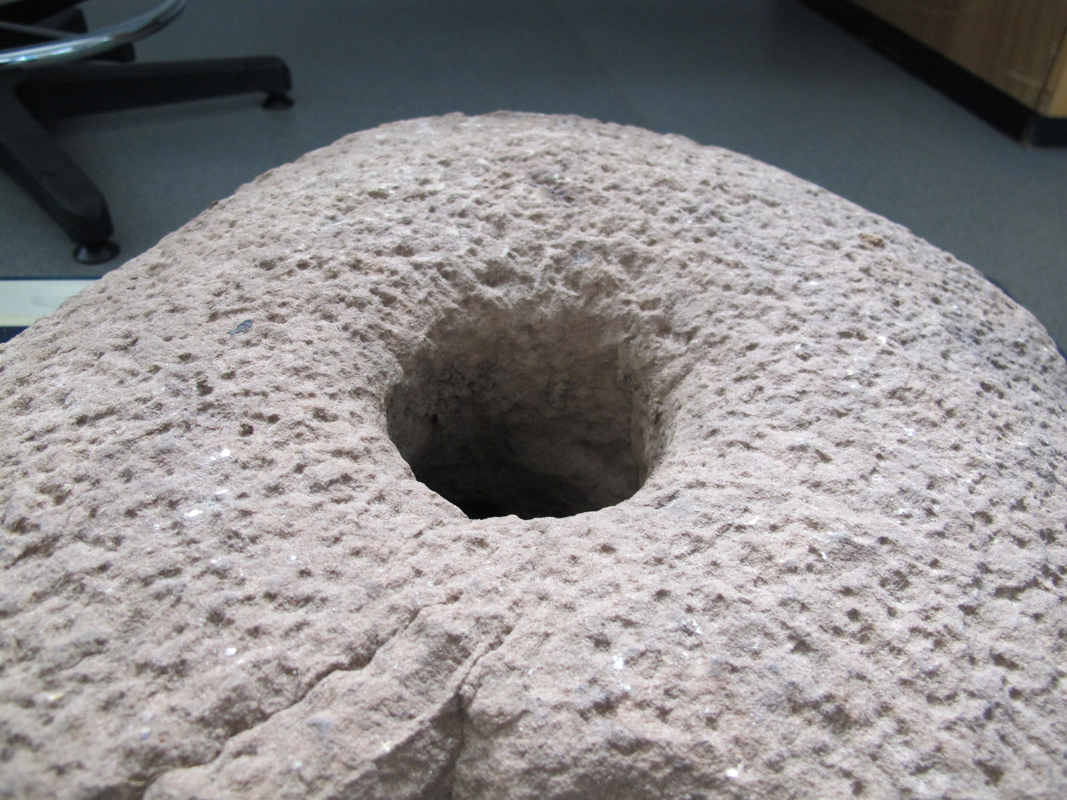
English: A small millstone or large quern stone of probable later medieval date (AD 1250-1600). The stone is incomplete being broadly oval in plan and D shaped in cross section. Significant stone is lost around the edges due to fracturing possibly through heat (there are blackened sooted marks in places) or frost action. The upper surface has a rough pecked surface; this has been created by cold chisel working creating a rough and regular pattern. This working extends into the central hole which is oval in shape. The hole measures 8cm length and 9 cm width. The underside of the stone is smooth and has a polished surface through repeated wear. / use
The stone that forms the millstone is local to South Shropshire. It has been identified by Prof Michael Rosenbaum as being a coarse 'Cornbrook sandstone' which was laid down in the Upper Devonian 400,000,000 years and 350,000,000 years ago and underlying the carboniferous coal measure deposits. This stone is allied to the Millstone grits (although it tends to be more friable) . Exposures of Cornbrook sandstone are relatively common on Clee Hill and therefore it is likely to come from a 'day working' site nearby. Importantly, there is no evidence for the use of this stone in the medieval archaeological record and therefore suggests that the resource was probably only used infrequently and its distribution extends locally. The findspot falls within the area where exposures of Cornbrook sandstone is most common. The millstone measures 46cm length, 42 cm width and is 12.5cm thick. It was too heavy to weigh accurately - an estimate of its weight was approximately 15-20 kilograms. Thanks are extended to Prof Rosenbaum for his help in identifying the stone and additional information he provided - a useful summary of the geology of this area can be seen in his online paper with Prof Brian Wilkinson - published by Shropshire Geological Society: <a href="http://www.shropshiregeology.org.uk/sgspublications/Trail%20Guides/Geological%20Trail%20for%20Titterstone%20Clee.pdf">http://www.shropshiregeology.org.uk/sgspublications/Trail%20Guides/Geological%20Trail%20for%20Titterstone%20Clee.pdf</a> |
||
| Depicted place | (County of findspot) Shropshire | ||
| Date | between 1200 and 1600 | ||
| Accession number |
FindID: 852591 Old ref: HESH-FFCB4A Filename: HESHFFCB4A_detail.jpg |
||
| Credit line |
|
||
| Source |
https://finds.org.uk/database/ajax/download/id/618784 Catalog: https://finds.org.uk/database/images/image/id/618784/recordtype/artefacts archive copy at the Wayback Machine Artefact: https://finds.org.uk/database/artefacts/record/id/852591 |
||
| Permission (Reusing this file) |
Attribution License | ||
| Object location | | View this and other nearby images on: OpenStreetMap |
|---|
.jpg¶ms=052.358800_N_-002.605500_E_globe:Earth_class:object_type:object__&language=en)
Licensing
[edit].jpg&action=edit§ion=2)
- You are free:
- to share – to copy, distribute and transmit the work
- to remix – to adapt the work
- Under the following conditions:
- attribution – You must give appropriate credit, provide a link to the license, and indicate if changes were made. You may do so in any reasonable manner, but not in any way that suggests the licensor endorses you or your use.
File history
Click on a date/time to view the file as it appeared at that time.
| Date/Time | Thumbnail | Dimensions | User | Comment | |
|---|---|---|---|---|---|
| current | 11:21, 15 December 2018 | | 3,543 × 2,657 (5.19 MB) | Fæ (talk | contribs) | Portable Antiquities Scheme, HESH, FindID: 852591, medieval, page 1510, batch count 5400 |
You cannot overwrite this file.
File usage on Commons
The following page uses this file:
.jpg)
.jpg&oldid=632283282)