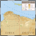
File:Mappa del Nord Africa 1941 - 1942.svg
From Wikimedia Commons, the free media repository
Jump to navigation
Jump to search

Size of this PNG preview of this SVG file: 600 × 600 pixels. Other resolutions: 240 × 240 pixels | 480 × 480 pixels | 768 × 768 pixels | 1,024 × 1,024 pixels | 2,048 × 2,048 pixels | 1,175 × 1,175 pixels.
Original file (SVG file, nominally 1,175 × 1,175 pixels, file size: 7.28 MB)
File information
Structured data
Captions
Captions
Add a one-line explanation of what this file represents
Summary
[edit]| DescriptionMappa del Nord Africa 1941 - 1942.svg | Situazione politico-geografica del Nord Est Africano tra Libia e l’Egitto, futuro teatro di battaglia della Cirenaica del 1941-1942. |
| Date | 08-11-2020 |
| Source | Own work based on: 1940 German military map - Übersichtskarte Athen-Alexandrien.jpg, 1912 map - Le nuove province Italiane - Tripolitania e Cirenaica.jpg, 1912 map - Carta della Tripolitania e Cirenaica.jpg and WesternDesertBattle Area1941 en.svg |
| Author | User:MacMoreno |
Licensing
[edit]This file is licensed under the Creative Commons Attribution-Share Alike 4.0 International license.
- You are free:
- to share – to copy, distribute and transmit the work
- to remix – to adapt the work
- Under the following conditions:
- attribution – You must give appropriate credit, provide a link to the license, and indicate if changes were made. You may do so in any reasonable manner, but not in any way that suggests the licensor endorses you or your use.
- share alike – If you remix, transform, or build upon the material, you must distribute your contributions under the same or compatible license as the original.
File history
Click on a date/time to view the file as it appeared at that time.
| Date/Time | Thumbnail | Dimensions | User | Comment | |
|---|---|---|---|---|---|
| current | 21:57, 21 November 2020 |  | 1,175 × 1,175 (7.28 MB) | MacMoreno (talk | contribs) | Cambiamento Titolo della didascalia |
| 22:56, 13 November 2020 |  | 1,175 × 1,175 (7.29 MB) | MacMoreno (talk | contribs) | Alleggerimento Mb | |
| 22:43, 13 November 2020 |  | 1,175 × 1,175 (15.34 MB) | MacMoreno (talk | contribs) | Correzioni grafiche | |
| 18:56, 8 November 2020 |  | 1,134 × 1,134 (7.26 MB) | MacMoreno (talk | contribs) | Piccole correzioni | |
| 18:44, 8 November 2020 |  | 1,134 × 1,134 (7.26 MB) | MacMoreno (talk | contribs) | {{Information |Description= Situazione politico-geografica del Nord Est Africano tra Libia e l’Egitto, futuro teatro di battaglia della Cirenaica del 1941-1942. |Source= Liberamente tratta da: File:1940_German_military_map_-_Übersichtskarte_Athen-Alexandrien.jpg - File:1912 map - Le nuove province Italiane - Tripolitania e Cirenaica.jpg - File:1912 map - Carta della Tripolitania e Cirenaica.jpg |Date=08-11-2020 |Author=User:MacMoreno |Permission= |other_versions={{DerivativeVersions|Afri... |
You cannot overwrite this file.
File usage on Commons
The following page uses this file:
File usage on other wikis
The following other wikis use this file:
- Usage on it.wikipedia.org
Metadata
This file contains additional information such as Exif metadata which may have been added by the digital camera, scanner, or software program used to create or digitize it. If the file has been modified from its original state, some details such as the timestamp may not fully reflect those of the original file. The timestamp is only as accurate as the clock in the camera, and it may be completely wrong.
| Width | 1174.8583984px |
|---|---|
| Height | 1174.8583984px |
Structured data
Items portrayed in this file
depicts
Hidden category: