File:Mapa prus.svg
Jump to navigation
Jump to search

Size of this PNG preview of this SVG file: 755 × 565 pixels. Other resolutions: 320 × 239 pixels | 640 × 479 pixels | 1,024 × 766 pixels | 1,280 × 958 pixels | 2,560 × 1,916 pixels.
Original file (SVG file, nominally 755 × 565 pixels, file size: 166 KB)
Captions
Captions
Add a one-line explanation of what this file represents
Summary
[edit]
| Description |
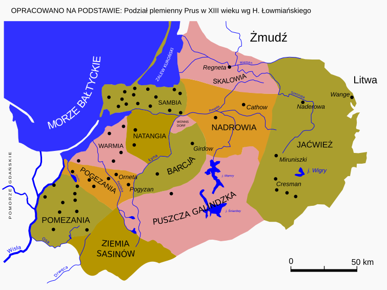
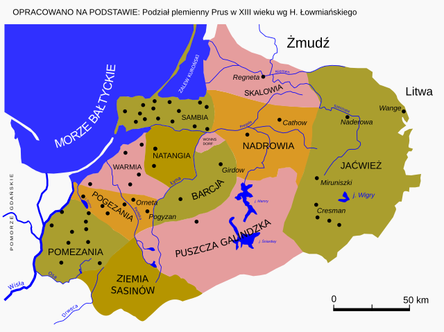
Polski: Podział plemienny Prus w XIII wieku wg H. Łowmiańskiego |
||
| Date | |||
| Source | Own work, based on Podział plemienny Prus w XIII wieku, H. Łowmiański | ||
| Author | Telewizjamsi | ||
| Permission (Reusing this file) |
|
File history
Click on a date/time to view the file as it appeared at that time.
| Date/Time | Thumbnail | Dimensions | User | Comment | |
|---|---|---|---|---|---|
| current | 13:29, 29 August 2022 | | 755 × 565 (166 KB) | JakaśKreatywnaNazwa (talk | contribs) | Poprawiono tekst |
| 18:47, 9 June 2022 |  | 755 × 565 (427 KB) | JakaśKreatywnaNazwa (talk | contribs) | Korekta | |
| 14:46, 5 June 2022 |  | 755 × 565 (427 KB) | JakaśKreatywnaNazwa (talk | contribs) | Dodano brakujący obszar Sasinii wraz z otaczającymi ją rzekami | |
| 19:39, 23 September 2010 |  | 768 × 522 (133 KB) | ToSter (talk | contribs) | Jaćwież | |
| 10:04, 29 June 2008 |  | 768 × 522 (137 KB) | Telewizjamsi (talk | contribs) | {{Information |Description= |Source= |Date= |Author= |Permission= |other_versions= }} Category:Prussia-Maps | |
| 10:02, 29 June 2008 |  | 768 × 522 (152 KB) | Telewizjamsi (talk | contribs) | {{Information |Description= |Source= |Date= |Author= |Permission= |other_versions= }} Category:Prussia-Maps | |
| 13:00, 25 June 2008 |  | 768 × 522 (146 KB) | Telewizjamsi (talk | contribs) | OPRACOWANO NA PODSTAWIE: Podział plemienny Prus w XIII wieku wg H. Łowmiańskiego | |
| 12:57, 25 June 2008 |  | 768 × 522 (132 KB) | Telewizjamsi (talk | contribs) | OPRACOWANO NA PODSTAWIE: Podział plemienny Prus w XIII wieku wg H. Łowmiańskiego | |
| 12:41, 25 June 2008 |  | 768 × 522 (143 KB) | Telewizjamsi (talk | contribs) | OPRACOWANO NA PODSTAWIE: Podział plemienny Prus w XIII wieku wg H. Łowmiańskiego | |
| 12:01, 22 June 2008 |  | 768 × 522 (74 KB) | Telewizjamsi (talk | contribs) | {{Information |Description={{pl|1=PRUSY XIII WIEK}} |Source=Praca własna osoby przesyłającej (own work by uploader) |Author=Telewizjamsi |Date=2008 |Permission= |other_versions= }} {{ImageUpload|full}} Category:Prussia-Maps |
You cannot overwrite this file.
File usage on Commons
The following 10 pages use this file:
- User:Magog the Ogre/Multilingual legend/2022 August 21-31
- User:Magog the Ogre/Multilingual legend/2022 June 1-10
- File:Barcja na mapie adm. Polski i Rosji.svg
- File:Mapa prus-pt.svg
- File:Pogezania na mapie adm. Polski.svg
- File:Pomezania na mapie adm. Polski.svg
- File:Prusy plemienne na mapie adm. Polski, Rosji i Litwy.svg
- File:Sasinia na mapie adm. Polski.svg
- File:Warmia biskupia i plemienna na mapie adm. Polski i Rosji.svg
- File:Warmia plemienna na mapie adm. Polski i Rosji.svg
File usage on other wikis
The following other wikis use this file:
- Usage on io.wikipedia.org
- Usage on lt.wikipedia.org
- Usage on pl.wikipedia.org
- Usage on pl.wiktionary.org
- Usage on ru.wikipedia.org
- Usage on uk.wikipedia.org