File:Map of the Niger–Congo languages.svg
Jump to navigation
Jump to search

Size of this PNG preview of this SVG file: 717 × 600 pixels. Other resolutions: 287 × 240 pixels | 574 × 480 pixels | 918 × 768 pixels | 1,224 × 1,024 pixels | 2,447 × 2,048 pixels | 1,342 × 1,123 pixels.
Original file (SVG file, nominally 1,342 × 1,123 pixels, file size: 1.09 MB)
Captions
Captions
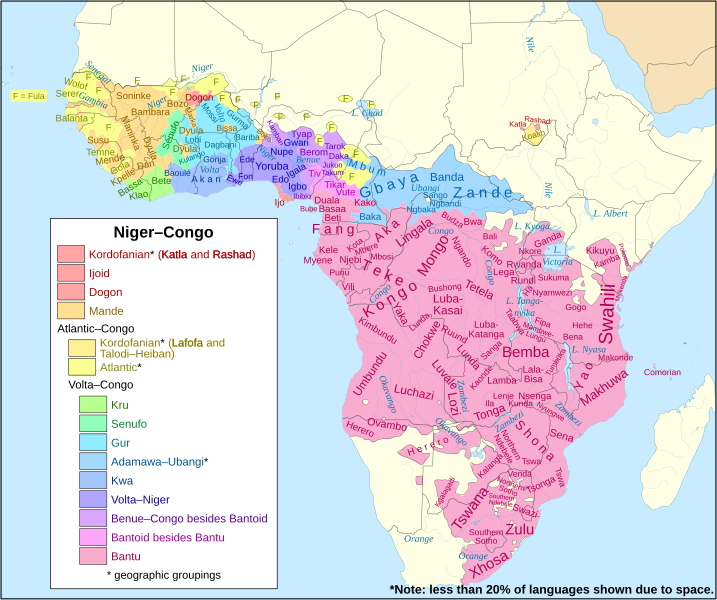
Map of the Niger-Congo language family
Summary
[edit]
| Description |
English: Clickable map of the Niger–Congo language family, its subfamilies and its major languages Bantu languages |
| Date | |
| Source | Created from File:Africa_map_blank.svg. Based on design of File:Map_of_the_Niger-Congo_and_Khoisan_languages.svg. |
| Author |
|
Licensing
[edit]
This file is licensed under the Creative Commons Attribution-Share Alike 4.0 International license.
- You are free:
- to share – to copy, distribute and transmit the work
- to remix – to adapt the work
- Under the following conditions:
- attribution – You must give appropriate credit, provide a link to the license, and indicate if changes were made. You may do so in any reasonable manner, but not in any way that suggests the licensor endorses you or your use.
- share alike – If you remix, transform, or build upon the material, you must distribute your contributions under the same or compatible license as the original.
File history
Click on a date/time to view the file as it appeared at that time.
| Date/Time | Thumbnail | Dimensions | User | Comment | |
|---|---|---|---|---|---|
| current | 20:50, 1 June 2018 | | 1,342 × 1,123 (1.09 MB) | SUM1 (talk | contribs) | Added note and fixed key |
| 15:16, 18 July 2017 |  | 1,342 × 1,123 (1.09 MB) | SUM1 (talk | contribs) | Fixed southern Bantu boundary | |
| 22:05, 15 July 2017 |  | 1,342 × 1,123 (1.1 MB) | SUM1 (talk | contribs) | Fixed Adamawa–Ubangi boundary | |
| 20:55, 12 July 2017 |  | 1,342 × 1,123 (1.06 MB) | SUM1 (talk | contribs) | Added shading border | |
| 21:16, 10 July 2017 |  | 1,342 × 1,123 (1.04 MB) | SUM1 (talk | contribs) | Fixed extra Katla shading | |
| 21:12, 10 July 2017 |  | 1,342 × 1,123 (1.04 MB) | SUM1 (talk | contribs) | Fixed layer of Kordofanian shading | |
| 21:01, 10 July 2017 |  | 1,342 × 1,123 (1.04 MB) | SUM1 (talk | contribs) | Fixed Kordofanian classification | |
| 16:00, 10 July 2017 |  | 1,342 × 1,123 (1.03 MB) | SUM1 (talk | contribs) | Fixed Bantu and Adamawa–Ubangi boundaries | |
| 00:59, 10 July 2017 |  | 1,342 × 1,123 (1.03 MB) | SUM1 (talk | contribs) | User created page with UploadWizard |
You cannot overwrite this file.
File usage on Commons
The following 5 pages use this file:
File usage on other wikis
The following other wikis use this file:
- Usage on ast.wikipedia.org
- Usage on bcl.wikipedia.org
- Usage on ca.wikipedia.org
- Usage on de.wikipedia.org
- Usage on diq.wikipedia.org
- Usage on en.wikipedia.org
- Usage on en.wikiversity.org
- Usage on fa.wikipedia.org
- Usage on fr.wikipedia.org
- Usage on gl.wikipedia.org
- Usage on ha.wikipedia.org
- Usage on hif.wikipedia.org
- Usage on id.wikipedia.org
- Usage on ie.wikipedia.org
- Usage on lfn.wikipedia.org
- Usage on lij.wikipedia.org
- Usage on mg.wikipedia.org
- Usage on mzn.wikipedia.org
- Usage on ne.wikipedia.org
- Usage on nqo.wikipedia.org
- Usage on ro.wikipedia.org
- Usage on ru.wikipedia.org
- Usage on sat.wikipedia.org
- Usage on sl.wikipedia.org
- Usage on sn.wikipedia.org
- Usage on th.wikipedia.org
- Usage on tr.wikipedia.org
- Usage on ur.wikipedia.org
- Usage on uz.wikipedia.org
- Usage on www.wikidata.org