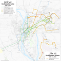
File:Map of the Cairo and Helwan tramways with topography.png

Original file (4,245 × 4,292 pixels, file size: 5.31 MB, MIME type: image/png)
Captions
Captions
| DescriptionMap of the Cairo and Helwan tramways with topography.png |
Deutsch: Karte der Sraßenbahnen Kairo und Helwan
English: Map of the Cairo and Helwan tramways
Français : Carte des tramways du Caire et du Helwan |
| Date | see file history |
| Source |
Own work, using OpenStreetMap data for the background. Information is taken from these sources:
|
| Author | Maximilian Dörrbecker (Chumwa) |
| Permission (Reusing this file) |
I, the copyright holder of this work, hereby publish it under the following license: This file is licensed under the Creative Commons Attribution-Share Alike 2.5 Generic license.
Sie dürfen das Bild zu den folgenden Bedingungen nutzen:
|
| Other versions |
|
File history
Click on a date/time to view the file as it appeared at that time.
| Date/Time | Thumbnail | Dimensions | User | Comment | |
|---|---|---|---|---|---|
| current | 20:33, 28 November 2019 |  | 4,245 × 4,292 (5.31 MB) | Chumwa (talk | contribs) | Trolleybusnetz 1961 ergänzt |
| 10:01, 27 May 2018 |  | 5,189 × 5,247 (6.98 MB) | Chumwa (talk | contribs) | ||
| 06:59, 3 February 2016 |  | 4,245 × 4,292 (5.81 MB) | Chumwa (talk | contribs) | ||
| 22:23, 2 February 2016 |  | 4,245 × 4,292 (5.81 MB) | Chumwa (talk | contribs) | {{Information |Description= {{de|Karte der Sraßenbahnen Kairo und Helwan}} {{en|Map of the Cairo and Helwan tramways}} {{fr|Carte des tramways du Caire et du Helwan}} |Source={{Own}} information is taken from these sources: * Martin Pabst: Tram & Tro... |
You cannot overwrite this file.
File usage on Commons
The following 16 pages use this file:
- User:Chumwa/Gallery
- User:Chumwa/OgreBot/Potential transport maps/2016 February 1-9
- User:Chumwa/OgreBot/Potential transport maps/2018 May 21-31
- User:Chumwa/OgreBot/Potential transport maps/2019 November 21-30
- User:Chumwa/OgreBot/Public transport information/2016 February 1-9
- User:Chumwa/OgreBot/Public transport information/2018 May 21-31
- User:Chumwa/OgreBot/Public transport information/2019 November 21-30
- User:Chumwa/OgreBot/Transport Maps/2016 February 1-9
- User:Chumwa/OgreBot/Transport Maps/2018 May 21-31
- User:Chumwa/OgreBot/Transport Maps/2019 November 21-30
- User:Chumwa/OgreBot/Travel and communication maps/2016 February 1-9
- User:Chumwa/OgreBot/Travel and communication maps/2018 May 21-31
- File:Map of the Cairo and Helwan tramways.png
- File:Map of the Cairo and Helwan tramways with topography.png
- File:StrassenbahnGleisplanKairo1996.png
- File:StrassenbahnNetzplanKairo1996.png
File usage on other wikis
The following other wikis use this file:
- Usage on de.wikipedia.org
- Usage on ja.wikipedia.org
Metadata
This file contains additional information such as Exif metadata which may have been added by the digital camera, scanner, or software program used to create or digitize it. If the file has been modified from its original state, some details such as the timestamp may not fully reflect those of the original file. The timestamp is only as accurate as the clock in the camera, and it may be completely wrong.
| Horizontal resolution | 39.37 dpc |
|---|---|
| Vertical resolution | 39.37 dpc |
| Software used |


