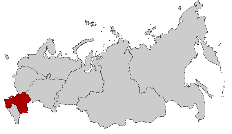
File:Map of Russia - Southern Federal District.svg
From Wikimedia Commons, the free media repository
Jump to navigation
Jump to search

Size of this PNG preview of this SVG file: 800 × 462 pixels. Other resolutions: 320 × 185 pixels | 640 × 369 pixels | 1,024 × 591 pixels | 1,280 × 738 pixels | 2,560 × 1,477 pixels | 1,092 × 630 pixels.
Original file (SVG file, nominally 1,092 × 630 pixels, file size: 118 KB)
File information
Structured data
Captions
Captions
Add a one-line explanation of what this file represents
| DescriptionMap of Russia - Southern Federal District.svg |
English: Map Russia highlighting the Southern Federal districts.
Español: Ubicación del Distrito Federal Sur en la Federación Rusa
Русский: Южный федеральный округ |
| Date | |
| Source | Based on Map of Russian subjects, 2008-03-01.svg by Lokal_Profil |
| Author | Lokal_Profil |
| Permission (Reusing this file) |
This file is licensed under the Creative Commons Attribution-Share Alike 2.5 Generic license.
|
| Other versions |
|
File history
Click on a date/time to view the file as it appeared at that time.
| Date/Time | Thumbnail | Dimensions | User | Comment | |
|---|---|---|---|---|---|
| current | 16:20, 28 July 2016 |  | 1,092 × 630 (118 KB) | Konstrooktor (talk | contribs) | Contained territories of other countries. Reverted to version as of 21:47, 21 January 2010 (UTC) |
| 16:19, 28 July 2016 |  | 1,092 × 630 (118 KB) | Konstrooktor (talk | contribs) | Contained territories of other countries. Reverted to version as of 21:47, 21 January 2010 (UTC) | |
| 15:32, 28 July 2016 |  | 1,092 × 630 (95 KB) | APh (talk | contribs) | Borders of Southern Federal District since 2016-07-28. | |
| 15:29, 28 July 2016 |  | 1,092 × 630 (95 KB) | APh (talk | contribs) | Borders of Southern Federal District since 2016-07-28. | |
| 14:25, 10 March 2015 |  | 1,092 × 630 (95 KB) | Knyaz-1988 (talk | contribs) | Reverted to version as of 22:09, 3 November 2014 | |
| 01:32, 4 November 2014 |  | 1,092 × 630 (118 KB) | Fry1989 (talk | contribs) | NPOV issue. | |
| 22:09, 3 November 2014 |  | 1,092 × 630 (95 KB) | Knyaz-1988 (talk | contribs) | New version | |
| 21:47, 21 January 2010 |  | 1,092 × 630 (118 KB) | Denhud (talk | contribs) | Borders of Southern Federal District since 2010-01-19. | |
| 23:36, 3 March 2008 |  | 1,092 × 630 (112 KB) | Lokal Profil (talk | contribs) | {{Information |Description=Map Russia highlighting the Southern Federal districts. |Source=Based on Map of Russian subjects, 2008-03-01.svg by [[:user:Lokal_Profil|Loka |
You cannot overwrite this file.
File usage on Commons
The following 6 pages use this file:
- User:Lokal Profil/gallery
- File:Map of Russia - Southern Federal District (2000-2010).svg
- File:Map of Russia - Southern Federal District (2014-2016, with Crimea).svg
- File:Map of Russia - Southern Federal District (with Crimea).svg
- File:Map of Russia - Southern Federal District (with Crimea claimed).svg
- File:RussiaNorthernCaucasus.png
File usage on other wikis
The following other wikis use this file:
- Usage on bs.wikipedia.org
- Usage on el.wikipedia.org
- Usage on en.wikipedia.org
- Usage on es.wikipedia.org
- Usage on eu.wikipedia.org
- Usage on hr.wikipedia.org
- Usage on hy.wikipedia.org
- Usage on ka.wikipedia.org
- Usage on koi.wikipedia.org
- Usage on mn.wikipedia.org
- Usage on mr.wikipedia.org
- Usage on ms.wikipedia.org
- Usage on pfl.wikipedia.org
- Usage on ru.wikipedia.org
- Usage on sv.wikipedia.org
- Usage on tl.wikipedia.org
- Usage on tr.wikipedia.org
- Usage on uk.wikipedia.org
- Usage on www.wikidata.org
- Usage on xmf.wikipedia.org
Metadata
This file contains additional information such as Exif metadata which may have been added by the digital camera, scanner, or software program used to create or digitize it. If the file has been modified from its original state, some details such as the timestamp may not fully reflect those of the original file. The timestamp is only as accurate as the clock in the camera, and it may be completely wrong.
| Width | 1091.9919 |
|---|---|
| Height | 630.11902 |
Hidden category:


