File:Map of Morrow Co., Ohio LOC 2012592245.jpg
Jump to navigation
Jump to search

Size of this preview: 649 × 600 pixels. Other resolutions: 260 × 240 pixels | 519 × 480 pixels | 831 × 768 pixels | 1,108 × 1,024 pixels | 2,216 × 2,048 pixels | 16,125 × 14,902 pixels.
Original file (16,125 × 14,902 pixels, file size: 33.64 MB, MIME type: image/jpeg)
Captions
Captions
Add a one-line explanation of what this file represents
Summary
[edit]| Warning | The original file is very high-resolution. It might not load properly or could cause your browser to freeze when opened at full size. |
|---|
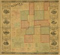
| Description |
English: LC Land ownership maps, 660 Available also through the Library of Congress Web site as a raster image. Includes population statistical tables, views of public, commercial, and residential properties. Inset: Chesterfield -- Woodbury -- Iberia -- Pulaski -- Sparta -- South Woodbury -- Williamsport -- Cardington -- West Liberty -- Denmark -- Westfield -- Bloomfield -- Page-town -- Mt. Gilead. LC copy imperfect: Use-worn, sectioned to 6 panels to enable folding, torn at fold lines. |
||
| Title | Map of Morrow Co., Ohio | ||
| Shelf ID | G4083.M8G46 1857 .H3 | ||
| Date | |||
| Source | https://www.loc.gov/item/2012592245/ | ||
| Author | Harwood & Watson; Woodford & Bartlett; Friend & Aub | ||
| Permission (Reusing this file) |
|
||
| Other versions |
|
||
| Location | United States · Morrow County · Ohio | ||
| Part of | American Memory · Catalog · County Landownership Maps · Geography And Map Division · Cultural Landscapes | ||
| Subject | Cadastral Maps · Morrow County · Cities And Towns · United States · Maps · Ohio · Real Property · Landowners |

Licensing
[edit]
|
This is a faithful photographic reproduction of a two-dimensional, public domain work of art. The work of art itself is in the public domain for the following reason:
The official position taken by the Wikimedia Foundation is that "faithful reproductions of two-dimensional public domain works of art are public domain".
This photographic reproduction is therefore also considered to be in the public domain in the United States. In other jurisdictions, re-use of this content may be restricted; see Reuse of PD-Art photographs for details. | ||||
File history
Click on a date/time to view the file as it appeared at that time.
| Date/Time | Thumbnail | Dimensions | User | Comment | |
|---|---|---|---|---|---|
| current | 03:43, 6 June 2018 | | 16,125 × 14,902 (33.64 MB) | Fæ (talk | contribs) | LOC Maps https://www.loc.gov/item/2012592245/ #6291 |
You cannot overwrite this file.
File usage on Commons
The following page uses this file: