File:Map of Central America.svg
Jump to navigation
Jump to search

Size of this PNG preview of this SVG file: 412 × 294 pixels. Other resolutions: 320 × 228 pixels | 640 × 457 pixels | 1,024 × 731 pixels | 1,280 × 913 pixels | 2,560 × 1,827 pixels.
Original file (SVG file, nominally 412 × 294 pixels, file size: 2.27 MB)
Captions
Captions
Add a one-line explanation of what this file represents
Summary
[edit]
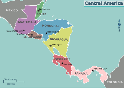
| Description | Map of Central America for use on Wikivoyage, multilingual SVG file |
| Date | |
| Source | Own work based on the blank world map |
| Author | Cacahuate, translations by Joelf, Globe-trotter and Piet-c. |
| Other versions |
PNG files |
| Other information |
.png)
.png)
Licensing
[edit]
This file is licensed under the Creative Commons Attribution-Share Alike 4.0 International, 3.0 Unported, 2.5 Generic, 2.0 Generic and 1.0 Generic license.
- You are free:
- to share – to copy, distribute and transmit the work
- to remix – to adapt the work
- Under the following conditions:
- attribution – You must give appropriate credit, provide a link to the license, and indicate if changes were made. You may do so in any reasonable manner, but not in any way that suggests the licensor endorses you or your use.
- share alike – If you remix, transform, or build upon the material, you must distribute your contributions under the same or compatible license as the original.
Original upload log
[edit]
| This file was imported from Wikivoyage WTS. |
The original description page was here. All following user names refer to wts.wikivoyage-old.
- 2010-09-26 17:19 (WT-shared) Cacahuate[dead link] 744×1052 (2321933 bytes) == Summary == {{Imagecredit| credit=[[User:Cacahuate|Cacahuate]], [[User:Mark|Mark]] (WT logo) |captureDate=August 2nd, 2008 |location=Centr (Import from wikitravel.org/shared)
- 2010-10-31 04:32 (WT-shared) Joelf[dead link] 412×294 (2027252 bytes) (Import from wikitravel.org/shared)
- 2010-11-07 01:26 (WT-shared) Joelf[dead link] 412×294 (2048489 bytes) +fr Reorganized language sublayers. (Import from wikitravel.org/shared)
- 2012-09-09 05:16 Shaund[dead link] 412×294 (2050662 bytes) rmv logo
- 2012-09-13 11:42 ImportBot[dead link] 412×294 (2033554 bytes) rm WT-logo
- 2012-09-19 23:23 Globe-trotter[dead link] 412×294 (2201994 bytes) +nl
File history
Click on a date/time to view the file as it appeared at that time.
| Date/Time | Thumbnail | Dimensions | User | Comment | |
|---|---|---|---|---|---|
| current | 08:03, 2 August 2013 | | 412 × 294 (2.27 MB) | Piet-c (talk | contribs) | [eo]: Aldono de Esperanto. |
| 20:56, 26 November 2012 |  | 412 × 294 (2.1 MB) | OgreBot (talk | contribs) | (BOT): Reverting to most recent version before archival | |
| 20:56, 26 November 2012 |  | 412 × 294 (1.94 MB) | OgreBot (talk | contribs) | (BOT): Uploading old version of file from wts.wikivoyage-old; originally uploaded on 2012-09-13 11:42:38 by ImportBot | |
| 20:56, 26 November 2012 |  | 412 × 294 (1.96 MB) | OgreBot (talk | contribs) | (BOT): Uploading old version of file from wts.wikivoyage-old; originally uploaded on 2012-09-09 05:16:54 by Shaund | |
| 20:56, 26 November 2012 |  | 412 × 294 (1.95 MB) | OgreBot (talk | contribs) | (BOT): Uploading old version of file from wts.wikivoyage-old; originally uploaded on 2010-11-07 01:26:01 by (WT-shared) Joelf | |
| 20:56, 26 November 2012 |  | 412 × 294 (1.93 MB) | OgreBot (talk | contribs) | (BOT): Uploading old version of file from wts.wikivoyage-old; originally uploaded on 2010-10-31 04:32:25 by (WT-shared) Joelf | |
| 20:56, 26 November 2012 |  | 744 × 1,052 (2.21 MB) | OgreBot (talk | contribs) | (BOT): Uploading old version of file from wts.wikivoyage-old; originally uploaded on 2010-09-26 17:19:49 by (WT-shared) Cacahuate | |
| 00:56, 18 November 2012 |  | 412 × 294 (2.1 MB) | MGA73bot2 (talk | contribs) | {{BotMoveToCommons|wts.oldwikivoyage|year={{subst:CURRENTYEAR}}|month={{subst:CURRENTMONTHNAME}}|day={{subst:CURRENTDAY}}}} == {{int:filedesc}} == {{Information |description=Map of Central America. '''PNG versions:''' <br>Dutch version: [[:wts::Image:M... |
You cannot overwrite this file.
File usage on Commons
The following 3 pages use this file:
.png)
.png)
File usage on other wikis
The following other wikis use this file:
- Usage on ja.wikipedia.org
- Usage on pt.wikinews.org
- Nicarágua e Honduras entram em alerta devido a furacão Eta
- Predefinição:Infotabela América Central
- Furacão Eta toca terra na Nicarágua com ventos de 240km/h
- Furacão Eta deixa rastro de destruição e mortes na Nicarágua e Honduras
- Bukele entregará US$ 75 milhões aos prefeitos pelo furacão Eta
- Furacão Eta matou mais de 100 pessoas na América Central
- Nicarágua e Honduras podem ser atingidas por novo furacão, o Iota
- Iota se transforma num furacão de categoria 5; Nicarágua está em seu caminho
- Um mês depois, Honduras e Nicarágua ainda sofrem com estragos deixados pelos furacões Eta e Iota
- Falta de comida coloca o norte da América Central em maior risco
- Mais de 5 milhões na Guatemala, El Salvador e Honduras em "insegurança alimentar aguda"
- Mais inflação e menor crescimento ofuscam as expectativas econômicas para a América Central em 2022
- Tempestade tropical Bonnie atravessa América Central, causa mortes e vira furacão no Pacífico
- Mais de uma dúzia de mortos e centenas de evacuados pelas fortes chuvas na América Central