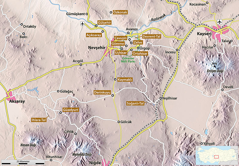
File:Map of Cappadocia.jpg

Original file (2,441 × 1,696 pixels, file size: 2.21 MB, MIME type: image/jpeg)
Captions
Captions
| DescriptionMap of Cappadocia.jpg |
|
| Date | |
| Source |
Own work own work, using data from maps-for-free.com for the topographical background and this file by NNW for the orientation map |
| Author | Maximilian Dörrbecker (Chumwa) |
| Permission (Reusing this file) |
I, the copyright holder of this work, hereby publish it under the following license: This file is licensed under the Creative Commons Attribution-Share Alike 2.5 Generic license.
Sie dürfen das Bild zu den folgenden Bedingungen nutzen:
|
| Other versions |
|
File history
Click on a date/time to view the file as it appeared at that time.
| Date/Time | Thumbnail | Dimensions | User | Comment | |
|---|---|---|---|---|---|
| current | 16:15, 24 August 2009 |  | 2,441 × 1,696 (2.21 MB) | רוליג (talk | contribs) | Reverted to version as of 19:31, 28 June 2009 |
| 16:13, 24 August 2009 |  | 2,441 × 1,696 (2.65 MB) | רוליג (talk | contribs) | m | |
| 16:08, 24 August 2009 |  | 2,441 × 1,696 (2.65 MB) | רוליג (talk | contribs) | m | |
| 16:05, 24 August 2009 |  | 2,441 × 1,696 (2.65 MB) | רוליג (talk | contribs) | m | |
| 19:31, 28 June 2009 |  | 2,441 × 1,696 (2.21 MB) | Chumwa (talk | contribs) | Typos | |
| 15:30, 28 June 2009 |  | 2,441 × 1,696 (2.21 MB) | Chumwa (talk | contribs) | Açıksaray hinzugefügt | |
| 21:57, 27 June 2009 |  | 2,441 × 1,696 (2.21 MB) | Chumwa (talk | contribs) | noch ein bischen rumgepfriemelt... | |
| 20:14, 27 June 2009 |  | 2,441 × 1,696 (2.22 MB) | Chumwa (talk | contribs) | {{Information |Description= *{{ de }} Karte von Kappadokien *{{ en }} Map of Cappadocia *{{ fr }} Carte de la Cappadoce|Source=Self made |Date=Juni 2009 |Author= Maximilian Dörrbecker (Chumwa) |Source= own work, us |
You cannot overwrite this file.
File usage on Commons
The following 5 pages use this file:
File usage on other wikis
The following other wikis use this file:
- Usage on als.wikipedia.org
- Usage on ar.wikipedia.org
- Usage on arz.wikipedia.org
- Usage on ast.wikipedia.org
- Usage on az.wikipedia.org
- Usage on be-tarask.wikipedia.org
- Usage on be.wikipedia.org
- Usage on ca.wikipedia.org
- Usage on cv.wikipedia.org
- Usage on da.wikipedia.org
- Usage on de.wikipedia.org
- Kappadokien
- Göreme
- Benutzer:Chumwa
- Kaymaklı
- Höhlenarchitektur in Kappadokien
- Açıksaray
- Uçhisar
- Zelve
- Ortahisar (Nevşehir)
- Derinkuyu (unterirdische Stadt)
- Klostertal von Güzelyurt
- Ihlara-Tal
- Soğanlı-Tal
- Wikipedia:Kartenwerkstatt/Archiv/2009-06
- Çavuşin
- Wikipedia:Kartenwerkstatt/Karte des Tages/Galerie
- Benutzer:Chumwa/SomeOfMyFiles
- Usage on en.wikipedia.org
- Usage on eo.wikipedia.org
- Usage on es.wikipedia.org
- Usage on fa.wikipedia.org
- Usage on fr.wikipedia.org
- Usage on gl.wikipedia.org
- Usage on he.wikipedia.org
- Usage on hu.wikipedia.org
- Usage on id.wikipedia.org
- Usage on it.wikipedia.org
- Usage on ja.wikipedia.org
- Usage on la.wikipedia.org
- Usage on min.wikipedia.org
View more global usage of this file.
Metadata
This file contains additional information such as Exif metadata which may have been added by the digital camera, scanner, or software program used to create or digitize it. If the file has been modified from its original state, some details such as the timestamp may not fully reflect those of the original file. The timestamp is only as accurate as the clock in the camera, and it may be completely wrong.
| _error | 0 |
|---|


