File:Map liege 1.jpg
Jump to navigation
Jump to search

Size of this preview: 800 × 533 pixels. Other resolutions: 320 × 213 pixels | 640 × 427 pixels | 1,024 × 683 pixels | 1,200 × 800 pixels.
Original file (1,200 × 800 pixels, file size: 182 KB, MIME type: image/jpeg)
Captions
Captions
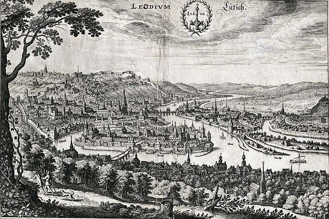
Liège in 1650

Summary
[edit]
"Leodium, Liege, Lütich"
Gravure de Matthäus Merian, c. 1647, dans Topographia Westphaliae das ist Beschreibung..., publié à Francfort.
Vue en perspective cavalière prise des hauteurs de Saint-Gilles et aux armes de la cité de Liège. Les édifices y sont assez fidèlement représentés.
Licensing
[edit]
|
This work is in the public domain in its country of origin and other countries and areas where the copyright term is the author's life plus 70 years or fewer. | |
| This file has been identified as being free of known restrictions under copyright law, including all related and neighboring rights. | |
File history
Click on a date/time to view the file as it appeared at that time.
| Date/Time | Thumbnail | Dimensions | User | Comment | |
|---|---|---|---|---|---|
| current | 00:24, 9 January 2016 | | 1,200 × 800 (182 KB) | The RedBurn (talk | contribs) | Levels corrected with XnView |
| 19:31, 12 November 2006 |  | 1,200 × 800 (133 KB) | Jrenier (talk | contribs) | Better quality, higher resolution. | |
| 14:22, 17 December 2005 |  | 559 × 367 (44 KB) | Jrenier (talk | contribs) | "Leodium, Liege, Lütich" Gravure de Matthaeus Merian, c. 1650, dans Topographia Westphaliae das ist Beschreibung..., publié à Franfort. Vue en perspective cavalière prise des hauteurs de Saint-Gilles et aux armes de la cité de Liège. Les édific |
You cannot overwrite this file.
File usage on Commons
The following page uses this file:
File usage on other wikis
The following other wikis use this file:
- Usage on ceb.wikipedia.org
- Usage on en.wikipedia.org
- Usage on eo.wikipedia.org
- Usage on es.wikipedia.org
- Usage on fr.wikipedia.org
- Usage on hr.wikipedia.org
- Usage on hu.wikipedia.org
- Usage on is.wikipedia.org
- Usage on it.wikipedia.org
- Usage on ja.wikipedia.org
- Usage on ko.wikipedia.org
- Usage on lb.wikipedia.org
- Usage on nl.wikipedia.org
- Usage on pcd.wikipedia.org
- Usage on pl.wikipedia.org
- Usage on pt.wikipedia.org
- Usage on sv.wikipedia.org