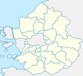
File:Map Gyeonggi-do.png
From Wikimedia Commons, the free media repository
Jump to navigation
Jump to search
Map_Gyeonggi-do.png (365 × 475 pixels, file size: 49 KB, MIME type: image/png)
File information
Structured data
Captions
Captions
Add a one-line explanation of what this file represents

|
Permission is granted to copy, distribute and/or modify this document under the terms of the GNU Free Documentation License, Version 1.2 or any later version published by the Free Software Foundation; with no Invariant Sections, no Front-Cover Texts, and no Back-Cover Texts. A copy of the license is included in the section entitled GNU Free Documentation License.http://www.gnu.org/copyleft/fdl.htmlGFDLGNU Free Documentation Licensetruetrue |
| This file is licensed under the Creative Commons Attribution-Share Alike 3.0 Unported license. | ||
| ||
| This licensing tag was added to this file as part of the GFDL licensing update.http://creativecommons.org/licenses/by-sa/3.0/CC BY-SA 3.0Creative Commons Attribution-Share Alike 3.0truetrue |
made from Maps of Korea.
File history
Click on a date/time to view the file as it appeared at that time.
| Date/Time | Thumbnail | Dimensions | User | Comment | |
|---|---|---|---|---|---|
| current | 15:24, 10 May 2014 |  | 365 × 475 (49 KB) | Geoarchive (talk | contribs) | Correct an error in color of Osan-Si |
| 15:21, 10 May 2014 |  | 365 × 475 (48 KB) | Geoarchive (talk | contribs) | Change Color | |
| 15:15, 10 May 2014 |  | 365 × 475 (45 KB) | Geoarchive (talk | contribs) | Edit distorted and incorrect borders Change Colors | |
| 03:13, 25 June 2011 |  | 300 × 278 (7 KB) | Asfreeas (talk | contribs) | color and form match | |
| 05:45, 15 February 2006 |  | 300 × 278 (6 KB) | Hyolee2 (talk | contribs) | ||
| 05:43, 15 February 2006 |  | 300 × 278 (6 KB) | Hyolee2 (talk | contribs) | daebu island | |
| 12:15, 8 December 2004 |  | 300 × 278 (6 KB) | Cinnamon~commonswiki (talk | contribs) | {{GFDL}}made from Maps of Korea |
You cannot overwrite this file.
File usage on Commons
The following page uses this file:
File usage on other wikis
The following other wikis use this file:
- Usage on ko.wikipedia.org
- 사용자:Airridi/유저박스/지역
- 사용자:Kerriek
- 사용자:Sunseongbum
- 탄천종합운동장
- 사용자:Shqlxk87
- 사용자:김중갈
- 사용자:김중갈/바벨
- 사용자:Jongwan
- 사용자:Cristears
- 사용자:낭만네코
- 사용자:Rvd1212
- 사용자:ARTisRESISTANCE
- 사용자:Fulator
- 사용자:블루클럽
- 사용자:Purecherry
- 사용자:박틱스짱또6/프로필
- 사용자:Chopaksa1019/유저박스
- 사용자:Ziahn
- 사용자:Abcm99
- 사용자:Abcm99/바벨
- 사용자:Ksu9701
- 사용자:Ksu9701/바벨
- 사용자:Dudipoping
- 사용자:Bmh4080/지역
- 사용자:Dudipoping2
- 사용자:Dudipoping3
- 위키백과:대한민국 지도 목록
- 사용자:Bebe~kowiki
- 사용자:Jhcbs1019
- 사용자:Dotorihouse
- 사용자:Chipo7788
- 사용자:Tommy0480
- 사용자:더피 크로반
- 사용자:용인 학생/유저박스목록
- 사용자:유한선
- 사용자:하아~
- Usage on zh.wikipedia.org
Metadata
This file contains additional information such as Exif metadata which may have been added by the digital camera, scanner, or software program used to create or digitize it. If the file has been modified from its original state, some details such as the timestamp may not fully reflect those of the original file. The timestamp is only as accurate as the clock in the camera, and it may be completely wrong.
| Horizontal resolution | 177.17 dpc |
|---|---|
| Vertical resolution | 177.17 dpc |
| Software used |


