File:Map France 1477-fr.svg

Original file (SVG file, nominally 900 × 970 pixels, file size: 1.16 MB)
Captions
Captions
Legends
[edit]Français : Légende
[edit]English: Legend
[edit]|
Red line: Boundary of the Kingdom of France
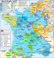
Capetian houses (Valois, Bourbon) : — Duchy of Alençon (1220) — County of Perche (1227) — Duchy of Anjou (1204) — County of Provence (1498) — Duchy of Bar (1766) — County of Maine (1204) — County of Guise (1688) — County of Gien (1199) — Viscounty of Châtellerault (1482) — Duchy of Orléans (987) — Duchy of Valois (1214) — County of Dunois (1707) — County of Longueville (13th century) — Lordship of Parthenay (1419) — County of Angoulême (1308) — Duchy of Bourbon (1531) — Duchy of Auvergne (v. 1200) — County of Forez (1531) — County of Clermont-en-Beauvaisis (1218) — Lordship of Beaujeu (1531) |
Other houses :
House of Burgundy : — Duchy of Burgundy (1016) — County of Charolais (1751) — Sundgau (1648) — Picardy (12-13th centuries) — County of Artois (1185) — County of Hainaut (1659, 1678) — County of Flanders (1678) — Duchy of Brabant (-) — Duchy of Guelders (-) — County of Nevers (?) — County of Rethel (?) — County of Eu (?)
— County of Foix (1589) — County of Bigorre (1322) — Viscounty of Béarn (1589) — Kingdom of Navarre (1589) — Co-Princes of Andorra (-) John of Foix-Étampes, brother of Francis Phoebus : — Viscount of Narbonne (1507) — County of Armagnac (1589) — County of Rodez (1589) — County of Marche (1531) — Duchy of Nemours (1274) — Lordship of Albret (1589) — Viscounty of Limoges (1589) — County of Périgord (1589)
House of Brittany (Francis II, Duke of Brittany) : — Duchy of Brittany (1532) — County of Vertus (1284?) House of Montpensier (Louis I, Count of Montpensier, count of Montpensier et dauphin of Auvergne) : — County of Sancerre (1234) House of Chalon (John of Chalon-d'Arlay) : — Principality of Orange (1673) House of Husson-Tonnerre (Charles de Husson) : — County of Tonnerre (?) House of Lorraine (René II, Duke of Lorraine) : — County of Aumale (1194) ? |
|
— County of Roussillon (1659) — Duchy of Savoy (Bresse, Bugey, Gex : 1601, Savoy : 1860) — Duchy of Lorraine (1766) — Principality of Montbéliard (1793) — County of Blâmont (1766) — Principality of Salm (1793) — Comtat Venaissin, Avignon (Papal States) (1791) — Metz, Verdun and Toul (1552-1648) — Cambrai (1678)
(1589) : year of the first union to royal lands |
Legenda em português
[edit]|
Linha Vermelha:Fronteiras do Reino da França
— Duque de Alençon (1220) — Condes de Perche (1227) — Duque de Anjou (1204) — Condes de Provença (1498) — Duque de Bar (1766) — Condes de Maine (1204) — Condes de Guise (1688) — Condes de Gien (1199) — Viscondes de Châtellerault (1482) — Duque d'Orleães (987) — Duchy of Valois (1214) — County of Dunois (1707) — County of Longueville (13th century) — Lordship of Parthenay (1419) — County of Angoulême (1308) — Duchy of Bourbon (1531) — Duchy of Auvergne (v. 1200) — County of Forez (1531) — County of Clermont-en-Beauvaisis (1218) — Lordship of Beaujeu (1531) |
Other houses :
House of Burgundy : — Duchy of Burgundy (1016) — County of Charolais (1751) — Sundgau (1648) — Picardy (12-13th centuries) — County of Artois (1185) — County of Hainaut (1659, 1678) — County of Flanders (1678) — Duchy of Brabant (-) — Duchy of Guelders (-) — County of Nevers (?) — County of Rethel (?) — County of Eu (?)
— County of Foix (1589) — County of Bigorre (1322) — Viscounty of Béarn (1589) — Kingdom of Navarre (1589) — Co-Princes of Andorra (-) John of Foix-Étampes, brother of Francis Phoebus : — Viscount of Narbonne (1507) — County of Armagnac (1589) — County of Rodez (1589) — County of Marche (1531) — Duchy of Nemours (1274) — Lordship of Albret (1589) — Viscounty of Limoges (1589) — County of Périgord (1589)
House of Brittany (Francis II, Duke of Brittany) : — Duchy of Brittany (1532) — County of Vertus (1284?) House of Montpensier (Louis I, Count of Montpensier, count of Montpensier et dauphin of Auvergne) : — County of Sancerre (1234) House of Chalon (John of Chalon-d'Arlay) : — Principality of Orange (1673) House of Husson-Tonnerre (Charles de Husson) : — County of Tonnerre (?) House of Lorraine (René II, Duke of Lorraine) : — County of Aumale (1194) ? |
|
— County of Roussillon (1659) — Duchy of Savoy (Bresse, Bugey, Gex : 1601, Savoy : 1860) — Duchy of Lorraine (1766) — Principality of Montbéliard (1793) — County of Blâmont (1766) — Principality of Salm (1793) — Comtat Venaissin, Avignon (Papal States) (1791) — Metz, Verdun and Toul (1552-1648) — Cambrai (1678)
(1589) : year of the first union to royal lands |
Summary
[edit]| DescriptionMap France 1477-fr.svg |
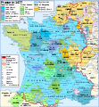
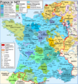
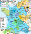
English: Map of France in 1477.
Français : Carte de la France en 1477. |
||||||||
| Date | |||||||||
| Source |
English: Own work. Image renamed from Image:Map France History XVe.svg. Data:
Français : Création personnelle. Image renommée depuis Image:Map France History XVe.svg. Données :
|
||||||||
| Author | Zigeuner | ||||||||
| Permission (Reusing this file) |
I, the copyright holder of this work, hereby publish it under the following licenses:
This file is licensed under the Creative Commons Attribution-Share Alike 2.5 Generic license.
You may select the license of your choice. |
||||||||
| Other versions |
Derivative works of this file: Map France 1477-de.svg
[edit]
|
| This SVG file contains embedded text that can be translated into your language, using any capable SVG editor, text editor or the SVG Translate tool. For more information see: About translating SVG files. |
File history
Click on a date/time to view the file as it appeared at that time.
| Date/Time | Thumbnail | Dimensions | User | Comment | |
|---|---|---|---|---|---|
| current | 16:29, 14 March 2015 |  | 900 × 970 (1.16 MB) | Pic-Sou (talk | contribs) | +un accent |
| 16:41, 19 October 2010 |  | 900 × 970 (1.22 MB) | Sxilderik (talk | contribs) | corrigé certains accents ou autres diacritiques, absents ( ALENCON, ORLEANS) ou fautifs (TRÊVES)... | |
| 11:10, 20 April 2007 | 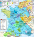 | 900 × 970 (1.22 MB) | Bibi Saint-Pol (talk | contribs) | {{Created with Inkscape}} == Description == {{Information |Description= {{en|Map of the France in 1477.}} {{fr|Carte de la France en 1477.}} |Source= {{fr| *France in the late 15th century, tirée du ''Muir's Historical A |
You cannot overwrite this file.
File usage on Commons
The following 16 pages use this file:
- Atlas of France
- Sancerre
- User:Chumwa/OgreBot/Charente-Maritime/2015 March 11-20
- File:Carte Lorraine 15eme.png
- File:Map France 1030-fr.svg
- File:Map France 1180-fr.svg
- File:Map France 1477-br.svg
- File:Map France 1477-de.svg
- File:Map France 1477-en.svg
- File:Map France 1477-es.svg
- File:Map France 1477-fr.svg
- File:Map France 1477-ru.svg
- File:Map France 1477-uk.svg
- File:Pays de Retz.jpg
- Template:Other versions/Map France 1477
- Category:Duchy of Bar
File usage on other wikis
The following other wikis use this file:
- Usage on af.wikipedia.org
- Usage on avk.wikipedia.org
- Usage on bg.wikipedia.org
- Usage on br.wikipedia.org
- Usage on cs.wikipedia.org
- Usage on da.wikipedia.org
- Usage on de.wikipedia.org
- Usage on el.wikipedia.org
- Usage on en.wikipedia.org
- Usage on eo.wikipedia.org
- Usage on es.wikipedia.org
- Usage on fa.wikipedia.org
- Usage on fr.wikipedia.org
- Domaine royal français
- Duché de Bourgogne
- Histoire de la Drôme
- Discussion:Cartographie/Archive01
- Fontenilles
- Bigorre (région naturelle)
- Liste des comtes et vicomtes de Châteaudun
- Utilisateur:Zigeuner~frwiki
- Histoire de l'Occitanie
- Utilisateur:Zigeuner/Contributions/Cartes
- Utilisateur:Zigeuner/Contributions
- Discussion:Bellet (AOC)
- Formation territoriale de la France
- Histoire de France
- Utilisateur:Mith/Cartes
- Discussion:Cartographie
- Wikipédia:Atelier graphique/Cartes/Archives/Demandes mises en sommeil/France
View more global usage of this file.
Metadata
This file contains additional information such as Exif metadata which may have been added by the digital camera, scanner, or software program used to create or digitize it. If the file has been modified from its original state, some details such as the timestamp may not fully reflect those of the original file. The timestamp is only as accurate as the clock in the camera, and it may be completely wrong.
| Width | 900 |
|---|---|
| Height | 970 |


